
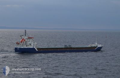
NIKLAS G.
General Cargo
Current Trip
| Time Travelled | 3 days |
|---|---|
| Remaining Time | --- |
| Distance Travelled | 466.93 nm |
| Remaining Distance | --- |
| AVG Speed | 10.1 Knots |
| MAX Speed | 11.3 Knots |
| AVG Wind | 9.3 knots |
| MAX Wind | 20.3 knots |
| MIN Temp | 12°C / 53.6°F |
| MAX Temp | 21.8°C / 71.24°F |
| Draught | 5.3 m |
| Position Received | 2 d ago |
Current Position
| Longitude | 16.88579° |
|---|---|
| Latitude | 56.09988° |
| Status | Under way using engine |
| Speed | 10.6 Knots |
| Course | 50.9° |
| Area | Baltic Sea |
| Station | T-AIS |
| Position Received | 2 d ago |
Info
Information
The current position of NIKLAS G. is in Baltic Sea with coordinates 56.09988° / 16.88579° as reported on 2024-05-27 16:49 by AIS to our vessel tracker app. The vessel's current speed is 10.6 Knots
The vessel NIKLAS G. (IMO: 9534303, MMSI: 305733000) is a General Cargo that was built in 2011 ( 13 years old ). It's sailing under the flag of [AG] Antigua Barbuda.
In this page you can find informations about the vessels current position, last detected port calls, and current voyage information. If the vessels is not in coverage by AIS you will find the latest position.
The current position of NIKLAS G. is detected by our AIS receivers and we are not responsible for the reliability of the data. The last position was recorded while the vessel was in Coverage by the Ais receivers of our vessel tracking app.
The current draught of NIKLAS G. as reported by AIS is 5.3 meters
Weather
| Temperature | 18.3°C / 64.94°F |
|---|---|
| Wind Speed | 6 knots |
| Direction | 354° N |
| Pressure | 1011 hPa |
| Humidity | 71.4 % |
| Cloud Coverage | 100 % |
Featured Company
Last Port Calls
| Port | Arrival | Departure | Time In Port |
|---|---|---|---|
| 2024-05-24 09:22 | 2024-05-26 23:00 | 2 d | |
| 2024-05-22 06:56 | 2024-05-23 17:35 | 1 d | |
| 2024-05-19 06:22 | 2024-05-20 13:06 | 1 d | |
| 2024-05-15 22:31 | 2024-05-17 14:30 | 1 d | |
| 2024-05-12 14:58 | 2024-05-14 17:21 | 2 d | |
| 2024-05-10 10:52 | 2024-05-11 15:41 | 1 d | |
| 2024-05-07 02:01 | 2024-05-07 16:07 | 14 h | |
| 2024-05-05 11:53 | 2024-05-06 04:31 | 16 h | |
| 2024-05-03 18:01 | 2024-05-04 16:11 | 22 h | |
| 2024-05-01 05:46 | 2024-05-02 01:07 | 19 h |
Most Visited Ports (Last year)
| Port | Arrivals | |
|---|---|---|
| 17 | ||
| 14 | ||
| 8 | ||
| 5 | ||
| 4 | ||
| 4 |
Last Trips
| Origin | Departure | Destination | Arrival | Distance | |
|---|---|---|---|---|---|
| 2024-05-23 19:35 | 2024-05-24 11:22 | 173.80 nm | |||
| 2024-05-20 16:06 | 2024-05-22 08:56 | 457.19 nm | |||
| 2024-05-17 16:30 | 2024-05-19 09:22 | 457.59 nm | |||
| 2024-05-14 19:21 | 2024-05-16 00:31 | 294.80 nm | |||
| 2024-05-11 17:41 | 2024-05-12 16:58 | 259.58 nm | |||
| 2024-05-07 18:07 | 2024-05-10 12:52 | 503.96 nm | |||
| 2024-05-06 06:31 | 2024-05-07 04:01 | 244.04 nm | |||
| 2024-05-04 18:11 | 2024-05-05 13:53 | 243.72 nm | |||
| 2024-05-02 04:07 | 2024-05-03 20:01 | 429.36 nm | |||
| 2024-04-29 14:53 | 2024-05-01 08:46 | 464.03 nm |
Events
| Time | Event | Details | Position / Dest | Info |
|---|---|---|---|---|
| 2024-05-29 17:58 | STOP Moving | 4.56 nm, North of RIGA |
57.02301 / 24.11969
LVRIX
|
Speed: 0.1 kn Course: 57° |
| 2024-05-29 17:42 | START Moving | 4.92 nm, North of RIGA |
57.03001 / 24.08871
LVRIX
|
Speed: 4.3 kn Course: 110° |
| 2024-05-28 19:25 | STOP Moving | 4.65 nm, North of RIGA |
57.02535 / 24.08548
LVRIX
|
Speed: 0.3 kn Course: 38° |
| 2024-05-27 16:53 | Status Changed | Default Under way using engine |
56.10735 / 16.90237
LVRIX
|
Speed: 10.6 kn Course: 50.9° |
| 2024-05-27 16:49 | OUT of Coverage |
56.09988 / 16.88579
Baltic Sea
LVRIX
|
Speed: 10.6 kn Course: 50.9° |
|
| 2024-05-27 11:16 | Change Sea Area | Swedish part of the Baltic Sea Danish part of the Kattegat |
55.61617 / 15.37178
Baltic Sea
LVRIX
|
Speed: 10.2 kn Course: 66.8° |
| 2024-05-27 06:52 | Detected in Sea | Danish part of the Kattegat |
55.18787 / 14.29576
Kattegat
LVRIX
|
Speed: 9.7 kn Course: 81.5° |
| 2024-05-27 00:55 | Change Sea Area | Swedish part of the Baltic Sea Danish part of the Baltic Sea |
55.29536 / 12.65186
Baltic Sea
LVRIX
|
Speed: 9.5 kn Course: 113.7° |
| 2024-05-27 00:41 | Change Sea Area | Danish part of the Baltic Sea Danish part of the Kattegat |
55.31509 / 12.59650
Baltic Sea
LVRIX
|
Speed: 9.6 kn Course: 132.1° |
| 2024-05-26 23:00 | PORT DEPARTURE |
|
55.45795 / 12.21311
LVRIX
|
Speed: 6.2 kn Course: 82° |