
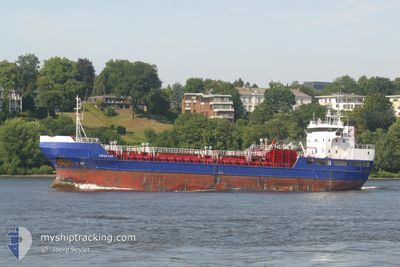
NOR STAR
Chemical Tanker
Current Trip
| Time Travelled | 6 days |
|---|---|
| Remaining Time | --- |
| Distance Travelled | 1190.33 nm |
| Remaining Distance | --- |
| AVG Speed | 9.7 Knots |
| MAX Speed | 11.9 Knots |
| AVG Wind | 16.4 knots |
| MAX Wind | 30.9 knots |
| MIN Temp | 6.1°C / 42.98°F |
| MAX Temp | 15.6°C / 60.08°F |
| Draught | 5.5 m |
| Position Received | 1 m ago |
Current Position
| Longitude | 5.34861° |
|---|---|
| Latitude | 63.04320° |
| Status | Under way using engine |
| Speed | 9.8 Knots |
| Course | 209.2° |
| Area | Norwegian Sea |
| Station | T-AIS |
| Position Received | 1 m ago |
Info
Information
The current position of NOR STAR is in Norwegian Sea with coordinates 63.04320° / 5.34861° as reported on 2024-06-10 05:16 by AIS to our vessel tracker app. The vessel's current speed is 9.8 Knots and is heading at the port of HVIDE SANDE. The estimated time of arrival as calculated by vessel tracking app is 2024-06-12 06:00 LT
The vessel NOR STAR (IMO: 8719102, MMSI: 630001042) is a Chemical Tanker that was built in 1992 ( 32 years old ). It's sailing under the flag of [GW] Guinea-Bissau.
In this page you can find informations about the vessels current position, last detected port calls, and current voyage information. If the vessels is not in coverage by AIS you will find the latest position.
The current position of NOR STAR is detected by our AIS receivers and we are not responsible for the reliability of the data. The last position was recorded while the vessel was in Coverage by the Ais receivers of our vessel tracking app.
The current draught of NOR STAR as reported by AIS is 5.5 meters
Weather
| Temperature | 10.6°C / 51.08°F |
|---|---|
| Wind Speed | 22 knots |
| Direction | 354° N |
| Pressure | 997.6 hPa |
| Humidity | 87.5 % |
| Cloud Coverage | 61 % |
Featured Company
Last Port Calls
| Port | Arrival | Departure | Time In Port |
|---|---|---|---|
| 2024-06-02 17:31 | 2024-06-03 14:49 | 21 h | |
| 2024-05-30 20:10 | 2024-05-31 06:03 | 9 h | |
| 2024-05-29 13:17 | 2024-05-29 22:22 | 9 h | |
| 2024-05-25 08:59 | 2024-05-25 14:29 | 5 h | |
| 2024-05-22 06:28 | 2024-05-22 16:26 | 9 h | |
| 2024-05-20 04:27 | 2024-05-21 00:16 | 19 h | |
| 2024-05-14 11:26 | 2024-05-15 21:37 | 1 d | |
| 2024-05-13 10:02 | 2024-05-13 21:07 | 11 h | |
| 2024-05-09 19:01 | 2024-05-10 18:46 | 23 h | |
| 2024-05-08 08:11 | 2024-05-09 05:27 | 21 h |
Last Trips
| Origin | Departure | Destination | Arrival | Distance | |
|---|---|---|---|---|---|
| 2024-05-31 08:03 | 2024-06-02 19:31 | 326.70 nm | |||
| 2024-05-30 00:22 | 2024-05-30 22:10 | 247.93 nm | |||
| 2024-05-25 16:29 | 2024-05-29 15:17 | 611.99 nm | |||
| 2024-05-22 18:26 | 2024-05-25 10:59 | 596.29 nm | |||
| 2024-05-21 02:16 | 2024-05-22 08:28 | 282.86 nm | |||
| 2024-05-15 23:37 | 2024-05-20 06:27 | 891.73 nm | |||
| 2024-05-13 23:07 | 2024-05-14 13:26 | 95.14 nm | |||
| 2024-05-10 20:46 | 2024-05-13 12:02 | 615.12 nm | |||
| 2024-05-09 07:27 | 2024-05-09 21:01 | 113.78 nm | |||
| 2024-04-29 11:38 | 2024-05-08 10:11 | 1714.61 nm |
Events
| Time | Event | Details | Position / Dest | Info |
|---|---|---|---|---|
| 2024-06-08 05:38 | ETA Changed | 2024/06/12 06:00 2024/06/12 10:00 |
69.66119 / 16.49739
DKHVS
|
Speed: 9.9 kn Course: 242.6° |
| 2024-06-07 20:08 | START Moving | 17.78 nm, East of TROMSO |
69.60953 / 19.80966
DKHVS
|
Speed: 7.1 kn Course: 340.5° |
| 2024-06-07 19:55 | Status Changed | Under way using engine Moored |
69.60504 / 19.81490
DKHVS
|
Speed: Course: 296° |
| 2024-06-07 17:26 | Draught Changed | 5.5 4.5 |
69.60504 / 19.81491
DKHVS
|
Speed: Course: 296° |
| 2024-06-07 17:26 | Destination Changed | DKHVS NOJOV |
69.60504 / 19.81491
DKHVS
|
Speed: Course: 296° |
| 2024-06-07 17:26 | ETA Changed | 2024/06/12 10:00 2024/06/07 06:00 |
69.60504 / 19.81491
DKHVS
|
Speed: Course: 296° |
| 2024-06-07 06:38 | Status Changed | Moored Under way using engine |
69.60504 / 19.81489
NOJOV
|
Speed: Course: 295° |
| 2024-06-07 06:28 | STOP Moving | 17.95 nm, East of TROMSO |
69.60510 / 19.81506
NOJOV
|
Speed: 0.2 kn Course: 292° |
| 2024-06-06 10:24 | START Moving | 0.99 nm, North East of STOKMARKNES |
68.57649 / 14.95336
NOJOV
|
Speed: 6.5 kn Course: 97° |
| 2024-06-06 10:16 | Status Changed | Under way using engine Moored |
68.57505 / 14.94810
NOJOV
|
Speed: Course: 287° |