
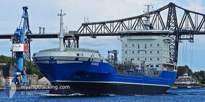
NORDIC
Oil/Chemical Tanker
Current Trip
| Time Travelled | 7 h, 5 mins |
|---|---|
| Remaining Time | 2 days |
| Distance Travelled | 79.57 nm |
| Remaining Distance | 646.48 nm |
| AVG Speed | 11.9 Knots |
| MAX Speed | 14.5 Knots |
| AVG Wind | 14.5 knots |
| MAX Wind | 18 knots |
| MIN Temp | 12.4°C / 54.32°F |
| MAX Temp | 14.5°C / 58.1°F |
| Draught | 6.2 m |
| Position Received | 7 m ago |
Current Position
| Longitude | -4.98743° |
|---|---|
| Latitude | 53.29797° |
| Status | Under way using engine |
| Speed | 9.9 Knots |
| Course | 203.8° |
| Area | Irish Sea and St. George's Channel |
| Station | T-AIS |
| Position Received | 7 m ago |
Info
Information
The current position of NORDIC is in Irish Sea and St. George's Channel with coordinates 53.29797° / -4.98743° as reported on 2024-05-29 00:37 by AIS to our vessel tracker app. The vessel's current speed is 9.9 Knots and is heading at the port of ROTTERDAM. The estimated time of arrival as calculated by vessel tracking app is 2024-05-31 17:29 LT
The vessel NORDIC (IMO: 9438444, MMSI: 219027463) is a Oil/Chemical Tanker that was built in 2008 ( 16 years old ). It's sailing under the flag of [DK] Denmark.
In this page you can find informations about the vessels current position, last detected port calls, and current voyage information. If the vessels is not in coverage by AIS you will find the latest position.
The current position of NORDIC is detected by our AIS receivers and we are not responsible for the reliability of the data. The last position was recorded while the vessel was in Coverage by the Ais receivers of our vessel tracking app.
The current draught of NORDIC as reported by AIS is 6.2 meters
Weather
| Temperature | 12.5°C / 54.5°F |
|---|---|
| Wind Speed | 15 knots |
| Direction | 266° W |
| Pressure | 1006.7 hPa |
| Humidity | 86.2 % |
| Cloud Coverage | 53 % |
Featured Company
Last Port Calls
| Port | Arrival | Departure | Time In Port |
|---|---|---|---|
| 2024-05-26 13:55 | 2024-05-28 17:39 | 2 d | |
| 2024-05-25 00:11 | 2024-05-26 12:57 | 1 d | |
| 2024-05-07 16:09 | 2024-05-09 07:55 | 1 d | |
| 2024-05-02 05:44 | 2024-05-03 18:06 | 1 d | |
| 2024-04-26 19:06 | 2024-04-27 20:46 | 1 d | |
| 2024-04-25 12:33 | 2024-04-26 18:33 | 1 d | |
| 2024-04-21 11:06 | 2024-04-22 16:29 | 1 d | |
| 2024-04-18 07:28 | 2024-04-19 11:48 | 1 d | |
| 2024-04-15 18:09 | 2024-04-17 02:18 | 1 d | |
| 2024-04-12 08:11 | 2024-04-13 08:45 | 1 d |
Last Trips
| Origin | Departure | Destination | Arrival | Distance | |
|---|---|---|---|---|---|
| 2024-05-26 13:57 | 2024-05-26 14:55 | 7.04 nm | |||
| 2024-05-09 09:55 | 2024-05-25 01:11 | 822.09 nm | |||
| 2024-05-03 19:06 | 2024-05-07 18:09 | 1031.74 nm | |||
| 2024-04-27 22:46 | 2024-05-02 06:44 | 1020.70 nm | |||
| 2024-04-26 20:33 | 2024-04-26 21:06 | 2.44 nm | |||
| 2024-04-22 18:29 | 2024-04-25 14:33 | 96.77 nm | |||
| 2024-04-19 13:48 | 2024-04-21 13:06 | 480.23 nm | |||
| 2024-04-17 04:18 | 2024-04-18 09:28 | 173.36 nm | |||
| 2024-04-13 10:45 | 2024-04-15 20:09 | 599.31 nm | |||
| 2024-04-10 14:02 | 2024-04-12 10:11 | 88.34 nm |
Events
| Time | Event | Details | Position / Dest | Info |
|---|---|---|---|---|
| 2024-05-29 00:35 | Status Changed | Under way using engine Default |
53.30137 / -4.98492
NL RTM
|
Speed: 9.8 kn Course: 204° |
| 2024-05-29 00:28 | Status Changed | Default Under way using engine |
53.32114 / -4.97025
NL RTM
|
Speed: 9.7 kn Course: 206.7° |
| 2024-05-29 00:14 | Status Changed | Under way using engine Default |
53.35557 / -4.94320
NL RTM
|
Speed: 9.7 kn Course: 205° |
| 2024-05-29 00:11 | Status Changed | Default Under way using engine |
53.36093 / -4.93908
NL RTM
|
Speed: 9.8 kn Course: 204.8° |
| 2024-05-28 23:47 | Status Changed | Under way using engine Default |
53.41868 / -4.88564
NL RTM
|
Speed: 9.6 kn Course: 214° |
| 2024-05-28 23:44 | Status Changed | Default Under way using engine |
53.42616 / -4.87704
NL RTM
|
Speed: 9.6 kn Course: 214.9° |
| 2024-05-28 23:21 | Status Changed | Under way using engine Default |
53.47516 / -4.81437
NL RTM
|
Speed: 9.4 kn Course: 220° |
| 2024-05-28 22:28 | Status Changed | Default Under way using engine |
53.55759 / -4.63057
NL RTM
|
Speed: 10.7 kn Course: 262.3° |
| 2024-05-28 22:17 | Status Changed | Under way using engine Default |
53.56173 / -4.57577
NL RTM
|
Speed: 11.1 kn Course: 264° |
| 2024-05-28 21:52 | Status Changed | Default Under way using engine |
53.56873 / -4.44589
NL RTM
|
Speed: 11.3 kn Course: 271.6° |