
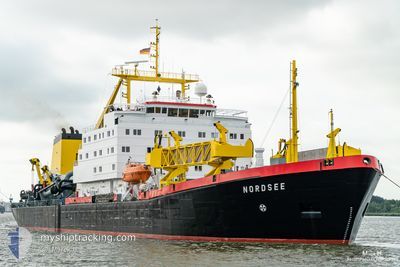
NORDSEE
Trailing Suction Hopper Dredger
Current Trip
DEWVN
| Time Travelled | 19 h, 45 mins |
|---|---|
| Remaining Time | --- |
| Distance Travelled | 48.66 nm |
| Remaining Distance | --- |
| AVG Speed | 10.1 Knots |
| MAX Speed | 13.5 Knots |
| AVG Wind | 8.8 knots |
| MAX Wind | 11 knots |
| MIN Temp | 12.6°C / 54.68°F |
| MAX Temp | 18.3°C / 64.94°F |
| Draught | 7.5 m |
| Position Received | 1 m ago |
Current Position
| Longitude | 8.16794° |
|---|---|
| Latitude | 53.60581° |
| Status | At anchor |
| Speed | 0.1 Knots |
| Course | 10° |
| Area | North Sea |
| Station | T-AIS |
| Position Received | 1 m ago |
Info
Information
The current position of NORDSEE is in North Sea with coordinates 53.60581° / 8.16794° as reported on 2024-05-19 03:38 by AIS to our vessel tracker app. The vessel's current speed is 0.1 Knots
The vessel NORDSEE (IMO: 7504108, MMSI: 211224140) is a Trailing Suction Hopper Dredger that was built in 1978 ( 46 years old ). It's sailing under the flag of [DE] Germany.
In this page you can find informations about the vessels current position, last detected port calls, and current voyage information. If the vessels is not in coverage by AIS you will find the latest position.
The current position of NORDSEE is detected by our AIS receivers and we are not responsible for the reliability of the data. The last position was recorded while the vessel was in Coverage by the Ais receivers of our vessel tracking app.
The current draught of NORDSEE as reported by AIS is 7.5 meters
Weather
| Temperature | 13.3°C / 55.94°F |
|---|---|
| Wind Speed | 7 knots |
| Direction | 52° NE |
| Pressure | 1009.7 hPa |
| Humidity | 88.3 % |
| Cloud Coverage | 51 % |
Featured Company
Last Port Calls
| Port | Arrival | Departure | Time In Port |
|---|---|---|---|
| 2024-05-18 07:20 | 2024-05-18 07:54 | 33 m | |
| 2024-05-17 11:49 | 2024-05-17 12:57 | 1 h | |
| 2024-05-17 05:17 | 2024-05-17 06:27 | 1 h | |
| 2024-05-16 10:19 | 2024-05-16 11:57 | 1 h | |
| 2024-05-16 04:42 | 2024-05-16 05:46 | 1 h | |
| 2024-05-15 15:07 | 2024-05-15 15:11 | 3 m | |
| 2024-05-15 08:50 | 2024-05-15 09:57 | 1 h | |
| 2024-05-14 05:18 | 2024-05-15 08:42 | 1 d | |
| 2024-05-13 21:29 | 2024-05-13 23:44 | 2 h | |
| 2024-05-13 15:43 | 2024-05-13 17:18 | 1 h |
Most Visited Ports (Last year)
| Port | Arrivals | |
|---|---|---|
| 449 | ||
| 2 |
Last Trips
| Origin | Departure | Destination | Arrival | Distance | |
|---|---|---|---|---|---|
| 2024-05-17 14:57 | 2024-05-18 09:20 | 29.69 nm | |||
| 2024-05-17 08:27 | 2024-05-17 13:49 | 48.00 nm | |||
| 2024-05-16 13:57 | 2024-05-17 07:17 | 50.03 nm | |||
| 2024-05-16 07:46 | 2024-05-16 12:19 | 48.42 nm | |||
| 2024-05-15 17:11 | 2024-05-16 06:42 | 3.40 nm | |||
| 2024-05-15 11:57 | 2024-05-15 17:07 | 48.95 nm | |||
| 2024-05-15 10:42 | 2024-05-15 10:50 | 1.56 nm | |||
| 2024-05-14 01:44 | 2024-05-14 07:18 | 44.12 nm | |||
| 2024-05-13 19:18 | 2024-05-13 23:29 | 47.16 nm | |||
| 2024-05-13 12:37 | 2024-05-13 17:43 | 46.38 nm |
Events
| Time | Event | Details | Position / Dest | Info |
|---|---|---|---|---|
| 2024-05-19 03:02 | Status Changed | At anchor Default |
53.60589 / 8.16771
DEWVN
|
Speed: 0.1 kn Course: 23° |
| 2024-05-19 02:59 | Status Changed | Default At anchor |
53.60590 / 8.16762
DEWVN
|
Speed: 0.1 kn Course: 25° |
| 2024-05-18 13:14 | ETA Changed | 2024/05/14 06:00 2024/05/21 07:00 |
53.60747 / 8.16841
DEWVN
|
Speed: 0.1 kn Course: 172° |
| 2024-05-18 13:14 | Status Changed | At anchor Under way using engine |
53.60743 / 8.16842
DEWVN
|
Speed: 0.3 kn Course: 177° |
| 2024-05-18 13:09 | STOP Moving | 4.09 nm, South East of HOOKSIEL |
53.60641 / 8.16822
DEWVN
|
Speed: 0.2 kn Course: 181° |
| 2024-05-18 10:51 | START Moving | 8.74 nm, North of WANGEROOGE |
53.91859 / 7.89022
DEWVN
|
Speed: 3.8 kn Course: 180° |
| 2024-05-18 10:42 | STOP Moving | 8.85 nm, North of WANGEROOGE |
53.92054 / 7.88975
DEWVN
|
Speed: 0.2 kn Course: 122° |
| 2024-05-18 10:26 | Status Changed | Under way using engine Default |
53.89941 / 7.88699
DEWVN
|
Speed: 10 kn Course: 5° |
| 2024-05-18 10:25 | Status Changed | Default Under way using engine |
53.89525 / 7.88640
DEWVN
|
Speed: 9.8 kn Course: 5.7° |
| 2024-05-18 07:54 | PORT DEPARTURE |
|
53.57870 / 8.16964
DEWVN
|
Speed: 1.5 kn Course: 353° |