
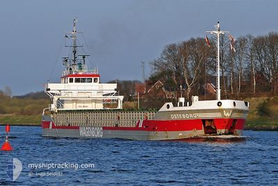
NS SPRINTER
General Cargo
Current Trip
| Trip Time | --- |
|---|---|
| Trip Distance | --- |
| AVG Speed | --- |
| MAX Speed | --- |
| Draught | --- |
| AVG Wind | --- |
| MAX Wind | --- |
| MIN Temp | --- |
| MAX Temp | --- |
| Position Received | 1 d ago |
Current Position
| Longitude | 19.39860° |
|---|---|
| Latitude | 41.36852° |
| Status | Under way using engine |
| Speed | 5.2 Knots |
| Course | 34.9° |
| Area | Adriatic Sea |
| Station | T-AIS |
| Position Received | 1 d ago |
Info
Information
The current position of NS SPRINTER is in Adriatic Sea with coordinates 41.36852° / 19.39860° as reported on 2024-06-27 05:15 by AIS to our vessel tracker app. The vessel's current speed is 5.2 Knots and is currently inside the port of RINIA.
The vessel NS SPRINTER (IMO: 9033866, MMSI: 312577000) is a General Cargo that was built in 1992 ( 32 years old ). It's sailing under the flag of [BZ] Belize.
In this page you can find informations about the vessels current position, last detected port calls, and current voyage information. If the vessels is not in coverage by AIS you will find the latest position.
The current position of NS SPRINTER is detected by our AIS receivers and we are not responsible for the reliability of the data. The last position was recorded while the vessel was in Coverage by the Ais receivers of our vessel tracking app.
The current draught of NS SPRINTER as reported by AIS is 3.2 meters
Weather
| Temperature | 25.1°C / 77.18°F |
|---|---|
| Wind Speed | 11 knots |
| Direction | 198° SSW |
| Pressure | 1010.2 hPa |
| Humidity | 74.6 % |
| Cloud Coverage | --- |
Featured Company
Last Port Calls
| Port | Arrival | Departure | Time In Port |
|---|---|---|---|
| 2024-06-14 08:56 | 2024-06-20 00:06 | 5 d | |
| 2024-06-12 10:05 | 2024-06-13 02:13 | 16 h | |
| 2024-05-24 08:17 | 2024-06-04 07:24 | 10 d | |
| 2024-05-17 08:56 | 2024-05-19 09:31 | 2 d | |
| 2024-05-02 10:42 | 2024-05-12 17:48 | 10 d | |
| 2024-04-30 05:16 | 2024-05-01 14:26 | 1 d | |
| 2024-04-20 14:04 | |||
| 2024-04-09 08:39 |
Most Visited Ports (Last year)
| Port | Arrivals | |
|---|---|---|
| 3 | ||
| 2 | ||
| 2 | ||
| 2 | ||
| 2 | ||
| 2 |
Last Trips
| Origin | Departure | Destination | Arrival | Distance | |
|---|---|---|---|---|---|
| 2024-06-13 05:13 | 2024-06-14 11:56 | 7.24 nm | |||
| 2024-06-04 09:24 | 2024-06-12 13:05 | 1035.26 nm | |||
| 2024-05-19 12:31 | 2024-05-24 10:17 | 731.02 nm | |||
| 2024-05-12 19:48 | 2024-05-17 11:56 | 729.89 nm | |||
| 2024-05-01 16:26 | 2024-05-02 12:42 | 11.57 nm | |||
| 2024-04-20 17:04 | 2024-04-30 07:16 | 1276.92 nm |
Events
| Time | Event | Details | Position / Dest | Info |
|---|---|---|---|---|
| 2024-06-27 05:15 | OUT of Coverage |
41.36852 / 19.39860
Adriatic Sea
|
Speed: 5.2 kn Course: 34.9° |
|
| 2024-06-27 05:15 | START Moving | 0.83 nm, South of RINIA |
41.36852 / 19.39860
DURRES ALB
|
Speed: 5.2 kn Course: 34.9° |
| 2024-06-27 04:42 | Status Changed | Under way using engine Constrained by her draught |
41.35603 / 19.38528
DURRES ALB
|
Speed: 0.1 kn Course: 178° |
| 2024-06-27 04:34 | IN Coverage |
41.35610 / 19.38527
Adriatic Sea
|
Speed: 0.1 kn Course: 185.8° |
|
| 2024-06-27 03:21 | OUT of Coverage |
41.35615 / 19.38580
Adriatic Sea
|
Speed: 0.1 kn Course: 207.1° |
|
| 2024-06-27 03:17 | IN Coverage |
41.35615 / 19.38583
Adriatic Sea
|
Speed: 0.1 kn Course: 168.8° |
|
| 2024-06-26 20:49 | OUT of Coverage |
41.33382 / 19.38312
Adriatic Sea
|
Speed: 6.9 kn Course: 3.1° |
|
| 2024-06-26 19:37 | IN Coverage |
41.20658 / 19.37957
Adriatic Sea
|
Speed: 6.4 kn Course: 4.1° |
|
| 2024-06-26 17:35 | OUT of Coverage |
40.98528 / 19.33028
Adriatic Sea
|
Speed: 6.3 kn Course: 12.5° |
|
| 2024-06-26 17:35 | IN Coverage |
40.98528 / 19.33028
Adriatic Sea
|
Speed: 6.3 kn Course: 12.5° |