
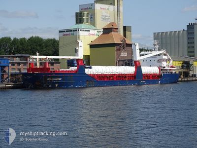
OCEAN CARRIER
General Cargo
Current Trip
| Time Travelled | 10 days |
|---|---|
| Remaining Time | 47 mins |
| Distance Travelled | 2695.46 nm |
| Remaining Distance | 66.44 nm |
| AVG Speed | 10.5 Knots |
| MAX Speed | 14.4 Knots |
| AVG Wind | 12.1 knots |
| MAX Wind | 23 knots |
| MIN Temp | 10.5°C / 50.9°F |
| MAX Temp | 22.6°C / 72.68°F |
| Draught | 8 m |
| Position Received | 5 h, 20 m ago |
Current Position
| Longitude | 11.91268° |
|---|---|
| Latitude | 34.67224° |
| Status | Under way using engine |
| Speed | 10.8 Knots |
| Course | 253.2° |
| Area | Mediterranean Sea - Eastern Basin |
| Station | T-AIS |
| Position Received | 5 h, 20 m ago |
Info
Information
The current position of OCEAN CARRIER is in Mediterranean Sea - Eastern Basin with coordinates 34.67224° / 11.91268° as reported on 2024-05-29 00:21 by AIS to our vessel tracker app. The vessel's current speed is 10.8 Knots and is heading at the port of SFAX. The estimated time of arrival as calculated by vessel tracking app is 2024-05-29 06:28 LT
The vessel OCEAN CARRIER (IMO: 9349435, MMSI: 255805917) is a General Cargo that was built in 2010 ( 14 years old ). It's sailing under the flag of [PT] Portugal.
In this page you can find informations about the vessels current position, last detected port calls, and current voyage information. If the vessels is not in coverage by AIS you will find the latest position.
The current position of OCEAN CARRIER is detected by our AIS receivers and we are not responsible for the reliability of the data. The last position was recorded while the vessel was in Coverage by the Ais receivers of our vessel tracking app.
The current draught of OCEAN CARRIER as reported by AIS is 8 meters
Weather
| Temperature | 22°C / 71.6°F |
|---|---|
| Wind Speed | 19 knots |
| Direction | 20° NNE |
| Pressure | 1014.1 hPa |
| Humidity | 73.5 % |
| Cloud Coverage | 45 % |
Featured Company
Last Port Calls
| Port | Arrival | Departure | Time In Port |
|---|---|---|---|
| 2024-05-18 18:13 | 2024-05-18 19:31 | 1 h | |
| 2024-05-18 06:48 | 2024-05-18 07:55 | 1 h | |
| 2024-05-12 08:40 | 2024-05-15 08:36 | 2 d | |
| 2024-05-09 18:11 | 2024-05-10 21:08 | 1 d | |
| 2024-04-30 14:48 | 2024-05-01 12:18 | 21 h | |
| 2024-04-28 05:00 | 2024-04-30 01:09 | 1 d | |
| 2024-04-11 15:11 | 2024-04-15 11:03 | 3 d | |
| 2024-04-05 07:14 | 2024-04-09 11:59 | 4 d | |
| 2024-03-25 11:26 | 2024-03-25 15:23 | 3 h | |
| 2024-03-19 01:00 | 2024-03-19 02:51 | 1 h |
Most Visited Ports (Last year)
| Port | Arrivals | |
|---|---|---|
| 4 | ||
| 4 | ||
| 4 | ||
| 3 | ||
| 3 | ||
| 3 |
Last Trips
| Origin | Departure | Destination | Arrival | Distance | |
|---|---|---|---|---|---|
| 2024-05-18 09:55 | 2024-05-18 20:13 | 50.88 nm | |||
| 2024-05-15 11:36 | 2024-05-18 08:48 | 713.44 nm | |||
| 2024-05-11 00:08 | 2024-05-12 11:40 | 391.63 nm | |||
| 2024-05-01 14:18 | 2024-05-09 21:11 | 1495.17 nm | |||
| 2024-04-30 03:09 | 2024-04-30 16:48 | 143.36 nm | |||
| 2024-04-15 12:03 | 2024-04-28 07:00 | 3097.62 nm | |||
| 2024-04-09 12:59 | 2024-04-11 16:11 | 103.92 nm | |||
| 2024-03-25 16:23 | 2024-04-05 08:14 | 1121.81 nm | |||
| 2024-03-19 03:51 | 2024-03-25 12:26 | 1664.77 nm | |||
| 2024-03-16 07:11 | 2024-03-19 02:00 | 674.85 nm |
Events
| Time | Event | Details | Position / Dest | Info |
|---|---|---|---|---|
| 2024-05-29 00:26 | Status Changed | Default Under way using engine |
34.66806 / 11.89584
TNSFA
|
Speed: 10.8 kn Course: 253.2° |
| 2024-05-29 00:21 | OUT of Coverage |
34.67224 / 11.91268
Mediterranean Sea - Eastern Basin
TNSFA
|
Speed: 10.8 kn Course: 253.2° |
|
| 2024-05-28 23:42 | Status Changed | Under way using engine Default |
34.70700 / 12.05226
TNSFA
|
Speed: 11 kn Course: 248° |
| 2024-05-28 23:33 | IN Coverage |
34.70495 / 12.04526
Mediterranean Sea - Eastern Basin
TNSFA
|
Speed: 11 kn Course: 250.3° |
|
| 2024-05-28 22:22 | Status Changed | Default Under way using engine |
34.90104 / 12.09434
TNSFA
|
Speed: 10.9 kn Course: 168.7° |
| 2024-05-28 22:18 | OUT of Coverage |
34.91106 / 12.09189
Mediterranean Sea - Eastern Basin
TNSFA
|
Speed: 10.9 kn Course: 168.7° |
|
| 2024-05-28 21:59 | Status Changed | Under way using engine Default |
34.96820 / 12.07787
TNSFA
|
Speed: 10.9 kn Course: 169° |
| 2024-05-28 21:42 | IN Coverage |
34.96820 / 12.07787
Mediterranean Sea - Eastern Basin
TNSFA
|
Speed: 10.9 kn Course: 168.8° |
|
| 2024-05-28 11:19 | Status Changed | Default Under way using engine |
36.81167 / 11.51500
TNSFA
|
Speed: 10.4 kn Course: 161.9° |
| 2024-05-28 11:13 | OUT of Coverage |
36.83073 / 11.50731
Mediterranean Sea - Eastern Basin
TNSFA
|
Speed: 10.4 kn Course: 161.9° |