
OCEAN SURVEYOR
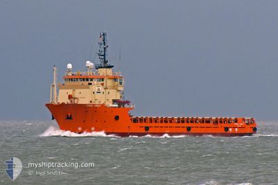
Offshore Supply Ship
Current Trip
SURVEY AREA
| Time Travelled | 3 days |
|---|---|
| Remaining Time | --- |
| Distance Travelled | 100.09 nm |
| Remaining Distance | --- |
| AVG Speed | 7.1 Knots |
| MAX Speed | 11.1 Knots |
| AVG Wind | 12 knots |
| MAX Wind | 16.9 knots |
| MIN Temp | 18.1°C / 64.58°F |
| MAX Temp | 21.8°C / 71.24°F |
| Draught | 6.5 m |
| Position Received | 2 d ago |
Current Position
| Longitude | 153.76158° |
|---|---|
| Latitude | -26.94840° |
| Status | Restricted manoeuverability |
| Speed | 0.3 Knots |
| Course | 185° |
| Area | Coral Sea |
| Station | T-AIS |
| Position Received | 2 d ago |
Info
Information
The current position of OCEAN SURVEYOR is in Coral Sea with coordinates -26.94840° / 153.76158° as reported on 2024-06-22 03:50 by AIS to our vessel tracker app. The vessel's current speed is 0.3 Knots
The vessel OCEAN SURVEYOR (IMO: 9182215, MMSI: 538010817) is a Offshore Supply Ship that was built in 1999 ( 25 years old ). It's sailing under the flag of [MH] Marshall Is.
In this page you can find informations about the vessels current position, last detected port calls, and current voyage information. If the vessels is not in coverage by AIS you will find the latest position.
The current position of OCEAN SURVEYOR is detected by our AIS receivers and we are not responsible for the reliability of the data. The last position was recorded while the vessel was in Coverage by the Ais receivers of our vessel tracking app.
The current draught of OCEAN SURVEYOR as reported by AIS is 6.5 meters
Weather
| Temperature | 18.5°C / 65.3°F |
|---|---|
| Wind Speed | 10 knots |
| Direction | 190° S |
| Pressure | 1019.8 hPa |
| Humidity | 60.4 % |
| Cloud Coverage | 100 % |
Featured Company
Last Trips
| Origin | Departure | Destination | Arrival | Distance | |
|---|---|---|---|---|---|
| 2024-06-01 09:16 | 2024-06-18 12:33 | 763.61 nm | |||
| 2024-05-11 08:57 | 2024-05-25 12:30 | 1054.72 nm | |||
| 2024-04-14 16:13 | 2024-05-09 14:37 | 2370.96 nm | |||
| 2024-03-08 09:33 | 2024-04-13 07:33 | 2267.75 nm |
Events
| Time | Event | Details | Position / Dest | Info |
|---|---|---|---|---|
| 2024-06-22 03:50 | OUT of Coverage |
-26.94840 / 153.76158
Coral Sea
|
Speed: 0.3 kn Course: 222° |
|
| 2024-06-22 01:14 | STOP Moving | 20.68 nm, North East of BULWER |
-26.92906 / 153.71611
SURVEY AREA
|
Speed: 0.2 kn Course: 204° |
| 2024-06-22 00:31 | START Moving | 18.87 nm, North East of BULWER |
-26.91692 / 153.67110
SURVEY AREA
|
Speed: 4.1 kn Course: 107° |
| 2024-06-21 23:53 | STOP Moving | 18.8 nm, North East of BULWER |
-26.91503 / 153.66824
SURVEY AREA
|
Speed: 0.3 kn Course: 204° |
| 2024-06-21 23:12 | START Moving | 17.19 nm, North East of BULWER |
-26.90269 / 153.62299
SURVEY AREA
|
Speed: 4.3 kn Course: 123° |
| 2024-06-21 22:21 | STOP Moving | 17.14 nm, North East of BULWER |
-26.90105 / 153.62042
SURVEY AREA
|
Speed: 0.2 kn Course: 202° |
| 2024-06-21 21:44 | START Moving | 15.75 nm, North East of BULWER |
-26.88824 / 153.57358
SURVEY AREA
|
Speed: 4.3 kn Course: 101° |
| 2024-06-21 20:58 | STOP Moving | 15.76 nm, North East of BULWER |
-26.88671 / 153.57230
SURVEY AREA
|
Speed: 0.3 kn Course: 230° |
| 2024-06-21 20:11 | START Moving | 15.22 nm, North East of BULWER |
-26.86616 / 153.52882
SURVEY AREA
|
Speed: 3.2 kn Course: 137° |
| 2024-06-21 19:12 | STOP Moving | 15.33 nm, North East of BULWER |
-26.86398 / 153.52899
SURVEY AREA
|
Speed: 0.3 kn Course: 196° |