
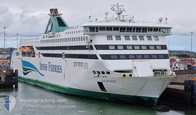
OSCAR WILDE
Ro-Ro/Passenger Ship
Current Trip
| Trip Time | 3 h, 39 mins |
|---|---|
| Trip Distance | 58.52 nm |
| AVG Speed | 16.5 Knots |
| MAX Speed | 20.4 Knots |
| Draught | 6.6 m |
| AVG Wind | 7.7 knots |
| MAX Wind | 10.1 knots |
| MIN Temp | 11°C / 51.8°F |
| MAX Temp | 12.6°C / 54.68°F |
| Position Received | 1 m ago |
Current Position
| Longitude | -6.19800° |
|---|---|
| Latitude | 53.34533° |
| Status | Under way using engine |
| Speed | 0.1 Knots |
| Course | 180° |
| Area | Irish Sea and St. George's Channel |
| Station | T-AIS |
| Position Received | 1 m ago |
Info
Information
The current position of OSCAR WILDE is in Irish Sea and St. George's Channel with coordinates 53.34533° / -6.19800° as reported on 2024-05-17 17:57 by AIS to our vessel tracker app. The vessel's current speed is 0.1 Knots and is currently inside the port of DUBLIN.
The vessel OSCAR WILDE (IMO: 9364722, MMSI: 209170000) is a Ro-Ro/Passenger Ship that was built in 2007 ( 17 years old ). It's sailing under the flag of [CY] Cyprus.
In this page you can find informations about the vessels current position, last detected port calls, and current voyage information. If the vessels is not in coverage by AIS you will find the latest position.
The current position of OSCAR WILDE is detected by our AIS receivers and we are not responsible for the reliability of the data. The last position was recorded while the vessel was in Coverage by the Ais receivers of our vessel tracking app.
The current draught of OSCAR WILDE as reported by AIS is 6.6 meters
Weather
| Temperature | 15.1°C / 59.18°F |
|---|---|
| Wind Speed | 4 knots |
| Direction | 32° NNE |
| Pressure | 1012.4 hPa |
| Humidity | 77.7 % |
| Cloud Coverage | 89 % |
Featured Company
Last Port Calls
| Port | Arrival | Departure | Time In Port |
|---|---|---|---|
| 2024-05-17 10:38 | |||
| 2024-05-17 04:12 | 2024-05-17 06:59 | 2 h | |
| 2024-05-16 22:45 | 2024-05-17 01:15 | 2 h | |
| 2024-05-16 16:49 | 2024-05-16 19:21 | 2 h | |
| 2024-05-16 10:36 | 2024-05-16 14:14 | 3 h | |
| 2024-05-16 04:16 | 2024-05-16 07:07 | 2 h | |
| 2024-05-15 22:33 | 2024-05-16 00:59 | 2 h | |
| 2024-05-15 16:46 | 2024-05-15 19:11 | 2 h | |
| 2024-05-15 10:36 | 2024-05-15 13:27 | 2 h | |
| 2024-05-15 04:10 | 2024-05-15 07:21 | 3 h |
Last Trips
| Origin | Departure | Destination | Arrival | Distance | |
|---|---|---|---|---|---|
| 2024-05-17 07:59 | 2024-05-17 11:38 | 58.52 nm | |||
| 2024-05-17 02:15 | 2024-05-17 05:12 | 57.50 nm | |||
| 2024-05-16 20:21 | 2024-05-16 23:45 | 58.59 nm | |||
| 2024-05-16 15:14 | 2024-05-16 17:49 | 56.64 nm | |||
| 2024-05-16 08:07 | 2024-05-16 11:36 | 58.10 nm | |||
| 2024-05-16 01:59 | 2024-05-16 05:16 | 56.15 nm | |||
| 2024-05-15 20:11 | 2024-05-15 23:33 | 58.73 nm | |||
| 2024-05-15 14:27 | 2024-05-15 17:46 | 56.27 nm | |||
| 2024-05-15 08:21 | 2024-05-15 11:36 | 58.07 nm | |||
| 2024-05-15 02:11 | 2024-05-15 05:10 | 56.22 nm |
Events
| Time | Event | Details | Position / Dest | Info |
|---|---|---|---|---|
| 2024-05-17 17:55 | Status Changed | Under way using engine Moored |
53.34533 / -6.19800
[IE] DUBLIN
|
Speed: 0.1 kn Course: 181° |
| 2024-05-17 10:50 | ETA Changed | 2024/05/18 14:30 2024/05/17 11:45 |
53.34533 / -6.19800
[IE] DUBLIN
|
Speed: 0.1 kn Course: 182° |
| 2024-05-17 10:50 | Status Changed | Moored Under way using engine |
53.34533 / -6.19800
[IE] DUBLIN
|
Speed: 0.1 kn Course: 182° |
| 2024-05-17 10:38 | STOP Moving |
53.34333 / -6.19817
[IE] DUBLIN
|
Speed: 0.2 kn Course: 174° |
|
| 2024-05-17 10:38 | PORT ARRIVAL |
|
53.34333 / -6.19817
[IE] DUBLIN
|
Speed: 0.7 kn Course: 177° |
| 2024-05-17 08:29 | Change Sea Area | Irish part of the Irish Sea and St. George's Channel United Kingdom part of the Irish Sea and St. George's Channel |
53.33733 / -5.32517
Irish Sea and St. George's Channel
IEDUBGBHLY
|
Speed: 17.5 kn Course: 267° |
| 2024-05-17 08:03 | Status Changed | Under way using engine Default |
53.34067 / -5.11517
IEDUBGBHLY
|
Speed: 17.3 kn Course: 274° |
| 2024-05-17 07:46 | Status Changed | Default Under way using engine |
53.33917 / -4.97966
IEDUBGBHLY
|
Speed: 18.2 kn Course: 268° |
| 2024-05-17 06:59 | PORT DEPARTURE |
|
53.32500 / -4.61350
IEDUBGBHLY
|
Speed: 14.2 kn Course: 35° |
| 2024-05-17 06:58 | START Moving |
53.32150 / -4.61783
[GB] HOLYHEAD
|
Speed: 10.7 kn Course: 36° |