
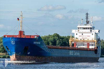
OSTBENSE
General Cargo
Current Trip
| Time Travelled | 15 h, 56 mins |
|---|---|
| Remaining Time | 1 day |
| Distance Travelled | 171.08 nm |
| Remaining Distance | 334.93 nm |
| AVG Speed | 11.2 Knots |
| MAX Speed | 11.8 Knots |
| AVG Wind | 15.2 knots |
| MAX Wind | 22 knots |
| MIN Temp | 9.4°C / 48.92°F |
| MAX Temp | 11.1°C / 51.98°F |
| Draught | 4.8 m |
| Position Received | 1 m ago |
Current Position
| Longitude | 19.58969° |
|---|---|
| Latitude | 59.82214° |
| Status | Under way using engine |
| Speed | 11.4 Knots |
| Course | 141.6° |
| Area | Gulf of Bothnia |
| Station | T-AIS |
| Position Received | 1 m ago |
Info
Information
The current position of OSTBENSE is in Gulf of Bothnia with coordinates 59.82214° / 19.58969° as reported on 2024-06-11 03:45 by AIS to our vessel tracker app. The vessel's current speed is 11.4 Knots and is heading at the port of GDANSK. The estimated time of arrival as calculated by vessel tracking app is 2024-06-12 08:34 LT
The vessel OSTBENSE (IMO: 9566784, MMSI: 305631000) is a General Cargo that was built in 2011 ( 13 years old ). It's sailing under the flag of [AG] Antigua Barbuda.
In this page you can find informations about the vessels current position, last detected port calls, and current voyage information. If the vessels is not in coverage by AIS you will find the latest position.
The current position of OSTBENSE is detected by our AIS receivers and we are not responsible for the reliability of the data. The last position was recorded while the vessel was in Coverage by the Ais receivers of our vessel tracking app.
The current draught of OSTBENSE as reported by AIS is 4.8 meters
Weather
| Temperature | 10°C / 50°F |
|---|---|
| Wind Speed | 11 knots |
| Direction | 261° W |
| Pressure | 999 hPa |
| Humidity | 84.9 % |
| Cloud Coverage | --- |
Featured Company
Last Port Calls
| Port | Arrival | Departure | Time In Port |
|---|---|---|---|
| 2024-06-09 09:20 | 2024-06-10 11:51 | 1 d | |
| 2024-06-05 09:11 | 2024-06-07 13:19 | 2 d | |
| 2024-05-31 10:17 | 2024-06-03 12:07 | 3 d | |
| 2024-05-27 04:34 | 2024-05-29 13:43 | 2 d | |
| 2024-05-23 20:50 | 2024-05-24 14:22 | 17 h | |
| 2024-05-20 03:58 | 2024-05-21 23:03 | 1 d | |
| 2024-05-16 21:23 | 2024-05-17 14:16 | 16 h | |
| 2024-05-13 10:37 | 2024-05-14 23:44 | 1 d | |
| 2024-05-10 12:29 | 2024-05-11 14:29 | 1 d | |
| 2024-05-05 21:20 | 2024-05-08 13:42 | 2 d |
Last Trips
| Origin | Departure | Destination | Arrival | Distance | |
|---|---|---|---|---|---|
| 2024-06-07 15:19 | 2024-06-09 12:20 | 512.25 nm | |||
| 2024-06-03 15:07 | 2024-06-05 11:11 | 510.75 nm | |||
| 2024-05-29 15:43 | 2024-05-31 13:17 | 512.12 nm | |||
| 2024-05-24 17:22 | 2024-05-27 06:34 | 510.10 nm | |||
| 2024-05-22 01:03 | 2024-05-23 23:50 | 512.03 nm | |||
| 2024-05-17 17:16 | 2024-05-20 05:58 | 511.17 nm | |||
| 2024-05-15 01:44 | 2024-05-17 00:23 | 517.42 nm | |||
| 2024-05-11 17:29 | 2024-05-13 12:37 | 510.12 nm | |||
| 2024-05-08 15:42 | 2024-05-10 15:29 | 513.00 nm | |||
| 2024-05-01 01:03 | 2024-05-05 23:20 | 917.44 nm |
Events
| Time | Event | Details | Position / Dest | Info |
|---|---|---|---|---|
| 2024-06-10 23:50 | Draught Changed | 4.8 5.4 |
60.48113 / 18.98652
PL GDN
|
Speed: 11.8 kn Course: 180.4° |
| 2024-06-10 23:50 | Destination Changed | PL GDN FI KAS |
60.48113 / 18.98652
PL GDN
|
Speed: 11.8 kn Course: 180.4° |
| 2024-06-10 23:50 | ETA Changed | 2024/06/12 10:00 2024/06/09 10:00 |
60.48113 / 18.98652
PL GDN
|
Speed: 11.8 kn Course: 180.4° |
| 2024-06-10 23:48 | Status Changed | Under way using engine Default |
60.48542 / 18.98715
FI KAS
|
Speed: 11.7 kn Course: 196° |
| 2024-06-10 23:33 | Status Changed | Default Under way using engine |
60.52896 / 19.02760
FI KAS
|
Speed: 11.5 kn Course: 210.1° |
| 2024-06-10 23:22 | Status Changed | Under way using engine Default |
60.56024 / 19.06489
FI KAS
|
Speed: 11.5 kn Course: 210° |
| 2024-06-10 23:17 | IN Coverage |
60.55750 / 19.06161
Gulf of Bothnia
|
Speed: 11.5 kn Course: 210.4° |
|
| 2024-06-10 11:51 | PORT DEPARTURE |
|
62.28638 / 21.16914
FI KAS
|
Speed: Course: 12° |
| 2024-06-09 09:34 | STOP Moving |
62.35169 / 21.21433
[FI] KASKINEN
|
Speed: Course: 11° |
|
| 2024-06-09 09:20 | PORT ARRIVAL |
|
62.35146 / 21.21408
[FI] KASKINEN
|
Speed: 7.6 kn Course: 16° |