
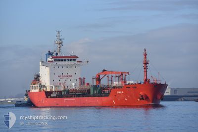
OWL 6
Oil/Chemical Tanker
Current Trip
| Time Travelled | 27 days |
|---|---|
| Remaining Time | --- |
| Distance Travelled | 1999.11 nm |
| Remaining Distance | --- |
| AVG Speed | 9.4 Knots |
| MAX Speed | 12.5 Knots |
| AVG Wind | 9.7 knots |
| MAX Wind | 20 knots |
| MIN Temp | 21.2°C / 70.16°F |
| MAX Temp | 32.9°C / 91.22°F |
| Draught | 6 m |
| Position Received | 8 d ago |
Current Position
| Longitude | -81.27448° |
|---|---|
| Latitude | 18.88013° |
| Status | Under way using engine |
| Speed | 11.2 Knots |
| Course | 111.7° |
| Area | Caribbean Sea |
| Station | T-AIS |
| Position Received | 8 d ago |
Info
Information
The current position of OWL 6 is in Caribbean Sea with coordinates 18.88013° / -81.27448° as reported on 2024-05-26 01:52 by AIS to our vessel tracker app. The vessel's current speed is 11.2 Knots
The vessel OWL 6 (IMO: 9340350, MMSI: 538007359) is a Oil/Chemical Tanker that was built in 2007 ( 17 years old ). It's sailing under the flag of [MH] Marshall Is.
In this page you can find informations about the vessels current position, last detected port calls, and current voyage information. If the vessels is not in coverage by AIS you will find the latest position.
The current position of OWL 6 is detected by our AIS receivers and we are not responsible for the reliability of the data. The last position was recorded while the vessel was in Coverage by the Ais receivers of our vessel tracking app.
The current draught of OWL 6 as reported by AIS is 6 meters
Weather
| Temperature | 22.3°C / 72.14°F |
|---|---|
| Wind Speed | 3 knots |
| Direction | 26° NNE |
| Pressure | 1011.9 hPa |
| Humidity | 81.8 % |
| Cloud Coverage | 42 % |
Featured Company
Last Port Calls
| Port | Arrival | Departure | Time In Port |
|---|---|---|---|
| 2024-05-05 06:57 | 2024-05-07 08:09 | 2 d | |
| 2024-04-28 16:41 | 2024-04-30 19:14 | 2 d | |
| 2024-04-20 03:22 | 2024-04-20 21:36 | 18 h | |
| 2024-04-18 17:51 | 2024-04-20 02:02 | 1 d | |
| 2024-04-17 10:31 | 2024-04-18 16:22 | 1 d |
Last Trips
| Origin | Departure | Destination | Arrival | Distance | |
|---|---|---|---|---|---|
| 2024-04-30 14:14 | 2024-05-05 01:57 | 696.06 nm | |||
| 2024-04-20 17:36 | 2024-04-28 11:41 | 2020.66 nm | |||
| 2024-04-19 22:02 | 2024-04-19 23:22 | 8.13 nm | |||
| 2024-04-18 12:22 | 2024-04-18 13:51 | 8.50 nm | |||
| 2024-03-30 19:45 | 2024-04-17 06:31 | 3788.22 nm |
Events
| Time | Event | Details | Position / Dest | Info |
|---|---|---|---|---|
| 2024-05-27 02:35 | STOP Moving | 4.74 nm, South East of KINGSTON (JM) |
17.89168 / -76.77451
JMKIN
|
Speed: 0.1 kn Course: 132° |
| 2024-05-26 01:59 | Status Changed | Default Under way using engine |
18.87259 / -81.25446
JMKIN
|
Speed: 11.2 kn Course: 111.7° |
| 2024-05-26 01:52 | Status Changed | Under way using engine Default |
18.88013 / -81.27448
JMKIN
|
Speed: 11.2 kn Course: 113° |
| 2024-05-26 01:52 | OUT of Coverage |
18.88013 / -81.27448
Caribbean Sea
JMKIN
|
Speed: 11.2 kn Course: 111.7° |
|
| 2024-05-26 01:51 | Status Changed | Default Under way using engine |
18.88173 / -81.27862
JMKIN
|
Speed: 11.2 kn Course: 112.8° |
| 2024-05-26 01:44 | Status Changed | Under way using engine Default |
18.88956 / -81.29841
JMKIN
|
Speed: 11.3 kn Course: 113° |
| 2024-05-26 01:42 | IN Coverage |
18.88812 / -81.29485
Caribbean Sea
JMKIN
|
Speed: 11.2 kn Course: 112.8° |
|
| 2024-05-26 00:50 | Status Changed | Default Under way using engine |
18.96460 / -81.46320
JMKIN
|
Speed: 11.7 kn Course: 105.5° |
| 2024-05-26 00:44 | Status Changed | Under way using engine Default |
18.97046 / -81.48288
JMKIN
|
Speed: 11.8 kn Course: 105° |
| 2024-05-26 00:44 | OUT of Coverage |
18.97046 / -81.48288
Caribbean Sea
JMKIN
|
Speed: 11.7 kn Course: 105.5° |