
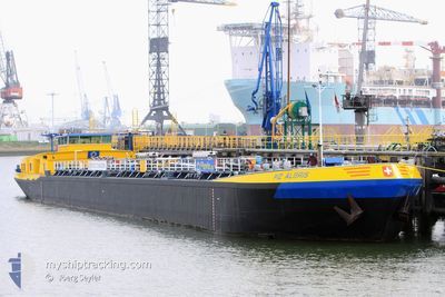
PIZ ALBRIS
Tanker
Current Trip
| Trip Time | 14 mins |
|---|---|
| Trip Distance | 1.06 nm |
| AVG Speed | 3.5 Knots |
| MAX Speed | 3.8 Knots |
| Draught | 1.6 m |
| AVG Wind | 2 knots |
| MAX Wind | 2 knots |
| MIN Temp | 13.2°C / 55.76°F |
| MAX Temp | 13.2°C / 55.76°F |
| Position Received | 3 h, 9 m ago |
Current Position
| Longitude | 6.66343° |
|---|---|
| Latitude | 51.36791° |
| Status | Under way using engine |
| Speed | 0.2 Knots |
| Course | --- |
| Area | North Sea |
| Station | T-AIS |
| Position Received | 3 h, 9 m ago |
Info
Information
The current position of PIZ ALBRIS is in North Sea with coordinates 51.36791° / 6.66343° as reported on 2024-05-18 04:23 by AIS to our vessel tracker app. The vessel's current speed is 0.2 Knots and is currently inside the port of KREFELD.
The vessel PIZ ALBRIS (MMSI: 269057206) is a Tanker It's sailing under the flag of [CH] Switzerland.
In this page you can find informations about the vessels current position, last detected port calls, and current voyage information. If the vessels is not in coverage by AIS you will find the latest position.
The current position of PIZ ALBRIS is detected by our AIS receivers and we are not responsible for the reliability of the data. The last position was recorded while the vessel was in Coverage by the Ais receivers of our vessel tracking app.
The current draught of PIZ ALBRIS as reported by AIS is 1.6 meters
Weather
| Temperature | 13.2°C / 55.76°F |
|---|---|
| Wind Speed | 2 knots |
| Direction | 223° SW |
| Pressure | 1008.8 hPa |
| Humidity | 95.7 % |
| Cloud Coverage | 75 % |
Featured Company
Last Port Calls
| Port | Arrival | Departure | Time In Port |
|---|---|---|---|
| 2024-05-18 04:15 | |||
| 2024-05-18 03:55 | 2024-05-18 04:01 | 6 m | |
| 2024-05-14 13:53 | 2024-05-14 14:31 | 37 m | |
| 2024-05-14 06:32 | 2024-05-14 12:49 | 6 h | |
| 2024-05-13 09:41 | 2024-05-13 10:42 | 1 h | |
| 2024-05-10 18:56 | 2024-05-12 18:55 | 1 d | |
| 2024-05-09 14:21 | 2024-05-10 11:06 | 20 h | |
| 2024-05-04 04:52 | 2024-05-04 05:45 | 53 m | |
| 2024-05-03 22:51 | 2024-05-03 23:02 | 10 m | |
| 2024-05-03 03:12 | 2024-05-03 18:38 | 15 h |
Most Visited Ports (Last year)
| Port | Arrivals | |
|---|---|---|
| 25 | ||
| 22 | ||
| 20 | ||
| 17 | ||
| 16 | ||
| 16 |
Last Trips
| Origin | Departure | Destination | Arrival | Distance | |
|---|---|---|---|---|---|
| 2024-05-18 06:01 | 2024-05-18 06:15 | 1.06 nm | |||
| 2024-05-14 16:31 | 2024-05-18 05:55 | 292.89 nm | |||
| 2024-05-14 14:49 | 2024-05-14 15:53 | 4.19 nm | |||
| 2024-05-13 12:42 | 2024-05-14 08:32 | 84.75 nm | |||
| 2024-05-12 20:55 | 2024-05-13 11:41 | 94.30 nm | |||
| 2024-05-10 13:06 | 2024-05-10 20:56 | 50.28 nm | |||
| 2024-05-04 07:45 | 2024-05-09 16:21 | 510.63 nm | |||
| 2024-05-04 01:02 | 2024-05-04 06:52 | 29.55 nm | |||
| 2024-05-03 20:38 | 2024-05-04 00:51 | 31.19 nm | |||
| 2024-05-03 00:51 | 2024-05-03 05:12 | 26.65 nm |
Events
| Time | Event | Details | Position / Dest | Info |
|---|---|---|---|---|
| 2024-05-18 04:23 | OUT of Coverage |
51.36791 / 6.66343
North Sea
[DE] KREFELD
|
Speed: 0.2 kn Course: 24.5° |
|
| 2024-05-18 04:21 | STOP Moving |
51.36789 / 6.66345
[DE] KREFELD
|
Speed: 0.2 kn Course: 511° |
|
| 2024-05-18 04:15 | PORT ARRIVAL |
|
51.36854 / 6.66620
[DE] KREFELD
|
Speed: 3 kn Course: 251.3° |
| 2024-05-18 04:01 | PORT DEPARTURE |
|
51.36964 / 6.67175
UERDINGEN
|
Speed: 8.5 kn Course: 66.1° |
| 2024-05-18 03:55 | PORT ARRIVAL |
|
51.36067 / 6.65441
[DE] KREFELD
|
Speed: 8.1 kn Course: 14.9° |
| 2024-05-17 20:05 | IN Coverage |
50.46576 / 7.35423
North Sea
UERDINGEN
|
Speed: 11.9 kn Course: 317.5° |
|
| 2024-05-17 15:41 | OUT of Coverage |
49.97269 / 7.91659
North Sea
UERDINGEN
|
Speed: 10.2 kn Course: 268.9° |
|
| 2024-05-17 11:45 | IN Coverage |
49.71411 / 8.41310
North Sea
UERDINGEN
|
Speed: 9.8 kn Course: 78.5° |
|
| 2024-05-17 10:32 | OUT of Coverage |
49.54831 / 8.41936
North Sea
UERDINGEN
|
Speed: 9.3 kn Course: 332.7° |
|
| 2024-05-17 10:23 | START Moving | 2.37 nm, North of MANNHEIM |
49.52754 / 8.42877
UERDINGEN
|
Speed: 3.2 kn Course: 9.9° |