
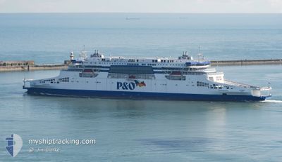
P&O PIONEER
Passenger
Current Trip
| Trip Time | 3 h, 26 mins |
|---|---|
| Trip Distance | 46.36 nm |
| AVG Speed | 16 Knots |
| MAX Speed | 20.9 Knots |
| Draught | 6.6 m |
| AVG Wind | 5 knots |
| MAX Wind | 6 knots |
| MIN Temp | 12.6°C / 54.68°F |
| MAX Temp | 13.3°C / 55.94°F |
| Position Received | 1 m ago |
Current Position
| Longitude | 1.34437° |
|---|---|
| Latitude | 51.12065° |
| Status | Under way using engine |
| Speed | 12 Knots |
| Course | 106° |
| Area | English Channel |
| Station | T-AIS |
| Position Received | 1 m ago |
Info
Information
The current position of P&O PIONEER is in English Channel with coordinates 51.12065° / 1.34437° as reported on 2024-05-18 10:21 by AIS to our vessel tracker app. The vessel's current speed is 12 Knots and is currently inside the port of DOVER.
The vessel P&O PIONEER (IMO: 9895161, MMSI: 210385000) is a Passenger It's sailing under the flag of [CY] Cyprus.
In this page you can find informations about the vessels current position, last detected port calls, and current voyage information. If the vessels is not in coverage by AIS you will find the latest position.
The current position of P&O PIONEER is detected by our AIS receivers and we are not responsible for the reliability of the data. The last position was recorded while the vessel was in Coverage by the Ais receivers of our vessel tracking app.
The current draught of P&O PIONEER as reported by AIS is 6.6 meters
Weather
| Temperature | 13.6°C / 56.48°F |
|---|---|
| Wind Speed | 4 knots |
| Direction | 248° WSW |
| Pressure | 1013.4 hPa |
| Humidity | 90.9 % |
| Cloud Coverage | 91 % |
Featured Company
Last Port Calls
| Port | Arrival | Departure | Time In Port |
|---|---|---|---|
| 2024-05-18 09:12 | |||
| 2024-05-18 04:26 | 2024-05-18 05:46 | 1 h | |
| 2024-05-17 18:54 | 2024-05-17 19:56 | 1 h | |
| 2024-05-17 13:57 | 2024-05-17 15:01 | 1 h | |
| 2024-05-17 09:14 | 2024-05-17 10:26 | 1 h | |
| 2024-05-17 04:25 | 2024-05-17 05:42 | 1 h | |
| 2024-05-16 20:58 | 2024-05-17 03:09 | 6 h | |
| 2024-05-16 18:24 | 2024-05-16 19:40 | 1 h | |
| 2024-05-16 12:58 | 2024-05-16 14:20 | 1 h | |
| 2024-05-16 07:41 | 2024-05-16 09:08 | 1 h |
Last Trips
| Origin | Departure | Destination | Arrival | Distance | |
|---|---|---|---|---|---|
| 2024-05-18 06:46 | 2024-05-18 10:12 | 46.36 nm | |||
| 2024-05-17 20:56 | 2024-05-18 05:26 | 46.64 nm | |||
| 2024-05-17 16:01 | 2024-05-17 19:54 | 46.39 nm | |||
| 2024-05-17 11:26 | 2024-05-17 14:57 | 46.35 nm | |||
| 2024-05-17 06:42 | 2024-05-17 10:14 | 46.01 nm | |||
| 2024-05-17 05:09 | 2024-05-17 05:25 | 21.57 nm | |||
| 2024-05-16 20:40 | 2024-05-16 22:58 | 21.91 nm | |||
| 2024-05-16 15:20 | 2024-05-16 19:24 | 45.97 nm | |||
| 2024-05-16 10:08 | 2024-05-16 13:58 | 45.99 nm | |||
| 2024-05-16 03:16 | 2024-05-16 08:41 | 45.95 nm |
Events
| Time | Event | Details | Position / Dest | Info |
|---|---|---|---|---|
| 2024-05-18 10:20 | Status Changed | Under way using engine Default |
51.12121 / 1.33774
[GB] DOVER
|
Speed: 0.1 kn Course: 138° |
| 2024-05-18 10:20 | START Moving |
51.12121 / 1.33774
[GB] DOVER
|
Speed: 8.1 kn Course: 92° |
|
| 2024-05-18 09:20 | STOP Moving |
51.12254 / 1.33403
[GB] DOVER
|
Speed: Course: 319° |
|
| 2024-05-18 09:13 | Status Changed | Default Under way using engine |
51.12135 / 1.33713
[GB] DOVER
|
Speed: 15.6 kn Course: 277.6° |
| 2024-05-18 09:12 | PORT ARRIVAL |
|
51.12135 / 1.33713
[GB] DOVER
|
Speed: 15.6 kn Course: 277.6° |
| 2024-05-18 09:08 | OUT of Coverage |
51.11970 / 1.36292
English Channel
[GB] DOVER
|
Speed: 15.6 kn Course: 277.6° |
|
| 2024-05-18 09:01 | Change Sea Area | United Kingdom part of the English Channel United Kingdom part of the North Sea |
51.11017 / 1.41255
English Channel
|
Speed: 18.6 kn Course: 287.5° |
| 2024-05-18 08:40 | Change Sea Area | United Kingdom part of the North Sea French part of the North Sea |
51.05448 / 1.56209
North Sea
|
Speed: 19.2 kn Course: 298.9° |
| 2024-05-18 07:54 | START Moving | 0.92 nm, North East of CALAIS |
50.97913 / 1.86841
DOV-CAL-DOV
|
Speed: 8.8 kn Course: 283.3° |
| 2024-05-18 07:03 | STOP Moving | 0.98 nm, North East of CALAIS |
50.97846 / 1.87130
DOV-CAL-DOV
|
Speed: 0.3 kn Course: 101° |