
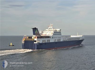
POL MARIS
Ro-Ro Cargo
Current Trip
| Time Travelled | 1 day |
|---|---|
| Remaining Time | --- |
| Distance Travelled | 537.37 nm |
| Remaining Distance | --- |
| AVG Speed | 17.9 Knots |
| MAX Speed | 18.9 Knots |
| AVG Wind | 5.3 knots |
| MAX Wind | 8 knots |
| MIN Temp | 17.5°C / 63.5°F |
| MAX Temp | 21.5°C / 70.7°F |
| Draught | 6.8 m |
| Position Received | Now |
Current Position
| Longitude | 20.00082° |
|---|---|
| Latitude | 38.82828° |
| Status | Under way using engine |
| Speed | 18.3 Knots |
| Course | 160° |
| Area | Ionian Sea |
| Station | T-AIS |
| Position Received | Now |
Info
Information
The current position of POL MARIS is in Ionian Sea with coordinates 38.82828° / 20.00082° as reported on 2024-05-29 00:45 by AIS to our vessel tracker app. The vessel's current speed is 18.3 Knots and is heading at the port of PENDIK. The estimated time of arrival as calculated by vessel tracking app is 2024-05-30 17:00 LT
The vessel POL MARIS (IMO: 9457189, MMSI: 215830000) is a Ro-Ro Cargo that was built in 2010 ( 14 years old ). It's sailing under the flag of [MT] Malta.
In this page you can find informations about the vessels current position, last detected port calls, and current voyage information. If the vessels is not in coverage by AIS you will find the latest position.
The current position of POL MARIS is detected by our AIS receivers and we are not responsible for the reliability of the data. The last position was recorded while the vessel was in Coverage by the Ais receivers of our vessel tracking app.
The current draught of POL MARIS as reported by AIS is 6.8 meters
Weather
| Temperature | 20.2°C / 68.36°F |
|---|---|
| Wind Speed | 3 knots |
| Direction | 230° SW |
| Pressure | 1014.2 hPa |
| Humidity | 72.1 % |
| Cloud Coverage | 11 % |
Featured Company
Last Port Calls
| Port | Arrival | Departure | Time In Port |
|---|---|---|---|
| 2024-05-27 07:17 | 2024-05-27 18:41 | 11 h | |
| 2024-05-20 15:09 | 2024-05-23 19:52 | 3 d | |
| 2024-05-18 06:52 | 2024-05-18 10:37 | 3 h | |
| 2024-05-16 17:14 | 2024-05-17 12:45 | 19 h | |
| 2024-05-14 10:04 | 2024-05-14 12:03 | 1 h | |
| 2024-05-12 01:35 | 2024-05-12 21:36 | 20 h | |
| 2024-05-10 04:12 | 2024-05-10 07:26 | 3 h | |
| 2024-05-08 07:18 | 2024-05-08 18:20 | 11 h | |
| 2024-05-07 05:15 | 2024-05-07 12:47 | 7 h | |
| 2024-05-02 18:23 | 2024-05-05 01:47 | 2 d |
Last Trips
| Origin | Departure | Destination | Arrival | Distance | |
|---|---|---|---|---|---|
| 2024-05-23 22:52 | 2024-05-27 09:17 | 1182.20 nm | |||
| 2024-05-18 12:37 | 2024-05-20 18:09 | 862.09 nm | |||
| 2024-05-17 14:45 | 2024-05-18 08:52 | 342.22 nm | |||
| 2024-05-14 15:03 | 2024-05-16 19:14 | 617.27 nm | |||
| 2024-05-13 00:36 | 2024-05-14 13:04 | 633.10 nm | |||
| 2024-05-10 10:26 | 2024-05-12 04:35 | 621.51 nm | |||
| 2024-05-08 20:20 | 2024-05-10 07:12 | 630.51 nm | |||
| 2024-05-07 14:47 | 2024-05-08 09:18 | 334.70 nm | |||
| 2024-05-05 04:47 | 2024-05-07 07:15 | 875.32 nm | |||
| 2024-04-29 20:14 | 2024-05-02 21:23 | 1197.54 nm |
Events
| Time | Event | Details | Position / Dest | Info |
|---|---|---|---|---|
| 2024-05-28 23:54 | Status Changed | Under way using engine Default |
39.03889 / 19.84568
TRPEN
|
Speed: 16.9 kn Course: 145° |
| 2024-05-28 23:45 | IN Coverage |
39.03889 / 19.84568
Ionian Sea
TRPEN
|
Speed: 17 kn Course: 145.5° |
|
| 2024-05-28 21:24 | Status Changed | Default Under way using engine |
39.61610 / 19.33084
TRPEN
|
Speed: 17 kn Course: 143.9° |
| 2024-05-28 21:00 | OUT of Coverage |
39.71097 / 19.24380
Ionian Sea
TRPEN
|
Speed: 17 kn Course: 143.9° |
|
| 2024-05-28 20:48 | Change Sea Area | Greek part of the Ionian Sea Greek part of the Adriatic Sea |
39.75854 / 19.19916
Ionian Sea
TRPEN
|
Speed: 17 kn Course: 144.2° |
| 2024-05-28 20:37 | Change Sea Area | Greek part of the Adriatic Sea Italian part of the Adriatic Sea |
39.79798 / 19.16235
Adriatic Sea
TRPEN
|
Speed: 17 kn Course: 144.2° |
| 2024-05-28 20:37 | Status Changed | Under way using engine Default |
39.79919 / 19.16121
TRPEN
|
Speed: 17.1 kn Course: 144° |
| 2024-05-28 20:29 | IN Coverage |
39.79798 / 19.16235
Adriatic Sea
TRPEN
|
Speed: 17 kn Course: 144.2° |
|
| 2024-05-28 19:29 | Status Changed | Default Under way using engine |
40.04640 / 18.86606
TRPEN
|
Speed: 18.3 kn Course: 136.5° |
| 2024-05-28 19:25 | OUT of Coverage |
40.06152 / 18.84733
Adriatic Sea
TRPEN
|
Speed: 18.3 kn Course: 136.5° |