
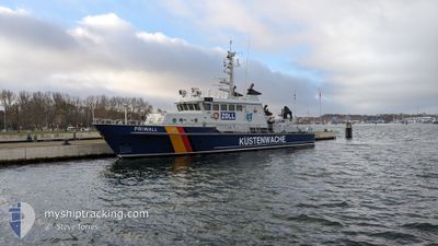
PRIWALL
Patrol Vessel
Current Trip
TRAVEMUENDE
| Time Travelled | 7 days |
|---|---|
| Remaining Time | --- |
| Distance Travelled | 72.59 nm |
| Remaining Distance | --- |
| AVG Speed | 9.4 Knots |
| MAX Speed | 12.6 Knots |
| AVG Wind | 9.3 knots |
| MAX Wind | 13 knots |
| MIN Temp | 14°C / 57.2°F |
| MAX Temp | 17.6°C / 63.68°F |
| Draught | 2.2 m |
| Position Received | 3 d ago |
Current Position
| Longitude | 11.03861° |
|---|---|
| Latitude | 54.15161° |
| Status | Under way using engine |
| Speed | 11.1 Knots |
| Course | 50.9° |
| Area | Baltic Sea |
| Station | T-AIS |
| Position Received | 3 d ago |
Info
Information
The current position of PRIWALL is in Baltic Sea with coordinates 54.15161° / 11.03861° as reported on 2024-06-03 07:48 by AIS to our vessel tracker app. The vessel's current speed is 11.1 Knots
The vessel PRIWALL (IMO: 9015943, MMSI: 211255310) is a Patrol Vessel that was built in 1991 ( 33 years old ). It's sailing under the flag of [DE] Germany.
In this page you can find informations about the vessels current position, last detected port calls, and current voyage information. If the vessels is not in coverage by AIS you will find the latest position.
The current position of PRIWALL is detected by our AIS receivers and we are not responsible for the reliability of the data. The last position was recorded while the vessel was in Coverage by the Ais receivers of our vessel tracking app.
The current draught of PRIWALL as reported by AIS is 2.2 meters
Weather
| Temperature | 13.8°C / 56.84°F |
|---|---|
| Wind Speed | 13 knots |
| Direction | 294° WNW |
| Pressure | 1015.7 hPa |
| Humidity | 80.8 % |
| Cloud Coverage | 77 % |
Featured Company
Last Port Calls
| Port | Arrival | Departure | Time In Port |
|---|---|---|---|
| 2024-05-27 15:56 | 2024-05-29 10:37 | 1 d | |
| 2024-05-27 07:01 | 2024-05-27 12:33 | 5 h | |
| 2024-05-27 06:04 | 2024-05-27 06:12 | 7 m | |
| 2024-05-23 10:30 | 2024-05-27 04:35 | 3 d | |
| 2024-05-17 03:13 | 2024-05-23 06:09 | 6 d | |
| 2024-05-16 20:23 | 2024-05-17 02:46 | 6 h | |
| 2024-05-16 18:54 | |||
| 2024-04-24 16:02 | 2024-04-25 07:37 | 15 h | |
| 2024-04-20 14:21 | 2024-04-24 13:06 | 3 d | |
| 2024-04-20 09:49 | 2024-04-20 13:51 | 4 h |
Most Visited Ports (Last year)
| Port | Arrivals | |
|---|---|---|
| 51 | ||
| 15 | ||
| 12 | ||
| 1 | ||
| 1 |
Last Trips
| Origin | Departure | Destination | Arrival | Distance | |
|---|---|---|---|---|---|
| 2024-05-27 14:33 | 2024-05-27 17:56 | 21.75 nm | |||
| 2024-05-27 08:12 | 2024-05-27 09:01 | 9.71 nm | |||
| 2024-05-27 06:35 | 2024-05-27 08:04 | 0.37 nm | |||
| 2024-05-23 08:09 | 2024-05-23 12:30 | 13.15 nm | |||
| 2024-05-17 04:46 | 2024-05-17 05:13 | 3.44 nm | |||
| 2024-05-16 20:54 | 2024-05-16 22:23 | 8.41 nm | |||
| 2024-04-24 15:06 | 2024-04-24 18:02 | 10.29 nm | |||
| 2024-04-20 15:51 | 2024-04-20 16:21 | 3.75 nm | |||
| 2024-04-20 08:49 | 2024-04-20 11:49 | 17.94 nm | |||
| 2024-04-15 20:16 | 2024-04-15 22:55 | 17.74 nm |
Events
| Time | Event | Details | Position / Dest | Info |
|---|---|---|---|---|
| 2024-06-03 07:48 | OUT of Coverage |
54.15161 / 11.03861
Baltic Sea
|
Speed: 11.1 kn Course: 50.9° |
|
| 2024-06-03 07:48 | IN Coverage |
54.15161 / 11.03861
Baltic Sea
|
Speed: 11.1 kn Course: 50.9° |
|
| 2024-05-31 09:33 | OUT of Coverage |
54.03624 / 11.48718
Baltic Sea
TRAVEMUENDE
|
Speed: 1.6 kn Course: 319.6° |
|
| 2024-05-31 08:53 | START Moving | 4.32 nm, North West of HAFFANLEGER RERIK |
54.14026 / 11.50542
TRAVEMUENDE
|
Speed: 10.9 kn Course: 184.7° |
| 2024-05-31 08:51 | ETA Changed | 2024/05/31 16:00 2024/05/27 16:00 |
54.14197 / 11.50572
TRAVEMUENDE
|
Speed: 0.4 kn Course: 167° |
| 2024-05-31 08:50 | STOP Moving | 4.39 nm, North West of HAFFANLEGER RERIK |
54.14253 / 11.50554
TRAVEMUENDE
|
Speed: 0.3 kn Course: 195° |
| 2024-05-31 08:16 | Status Changed | Under way using engine Default |
54.21893 / 11.49956
TRAVEMUENDE
|
Speed: 11.6 kn Course: 58° |
| 2024-05-31 08:09 | Status Changed | Default Under way using engine |
54.20650 / 11.46561
TRAVEMUENDE
|
Speed: 11.5 kn Course: 57.9° |
| 2024-05-31 08:03 | Status Changed | Under way using engine Default |
54.19683 / 11.43919
TRAVEMUENDE
|
Speed: 12 kn Course: 56° |
| 2024-05-31 07:49 | IN Coverage |
54.19740 / 11.44073
Baltic Sea
|
Speed: 11.5 kn Course: 57.9° |