
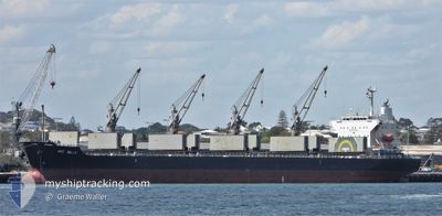
PRT BELLE
Bulk Carrier
Current Trip
KARIMUN INDONESIA
| Time Travelled | 10 days |
|---|---|
| Remaining Time | --- |
| Distance Travelled | 2661.05 nm |
| Remaining Distance | --- |
| AVG Speed | 11.8 Knots |
| MAX Speed | 15.5 Knots |
| AVG Wind | 9.7 knots |
| MAX Wind | 16 knots |
| MIN Temp | 13.5°C / 56.3°F |
| MAX Temp | 30.5°C / 86.9°F |
| Draught | 8.3 m |
| Position Received | 6 h, 11 m ago |
Current Position
| Longitude | 103.24726° |
|---|---|
| Latitude | 1.08219° |
| Status | Under way using engine |
| Speed | 10.9 Knots |
| Course | 2.5° |
| Area | Malacca Strait |
| Station | T-AIS |
| Position Received | 6 h, 11 m ago |
Info
Information
The current position of PRT BELLE is in Malacca Strait with coordinates 1.08219° / 103.24726° as reported on 2024-05-12 06:50 by AIS to our vessel tracker app. The vessel's current speed is 10.9 Knots
The vessel PRT BELLE (IMO: 9615119, MMSI: 373393000) is a Bulk Carrier that was built in 2012 ( 12 years old ). It's sailing under the flag of [PA] Panama.
In this page you can find informations about the vessels current position, last detected port calls, and current voyage information. If the vessels is not in coverage by AIS you will find the latest position.
The current position of PRT BELLE is detected by our AIS receivers and we are not responsible for the reliability of the data. The last position was recorded while the vessel was in Coverage by the Ais receivers of our vessel tracking app.
The current draught of PRT BELLE as reported by AIS is 8.3 meters
Weather
| Temperature | 30.4°C / 86.72°F |
|---|---|
| Wind Speed | 12 knots |
| Direction | 118° ESE |
| Pressure | 1008.1 hPa |
| Humidity | 73.4 % |
| Cloud Coverage | 92 % |
Featured Company
Last Port Calls
| Port | Arrival | Departure | Time In Port |
|---|---|---|---|
| 2024-05-01 22:00 | 2024-05-02 09:20 | 11 h | |
| 2024-04-27 04:44 | 2024-04-30 20:23 | 3 d | |
| 2024-04-21 23:20 | 2024-04-24 23:36 | 3 d | |
| 2024-04-06 19:52 | 2024-04-08 14:18 | 1 d | |
| 2024-03-28 02:41 | 2024-03-30 02:41 | 2 d | |
| 2024-03-13 21:39 | 2024-03-17 22:40 | 4 d | |
| 2024-03-12 02:31 | 2024-03-13 20:28 | 1 d |
Most Visited Ports (Last year)
| Port | Arrivals | |
|---|---|---|
| 3 | ||
| 2 | ||
| 1 | ||
| 1 | ||
| 1 | ||
| 1 |
Last Trips
| Origin | Departure | Destination | Arrival | Distance | |
|---|---|---|---|---|---|
| 2024-05-01 05:23 | 2024-05-02 07:00 | 232.97 nm | |||
| 2024-04-25 08:36 | 2024-04-27 13:44 | 225.38 nm | |||
| 2024-04-08 22:18 | 2024-04-22 08:20 | 3469.18 nm | |||
| 2024-03-30 09:41 | 2024-04-07 03:52 | 2343.31 nm | |||
| 2024-03-18 07:40 | 2024-03-28 09:41 | 2577.50 nm | |||
| 2024-03-14 05:28 | 2024-03-14 06:39 | 4.41 nm | |||
| 2023-12-19 13:01 | 2024-03-12 11:31 | 2083.18 nm |
Events
| Time | Event | Details | Position / Dest | Info |
|---|---|---|---|---|
| 2024-05-12 06:57 | Status Changed | Default Under way using engine |
1.10197 / 103.24733
KARIMUN INDONESIA
|
Speed: 10.9 kn Course: 2.5° |
| 2024-05-12 06:50 | OUT of Coverage |
1.08219 / 103.24726
Malacca Strait
|
Speed: 10.9 kn Course: 2.5° |
|
| 2024-05-12 06:50 | Status Changed | Under way using engine Default |
1.08066 / 103.24719
KARIMUN INDONESIA
|
Speed: 10.1 kn Course: 350° |
| 2024-05-12 06:49 | Status Changed | Default Under way using engine |
1.07672 / 103.24725
KARIMUN INDONESIA
|
Speed: 10.8 kn Course: 298.4° |
| 2024-05-12 06:40 | Status Changed | Under way using engine Default |
1.06295 / 103.26780
KARIMUN INDONESIA
|
Speed: 9.9 kn Course: 307° |
| 2024-05-12 06:25 | IN Coverage |
1.06295 / 103.26780
Malacca Strait
|
Speed: 10.5 kn Course: 298.2° |
|
| 2024-05-12 06:13 | START Moving |
1.03704 / 103.31213
KARIMUN INDONESIA
|
Speed: 4.6 kn Course: 252° |
|
| 2024-05-11 04:28 | STOP Moving |
1.04169 / 103.31738
KARIMUN INDONESIA
|
Speed: Course: 270° |
|
| 2024-05-11 02:53 | Status Changed | Default Under way using engine |
1.04551 / 103.28241
KARIMUN INDONESIA
|
Speed: 3.9 kn Course: 88° |
| 2024-05-11 02:46 | OUT of Coverage |
1.04720 / 103.27545
Malacca Strait
KARIMUN INDONESIA
|
Speed: 3.9 kn Course: 102.9° |