
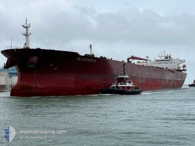
PS GENOVA
Oil Products Tanker
Current Trip
LYRLA > CAPTU
| Time Travelled | 37 days |
|---|---|
| Remaining Time | --- |
| Distance Travelled | 8557.51 nm |
| Remaining Distance | --- |
| AVG Speed | 12.7 Knots |
| MAX Speed | 12.7 Knots |
| AVG Wind | 12.3 knots |
| MAX Wind | 26 knots |
| MIN Temp | 16.5°C / 61.7°F |
| MAX Temp | 34.2°C / 93.56°F |
| Draught | 12.4 m |
| Position Received | 16 m ago |
Current Position
| Longitude | 7.07291° |
|---|---|
| Latitude | 37.50266° |
| Status | Under way using engine |
| Speed | 12.9 Knots |
| Course | 260.1° |
| Area | Mediterranean Sea - Western Basin |
| Station | T-AIS |
| Position Received | 16 m ago |
Info
Information
The current position of PS GENOVA is in Mediterranean Sea - Western Basin with coordinates 37.50266° / 7.07291° as reported on 2024-06-27 09:32 by AIS to our vessel tracker app. The vessel's current speed is 12.9 Knots
The vessel PS GENOVA (IMO: 9439383, MMSI: 229903000) is a Oil Products Tanker that was built in 2010 ( 14 years old ). It's sailing under the flag of [MT] Malta.
In this page you can find informations about the vessels current position, last detected port calls, and current voyage information. If the vessels is not in coverage by AIS you will find the latest position.
The current position of PS GENOVA is detected by our AIS receivers and we are not responsible for the reliability of the data. The last position was recorded while the vessel was in Coverage by the Ais receivers of our vessel tracking app.
The current draught of PS GENOVA as reported by AIS is 12.4 meters
Weather
| Temperature | 23.6°C / 74.48°F |
|---|---|
| Wind Speed | 18 knots |
| Direction | 89° E |
| Pressure | 1009.6 hPa |
| Humidity | 83.4 % |
| Cloud Coverage | 1 % |
Featured Company
Last Port Calls
| Port | Arrival | Departure | Time In Port |
|---|---|---|---|
| 2024-05-17 06:14 | 2024-05-20 14:54 | 3 d | |
| 2024-05-13 18:10 | 2024-05-13 21:35 | 3 h | |
| 2024-05-11 15:15 | 2024-05-13 17:58 | 2 d | |
| 2024-05-11 10:03 | 2024-05-11 14:58 | 4 h | |
| 2024-05-08 13:13 | 2024-05-09 15:10 | 1 d | |
| 2024-04-28 07:37 | 2024-04-30 09:18 | 2 d | |
| 2024-04-15 19:21 | 2024-04-15 20:01 | 40 m | |
| 2024-04-01 13:10 |
Most Visited Ports (Last year)
| Port | Arrivals | |
|---|---|---|
| 4 | ||
| 3 | ||
| 2 | ||
| 2 | ||
| 2 | ||
| 2 |
Last Trips
| Origin | Departure | Destination | Arrival | Distance | |
|---|---|---|---|---|---|
| 2024-05-13 16:35 | 2024-05-17 01:14 | 804.48 nm | |||
| 2024-05-13 12:58 | 2024-05-13 13:10 | 2.12 nm | |||
| 2024-05-11 09:58 | 2024-05-11 10:15 | 2.00 nm | |||
| 2024-05-09 10:10 | 2024-05-11 05:03 | 538.95 nm | |||
| 2024-04-30 04:18 | 2024-05-08 08:13 | 657.03 nm | |||
| 2024-04-15 15:01 | 2024-04-28 02:37 | 895.06 nm | |||
| 2024-04-01 08:10 | 2024-04-15 14:21 | 321.06 nm |
Events
| Time | Event | Details | Position / Dest | Info |
|---|---|---|---|---|
| 2024-06-27 09:38 | Status Changed | Default Under way using engine |
37.49993 / 7.04896
LYRLA > CAPTU
|
Speed: 12.9 kn Course: 260.1° |
| 2024-06-27 09:23 | Status Changed | Under way using engine Default |
37.50566 / 7.11442
LYRLA > CAPTU
|
Speed: 12.9 kn Course: 267° |
| 2024-06-27 09:06 | Status Changed | Default Under way using engine |
37.50917 / 7.19287
LYRLA > CAPTU
|
Speed: 12.8 kn Course: 266.4° |
| 2024-06-27 09:00 | Status Changed | Under way using engine Default |
37.51050 / 7.21988
LYRLA > CAPTU
|
Speed: 12.9 kn Course: 266° |
| 2024-06-27 08:53 | IN Coverage |
37.51050 / 7.21988
Mediterranean Sea - Western Basin
LYRLA > CAPTU
|
Speed: 12.8 kn Course: 266.4° |
|
| 2024-06-27 06:14 | Status Changed | Default Under way using engine |
37.56313 / 7.94778
LYRLA > CAPTU
|
Speed: 12.4 kn Course: 267.4° |
| 2024-06-27 06:04 | OUT of Coverage |
37.56479 / 7.99116
Mediterranean Sea - Western Basin
LYRLA > CAPTU
|
Speed: 12.4 kn Course: 267.4° |
|
| 2024-06-27 05:49 | Change Sea Area | Algerian part of the Mediterranean Sea - Western Basin Tunisian part of the Mediterranean Sea - Western Basin |
37.56878 / 8.05253
Mediterranean Sea - Western Basin
LYRLA > CAPTU
|
Speed: 12.4 kn Course: 264.3° |
| 2024-06-27 05:48 | Status Changed | Under way using engine Default |
37.56936 / 8.05969
LYRLA > CAPTU
|
Speed: 12.4 kn Course: 264° |
| 2024-06-27 05:06 | Status Changed | Default Under way using engine |
37.58309 / 8.23875
LYRLA > CAPTU
|
Speed: 12.3 kn Course: 264.9° |