
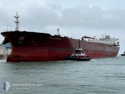
PS GENOVA
Oil Products Tanker
Current Trip
| Time Travelled | 31 days |
|---|---|
| Remaining Time | --- |
| Distance Travelled | 7345.36 nm |
| Remaining Distance | --- |
| AVG Speed | 12.7 Knots |
| MAX Speed | 12.7 Knots |
| AVG Wind | 12.4 knots |
| MAX Wind | 26 knots |
| MIN Temp | 16.5°C / 61.7°F |
| MAX Temp | 34.2°C / 93.56°F |
| Draught | 7.1 m |
| Position Received | 1 d ago |
Current Position
| Longitude | 25.67758° |
|---|---|
| Latitude | 34.27283° |
| Status | Under way using engine |
| Speed | 12.7 Knots |
| Course | 309.1° |
| Area | Mediterranean Sea - Eastern Basin |
| Station | T-AIS |
| Position Received | 1 d ago |
Info
Information
The current position of PS GENOVA is in Mediterranean Sea - Eastern Basin with coordinates 34.27283° / 25.67758° as reported on 2024-06-19 05:29 by AIS to our vessel tracker app. The vessel's current speed is 12.7 Knots and is heading at the port of KALI LIMENES. The estimated time of arrival as calculated by vessel tracking app is 2024-06-19 11:00 LT
The vessel PS GENOVA (IMO: 9439383, MMSI: 229903000) is a Oil Products Tanker that was built in 2010 ( 14 years old ). It's sailing under the flag of [MT] Malta.
In this page you can find informations about the vessels current position, last detected port calls, and current voyage information. If the vessels is not in coverage by AIS you will find the latest position.
The current position of PS GENOVA is detected by our AIS receivers and we are not responsible for the reliability of the data. The last position was recorded while the vessel was in Coverage by the Ais receivers of our vessel tracking app.
The current draught of PS GENOVA as reported by AIS is 7.1 meters
Weather
| Temperature | 25°C / 77°F |
|---|---|
| Wind Speed | 14 knots |
| Direction | 11° N |
| Pressure | 1009.6 hPa |
| Humidity | 72.2 % |
| Cloud Coverage | --- |
Featured Company
Last Port Calls
| Port | Arrival | Departure | Time In Port |
|---|---|---|---|
| 2024-05-17 06:14 | 2024-05-20 14:54 | 3 d | |
| 2024-05-13 18:10 | 2024-05-13 21:35 | 3 h | |
| 2024-05-11 15:15 | 2024-05-13 17:58 | 2 d | |
| 2024-05-11 10:03 | 2024-05-11 14:58 | 4 h | |
| 2024-05-08 13:13 | 2024-05-09 15:10 | 1 d | |
| 2024-04-28 07:37 | 2024-04-30 09:18 | 2 d | |
| 2024-04-15 19:21 | 2024-04-15 20:01 | 40 m | |
| 2024-04-01 13:10 |
Most Visited Ports (Last year)
| Port | Arrivals | |
|---|---|---|
| 4 | ||
| 3 | ||
| 3 | ||
| 2 | ||
| 2 | ||
| 2 |
Last Trips
| Origin | Departure | Destination | Arrival | Distance | |
|---|---|---|---|---|---|
| 2024-05-13 16:35 | 2024-05-17 01:14 | 804.48 nm | |||
| 2024-05-13 12:58 | 2024-05-13 13:10 | 2.12 nm | |||
| 2024-05-11 09:58 | 2024-05-11 10:15 | 2.00 nm | |||
| 2024-05-09 10:10 | 2024-05-11 05:03 | 538.95 nm | |||
| 2024-04-30 04:18 | 2024-05-08 08:13 | 657.03 nm | |||
| 2024-04-15 15:01 | 2024-04-28 02:37 | 895.06 nm | |||
| 2024-04-01 08:10 | 2024-04-15 14:21 | 321.06 nm |
Events
| Time | Event | Details | Position / Dest | Info |
|---|---|---|---|---|
| 2024-06-19 21:21 | START Moving | 1.83 nm, South East of KALI LIMENES |
34.91502 / 24.83510
GRKLL
|
Speed: 8.2 kn Course: 227° |
| 2024-06-19 10:28 | STOP Moving | 1.71 nm, East of KALI LIMENES |
34.92736 / 24.83704
GRKLL
|
Speed: 0.3 kn Course: 143° |
| 2024-06-19 05:35 | Status Changed | Default Under way using engine |
34.28500 / 25.65667
GRKLL
|
Speed: 12.7 kn Course: 309.1° |
| 2024-06-19 05:29 | OUT of Coverage |
34.27283 / 25.67758
Mediterranean Sea - Eastern Basin
GRKLL
|
Speed: 12.7 kn Course: 309.1° |
|
| 2024-06-19 05:12 | Status Changed | Under way using engine Default |
34.23453 / 25.73375
GRKLL
|
Speed: 13 kn Course: 312° |
| 2024-06-19 05:01 | Status Changed | Default Under way using engine |
34.20892 / 25.76939
GRKLL
|
Speed: 13 kn Course: 311.8° |
| 2024-06-19 00:40 | Status Changed | Under way using engine Default |
33.54715 / 26.62452
GRKLL
|
Speed: 13 kn Course: 312° |
| 2024-06-19 00:34 | Status Changed | Default Under way using engine |
33.53364 / 26.64223
GRKLL
|
Speed: 13 kn Course: 312.1° |
| 2024-06-18 23:47 | Change Sea Area | Greek part of the Mediterranean Sea - Eastern Basin Egyptian part of the Mediterranean Sea - Eastern Basin |
33.41805 / 26.79430
Mediterranean Sea - Eastern Basin
GRKLL
|
Speed: 12.9 kn Course: 312.8° |
| 2024-06-18 23:47 | Status Changed | Under way using engine Default |
33.41805 / 26.79430
GRKLL
|
Speed: 13 kn Course: 312° |