
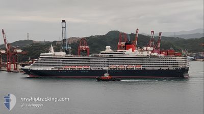
QUEEN ELIZABETH
Passengers Ship
Current Trip
| Time Travelled | 1 day |
|---|---|
| Remaining Time | --- |
| Distance Travelled | 184.79 nm |
| Remaining Distance | 138.54 nm |
| AVG Speed | 9.7 Knots |
| MAX Speed | 11.4 Knots |
| AVG Wind | 4.3 knots |
| MAX Wind | 10.9 knots |
| MIN Temp | 5.4°C / 41.72°F |
| MAX Temp | 12°C / 53.6°F |
| Draught | 8.1 m |
| Position Received | 3 d ago |
Current Position
| Longitude | -129.31595° |
|---|---|
| Latitude | 51.28682° |
| Status | Under way using engine |
| Speed | 17.6 Knots |
| Course | 288.1° |
| Area | The Coastal Waters of Southeast Alaska and British Columbia |
| Station | T-AIS |
| Position Received | 3 d ago |
Info
Information
The current position of QUEEN ELIZABETH is in The Coastal Waters of Southeast Alaska and British Columbia with coordinates 51.28682° / -129.31595° as reported on 2024-06-12 16:09 by AIS to our vessel tracker app. The vessel's current speed is 17.6 Knots and is heading at the port of SITKA. The estimated time of arrival as calculated by vessel tracking app is 2024-06-12 14:25 LT
The vessel QUEEN ELIZABETH (IMO: 9477438, MMSI: 310625000) is a Passengers Ship that was built in 2010 ( 14 years old ). It's sailing under the flag of [BM] Bermuda.
In this page you can find informations about the vessels current position, last detected port calls, and current voyage information. If the vessels is not in coverage by AIS you will find the latest position.
The current position of QUEEN ELIZABETH is detected by our AIS receivers and we are not responsible for the reliability of the data. The last position was recorded while the vessel was in Coverage by the Ais receivers of our vessel tracking app.
The current draught of QUEEN ELIZABETH as reported by AIS is 8.1 meters
Weather
| Temperature | 9.8°C / 49.64°F |
|---|---|
| Wind Speed | 3 knots |
| Direction | 269° W |
| Pressure | 1018.6 hPa |
| Humidity | 91 % |
| Cloud Coverage | 21 % |
Featured Company
Last Port Calls
| Port | Arrival | Departure | Time In Port |
|---|---|---|---|
| 2024-06-14 18:03 | 2024-06-15 03:47 | 9 h | |
| 2024-06-11 13:20 | 2024-06-12 01:05 | 11 h | |
| 2024-06-10 07:49 | 2024-06-11 04:02 | 20 h | |
| 2024-06-04 15:17 | 2024-06-05 01:25 | 10 h | |
| 2024-06-03 13:09 | 2024-06-04 02:01 | 12 h | |
| 2024-05-26 22:25 | 2024-05-27 09:41 | 11 h | |
| 2024-05-25 22:04 | 2024-05-26 08:57 | 10 h | |
| 2024-05-23 19:45 | 2024-05-24 11:29 | 15 h | |
| 2024-05-21 22:01 | 2024-05-22 08:58 | 10 h | |
| 2024-05-20 21:20 | 2024-05-21 08:32 | 11 h |
Last Trips
| Origin | Departure | Destination | Arrival | Distance | |
|---|---|---|---|---|---|
| 2024-06-11 18:05 | 2024-06-14 10:03 | 981.24 nm | |||
| 2024-06-10 21:02 | 2024-06-11 06:20 | 83.70 nm | |||
| 2024-06-04 17:25 | 2024-06-10 00:49 | 1626.41 nm | |||
| 2024-06-03 18:01 | 2024-06-04 07:17 | 194.21 nm | |||
| 2024-05-27 18:41 | 2024-06-03 05:09 | 3174.94 nm | |||
| 2024-05-26 17:57 | 2024-05-27 07:25 | 231.98 nm | |||
| 2024-05-24 20:29 | 2024-05-26 07:04 | 580.41 nm | |||
| 2024-05-22 17:58 | 2024-05-24 04:45 | 516.44 nm | |||
| 2024-05-21 17:32 | 2024-05-22 07:01 | 205.17 nm | |||
| 2024-05-19 18:22 | 2024-05-21 06:20 | 638.87 nm |
Events
| Time | Event | Details | Position / Dest | Info |
|---|---|---|---|---|
| 2024-06-16 04:55 | START Moving | 1.73 nm, North of HOONAH |
58.13867 / -135.46654
SITKA,ALASKA
|
Speed: 4.5 kn Course: 50° |
| 2024-06-15 14:31 | STOP Moving | 1.45 nm, North of HOONAH |
58.13356 / -135.46730
SITKA,ALASKA
|
Speed: 0.1 kn Course: 252° |
| 2024-06-15 03:47 | PORT DEPARTURE |
|
59.44298 / -135.33987
SITKA,ALASKA
|
Speed: 5.1 kn Course: 45° |
| 2024-06-15 03:43 | START Moving |
59.44634 / -135.33330
[US] SKAGWAY
|
Speed: 5.1 kn Course: 45° |
|
| 2024-06-14 18:11 | STOP Moving |
59.44989 / -135.32764
[US] SKAGWAY
|
Speed: 0.2 kn Course: 44° |
|
| 2024-06-14 18:03 | PORT ARRIVAL |
|
59.44814 / -135.33073
[US] SKAGWAY
|
Speed: 4.8 kn Course: 38° |
| 2024-06-14 04:07 | START Moving | 4.81 nm, North West of SITKA |
57.11721 / -135.39723
SITKA,ALASKA
|
Speed: 4 kn Course: 161° |
| 2024-06-13 20:23 | STOP Moving | 4.68 nm, North West of SITKA |
57.11549 / -135.39499
SITKA,ALASKA
|
Speed: 0.2 kn Course: 166° |
| 2024-06-12 16:15 | Status Changed | Default Under way using engine |
51.29481 / -129.35925
SITKA,ALASKA
|
Speed: 17.6 kn Course: 288.1° |
| 2024-06-12 16:09 | OUT of Coverage |
51.28682 / -129.31595
The Coastal Waters of Southeast Alaska and British Columbia
SITKA,ALASKA
|
Speed: 17.6 kn Course: 288.1° |