
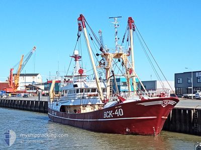
QUO VADIS
Trawler
Current Trip
FISHGROUNDS
| Time Travelled | 2 days |
|---|---|
| Remaining Time | --- |
| Distance Travelled | 143.86 nm |
| Remaining Distance | --- |
| AVG Speed | 6.8 Knots |
| MAX Speed | 10.6 Knots |
| AVG Wind | 17.1 knots |
| MAX Wind | 22.8 knots |
| MIN Temp | 12.4°C / 54.32°F |
| MAX Temp | 13.5°C / 56.3°F |
| Draught | 5.6 m |
| Position Received | 1 d ago |
Current Position
| Longitude | 5.08772° |
|---|---|
| Latitude | 56.76385° |
| Status | Under way sailing |
| Speed | 3.3 Knots |
| Course | 110° |
| Area | North Sea |
| Station | T-AIS |
| Position Received | 1 d ago |
Info
Information
The current position of QUO VADIS is in North Sea with coordinates 56.76385° / 5.08772° as reported on 2024-05-22 04:58 by AIS to our vessel tracker app. The vessel's current speed is 3.3 Knots
The vessel QUO VADIS (IMO: 9101223, MMSI: 235005350) is a Trawler that was built in 1996 ( 28 years old ). It's sailing under the flag of [GB] United Kingdom.
In this page you can find informations about the vessels current position, last detected port calls, and current voyage information. If the vessels is not in coverage by AIS you will find the latest position.
The current position of QUO VADIS is detected by our AIS receivers and we are not responsible for the reliability of the data. The last position was recorded while the vessel was in Coverage by the Ais receivers of our vessel tracking app.
The current draught of QUO VADIS as reported by AIS is 5.6 meters
Weather
| Temperature | 13.2°C / 55.76°F |
|---|---|
| Wind Speed | 22 knots |
| Direction | 86° E |
| Pressure | 1010.6 hPa |
| Humidity | 81.8 % |
| Cloud Coverage | 100 % |
Featured Company
Last Port Calls
| Port | Arrival | Departure | Time In Port |
|---|---|---|---|
| 2024-05-17 12:57 | 2024-05-21 03:34 | 3 d | |
| 2024-05-08 11:15 | 2024-05-13 06:22 | 4 d | |
| 2024-05-03 04:28 | 2024-05-03 06:39 | 2 h | |
| 2024-04-26 08:13 | 2024-04-29 06:24 | 2 d | |
| 2024-04-19 18:42 | 2024-04-22 05:47 | 2 d | |
| 2024-04-12 13:10 | 2024-04-14 23:44 | 2 d | |
| 2024-04-05 21:55 | 2024-04-08 00:08 | 2 d | |
| 2024-03-29 08:27 | 2024-04-01 20:17 | 3 d | |
| 2024-03-23 01:48 | 2024-03-25 01:06 | 1 d | |
| 2024-03-15 23:46 | 2024-03-18 00:57 | 2 d |
Most Visited Ports (Last year)
| Port | Arrivals | |
|---|---|---|
| 13 | ||
| 13 | ||
| 13 | ||
| 6 | ||
| 1 |
Last Trips
| Origin | Departure | Destination | Arrival | Distance | |
|---|---|---|---|---|---|
| 2024-05-13 08:22 | 2024-05-17 14:57 | 455.46 nm | |||
| 2024-05-03 08:39 | 2024-05-08 13:15 | 272.42 nm | |||
| 2024-04-29 08:24 | 2024-05-03 06:28 | 301.47 nm | |||
| 2024-04-22 07:47 | 2024-04-26 10:13 | 184.21 nm | |||
| 2024-04-15 01:44 | 2024-04-19 20:42 | 378.81 nm | |||
| 2024-04-08 02:08 | 2024-04-12 15:10 | 147.70 nm | |||
| 2024-04-01 22:17 | 2024-04-05 23:55 | 147.65 nm | |||
| 2024-03-25 02:06 | 2024-03-29 09:27 | 353.47 nm | |||
| 2024-03-18 01:57 | 2024-03-23 02:48 | 459.23 nm | |||
| 2024-03-11 20:55 | 2024-03-16 00:46 | 377.22 nm |
Events
| Time | Event | Details | Position / Dest | Info |
|---|---|---|---|---|
| 2024-05-22 04:58 | OUT of Coverage |
56.76385 / 5.08772
North Sea
|
Speed: 3.3 kn Course: 111.8° |
|
| 2024-05-22 03:08 | IN Coverage |
56.80856 / 4.92359
North Sea
|
Speed: 3.3 kn Course: 118° |
|
| 2024-05-22 00:27 | OUT of Coverage |
57.08476 / 5.27820
North Sea
|
Speed: 9.4 kn Course: 204.7° |
|
| 2024-05-22 00:16 | IN Coverage |
57.10963 / 5.30050
North Sea
|
Speed: 9.4 kn Course: 206° |
|
| 2024-05-21 23:13 | OUT of Coverage |
57.25426 / 5.42646
North Sea
|
Speed: 8.6 kn Course: 207.6° |
|
| 2024-05-21 13:25 | Change Sea Area | Norwegian part of the North Sea Danish part of the North Sea |
57.04413 / 6.50693
North Sea
|
Speed: 10.3 kn Course: 287.2° |
| 2024-05-21 07:50 | IN Coverage |
57.09274 / 7.14095
North Sea
|
Speed: 9.8 kn Course: 303.2° |
|
| 2024-05-21 06:48 | OUT of Coverage |
57.00100 / 7.40397
North Sea
|
Speed: 10.1 kn Course: 301.6° |
|
| 2024-05-21 03:34 | PORT DEPARTURE |
|
56.70125 / 8.22838
FISHGROUNDS
|
Speed: 9 kn Course: 38° |
| 2024-05-21 03:32 | START Moving |
56.70136 / 8.22401
[DK] THYBORON
|
Speed: 4.7 kn Course: 160° |