
RAM
Not available
Current Trip
Current Position
| Longitude | 5.84435° |
|---|---|
| Latitude | 51.75351° |
| Status | Under way using engine |
| Speed | |
| Course | --- |
| Area | North Sea |
| Station | T-AIS |
| Position Received | Now |
Info
Information
The current position of RAM is in North Sea with coordinates 51.75351° / 5.84435° as reported on 2024-06-03 08:58 by AIS to our vessel tracker app. The vessel's current speed is 0 Knots and is currently inside the port of CUIJK.
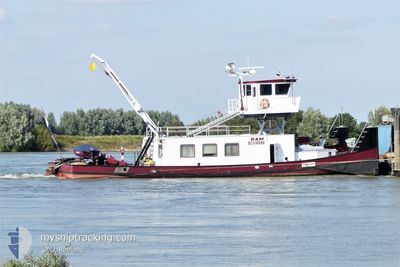
The vessel RAM (MMSI: 244690471) is a Not available It's sailing under the flag of [NL] Netherlands.
In this page you can find informations about the vessels current position, last detected port calls, and current voyage information. If the vessels is not in coverage by AIS you will find the latest position.
The current position of RAM is detected by our AIS receivers and we are not responsible for the reliability of the data. The last position was recorded while the vessel was in Coverage by the Ais receivers of our vessel tracking app.
The current draught of RAM as reported by AIS is 2.2 meters
Weather
| Temperature | 14°C / 57.2°F |
|---|---|
| Wind Speed | 4 knots |
| Direction | 314° NW |
| Pressure | 1020.6 hPa |
| Humidity | 70.2 % |
| Cloud Coverage | 97 % |
Featured Company
Last Port Calls
| Port | Arrival | Departure | Time In Port |
|---|---|---|---|
| 2024-06-01 14:34 | |||
| 2024-06-01 12:29 | |||
| 2024-06-01 12:12 | |||
| 2024-06-01 12:12 | |||
| 2024-06-01 11:33 | |||
| 2024-05-30 15:06 | 2024-06-01 08:27 | 1 d | |
| 2024-05-30 12:52 | |||
| 2024-05-30 11:52 | |||
| 2024-05-30 11:52 | |||
| 2024-05-30 11:26 |
Last Trips
| Origin | Departure | Destination | Arrival | Distance | |
|---|---|---|---|---|---|
| 2024-06-01 14:29 | 2024-06-01 16:34 | 15.32 nm | |||
| 2024-06-01 10:27 | 2024-06-01 14:12 | 16.63 nm | |||
| 2024-06-01 10:27 | 2024-06-01 13:33 | 15.46 nm | |||
| 2024-05-30 14:52 | 2024-05-30 17:06 | 15.18 nm | |||
| 2024-05-30 10:48 | 2024-05-30 13:52 | 15.17 nm | |||
| 2024-05-30 10:48 | 2024-05-30 13:26 | 14.25 nm | |||
| 2024-05-29 12:00 | 2024-05-29 14:28 | 12.49 nm | |||
| 2024-05-29 08:31 | 2024-05-29 11:04 | 14.70 nm | |||
| 2024-05-28 08:39 | 2024-05-28 11:09 | 15.09 nm | |||
| 2024-05-28 05:04 | 2024-05-28 08:01 | 15.96 nm |
Events
| Time | Event | Details | Position / Dest | Info |
|---|---|---|---|---|
| 2024-06-01 14:52 | STOP Moving |
51.75350 / 5.84429
[NL] CUIJK
|
Speed: 0.2 kn Course: 511° |
|
| 2024-06-01 14:49 | START Moving |
51.75506 / 5.84580
[NL] CUIJK
|
Speed: 5.6 kn Course: 260.1° |
|
| 2024-06-01 14:37 | STOP Moving |
51.75525 / 5.84881
[NL] CUIJK
|
Speed: 0.2 kn Course: 511° |
|
| 2024-06-01 14:34 | PORT ARRIVAL |
|
51.75560 / 5.84987
[NL] CUIJK
|
Speed: 2.1 kn Course: 511° |
| 2024-06-01 13:22 | START Moving | 1.85 nm, South East of BOXMEER |
51.64136 / 5.97971
AIJEN/CUIJK
|
Speed: 4.7 kn Course: 301.7° |
| 2024-06-01 13:10 | STOP Moving | 1.95 nm, South East of BOXMEER |
51.64036 / 5.98241
AIJEN/CUIJK
|
Speed: Course: 511° |
| 2024-06-01 12:29 | START Moving | 0.22 nm, North East of MAASHEES |
51.57241 / 6.04184
AIJEN/CUIJK
|
Speed: 4.9 kn Course: 342.7° |
| 2024-06-01 12:29 | PORT DEPARTURE |
|
51.57241 / 6.04184
AIJEN/CUIJK
|
Speed: 1.6 kn Course: 511° |
| 2024-06-01 12:12 | PORT DEPARTURE |
|
51.56130 / 6.05891
AIJEN/CUIJK
|
Speed: Course: 511° |
| 2024-06-01 12:12 | PORT ARRIVAL |
|
51.56130 / 6.05891
[NL] WELL
|
Speed: Course: 511° |