
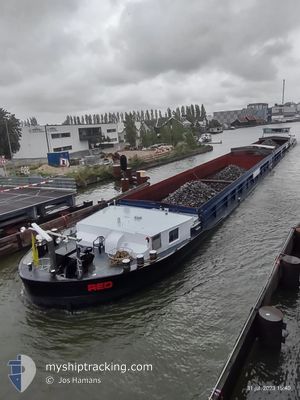
RED
Cargo
Current Position
| Longitude | 10.20913° |
|---|---|
| Latitude | 49.87154° |
| Status | Under way using engine |
| Speed | 5.5 Knots |
| Course | 326.4° |
| Area | North Sea |
| Station | T-AIS |
| Position Received | 10 h, 27 m ago |
Info
Information
The current position of RED is in North Sea with coordinates 49.87154° / 10.20913° as reported on 2024-06-21 10:14 by AIS to our vessel tracker app. The vessel's current speed is 5.5 Knots and is heading at the port of ZEEBRUGGE.
The vessel RED (MMSI: 244790215) is a Cargo It's sailing under the flag of [NL] Netherlands.
In this page you can find informations about the vessels current position, last detected port calls, and current voyage information. If the vessels is not in coverage by AIS you will find the latest position.
The current position of RED is detected by our AIS receivers and we are not responsible for the reliability of the data. The last position was recorded while the vessel was in Coverage by the Ais receivers of our vessel tracking app.
The current draught of RED as reported by AIS is 1.1 meters
Weather
| Temperature | 16.7°C / 62.06°F |
|---|---|
| Wind Speed | 11 knots |
| Direction | 260° W |
| Pressure | 1016.5 hPa |
| Humidity | 96.2 % |
| Cloud Coverage | 100 % |
Featured Company
Last Port Calls
| Port | Arrival | Departure | Time In Port |
|---|---|---|---|
| 2024-06-18 06:56 | |||
| 2024-06-17 19:47 | 2024-06-18 04:48 | 9 h | |
| 2024-06-17 17:53 | 2024-06-17 18:42 | 48 m | |
| 2024-06-17 14:16 | 2024-06-17 14:50 | 33 m | |
| 2024-06-12 10:19 | 2024-06-13 08:00 | 21 h | |
| 2024-06-12 10:07 | |||
| 2024-06-12 04:40 | 2024-06-12 09:12 | 4 h | |
| 2024-06-11 23:40 | 2024-06-12 03:46 | 4 h | |
| 2024-06-06 18:57 | 2024-06-07 05:19 | 10 h | |
| 2024-06-03 05:01 | 2024-06-03 15:56 | 10 h |
Last Trips
| Origin | Departure | Destination | Arrival | Distance | |
|---|---|---|---|---|---|
| 2024-06-18 06:48 | 2024-06-18 08:56 | 8.41 nm | |||
| 2024-06-17 20:42 | 2024-06-17 21:47 | 4.81 nm | |||
| 2024-06-17 16:50 | 2024-06-17 19:53 | 12.25 nm | |||
| 2024-06-13 10:00 | 2024-06-17 16:16 | 169.92 nm | |||
| 2024-06-12 11:12 | 2024-06-12 12:19 | 5.52 nm | |||
| 2024-06-12 11:12 | 2024-06-12 12:07 | 4.96 nm | |||
| 2024-06-12 05:46 | 2024-06-12 06:40 | 2.22 nm | |||
| 2024-06-07 07:19 | 2024-06-12 01:40 | 132.88 nm | |||
| 2024-06-03 17:56 | 2024-06-06 20:57 | 172.59 nm | |||
| 2024-06-02 21:14 | 2024-06-03 07:01 | 42.96 nm |
Events
| Time | Event | Details | Position / Dest | Info |
|---|---|---|---|---|
| 2024-06-21 10:14 | OUT of Coverage |
49.87154 / 10.20913
North Sea
|
Speed: 5.5 kn Course: 326.4° |
|
| 2024-06-21 09:35 | START Moving | 11.58 nm, East of WURZBURG |
49.81974 / 10.22115
ZEEBRUGGE
|
Speed: 3.2 kn Course: 355.1° |
| 2024-06-21 09:11 | STOP Moving | 11.58 nm, East of WURZBURG |
49.81750 / 10.22157
ZEEBRUGGE
|
Speed: 0.3 kn Course: 511° |
| 2024-06-21 08:38 | START Moving | 10.07 nm, East of WURZBURG |
49.79474 / 10.18479
ZEEBRUGGE
|
Speed: 3.5 kn Course: 114.5° |
| 2024-06-21 08:11 | STOP Moving | 9.97 nm, East of WURZBURG |
49.79567 / 10.18216
ZEEBRUGGE
|
Speed: 0.2 kn Course: 511° |
| 2024-06-21 06:57 | START Moving | 10 nm, South East of WURZBURG |
49.72028 / 10.15590
ZEEBRUGGE
|
Speed: 3.6 kn Course: 54.9° |
| 2024-06-21 06:47 | STOP Moving | 9.95 nm, South East of WURZBURG |
49.71917 / 10.15350
ZEEBRUGGE
|
Speed: Course: 511° |
| 2024-06-21 05:37 | IN Coverage |
49.66775 / 10.13115
North Sea
|
Speed: 2.2 kn Course: 88.1° |
|
| 2024-06-21 02:31 | OUT of Coverage |
49.66785 / 10.13029
North Sea
|
Speed: Course: 511° |
|
| 2024-06-21 02:31 | IN Coverage |
49.66785 / 10.13029
North Sea
|
Speed: Course: 511° |