
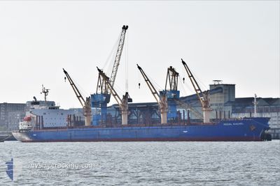
REGAL RACHEL
Bulk Carrier
Current Trip
HOUSTON
| Time Travelled | 11 days |
|---|---|
| Remaining Time | --- |
| Distance Travelled | 2743.51 nm |
| Remaining Distance | --- |
| AVG Speed | 10.6 Knots |
| MAX Speed | 13.6 Knots |
| AVG Wind | 10.4 knots |
| MAX Wind | 22 knots |
| MIN Temp | 26.9°C / 80.42°F |
| MAX Temp | 35.9°C / 96.62°F |
| Draught | 7.3 m |
| Position Received | 9 d ago |
Current Position
| Longitude | 57.29147° |
|---|---|
| Latitude | 24.87935° |
| Status | Under way using engine |
| Speed | 12.3 Knots |
| Course | 110.3° |
| Area | Gulf of Oman |
| Station | T-AIS |
| Position Received | 9 d ago |
Info
Information
The current position of REGAL RACHEL is in Gulf of Oman with coordinates 24.87935° / 57.29147° as reported on 2024-05-31 12:57 by AIS to our vessel tracker app. The vessel's current speed is 12.3 Knots
The vessel REGAL RACHEL (IMO: 9424089, MMSI: 538008602) is a Bulk Carrier that was built in 2010 ( 14 years old ). It's sailing under the flag of [MH] Marshall Is.
In this page you can find informations about the vessels current position, last detected port calls, and current voyage information. If the vessels is not in coverage by AIS you will find the latest position.
The current position of REGAL RACHEL is detected by our AIS receivers and we are not responsible for the reliability of the data. The last position was recorded while the vessel was in Coverage by the Ais receivers of our vessel tracking app.
The current draught of REGAL RACHEL as reported by AIS is 7.3 meters
Weather
| Temperature | 26.9°C / 80.42°F |
|---|---|
| Wind Speed | 21 knots |
| Direction | 159° SSE |
| Pressure | 1013.3 hPa |
| Humidity | 78.6 % |
| Cloud Coverage | 49 % |
Featured Company
Last Port Calls
| Port | Arrival | Departure | Time In Port |
|---|---|---|---|
| 2024-05-20 21:01 | 2024-05-29 09:14 | 8 d | |
| 2024-05-17 01:50 | 2024-05-20 11:43 | 3 d | |
| 2024-05-14 05:37 | 2024-05-16 20:23 | 2 d | |
| 2024-04-06 00:41 | 2024-04-10 14:45 | 4 d |
Last Trips
| Origin | Departure | Destination | Arrival | Distance | |
|---|---|---|---|---|---|
| 2024-05-20 15:43 | 2024-05-21 01:01 | 40.78 nm | |||
| 2024-05-17 00:23 | 2024-05-17 05:50 | 52.92 nm | |||
| 2024-04-10 22:45 | 2024-05-14 09:37 | 6810.11 nm | |||
| 2024-03-05 08:53 | 2024-04-06 08:41 | 6117.35 nm |
Events
| Time | Event | Details | Position / Dest | Info |
|---|---|---|---|---|
| 2024-05-31 13:02 | Status Changed | Default Under way using engine |
24.87346 / 57.30901
HOUSTON
|
Speed: 12.3 kn Course: 110.3° |
| 2024-05-31 12:57 | OUT of Coverage |
24.87935 / 57.29147
Gulf of Oman
|
Speed: 12.3 kn Course: 110.3° |
|
| 2024-05-31 10:43 | Change Sea Area | Omani part of the Gulf of Oman United Arab Emirates part of the Gulf of Oman |
25.04910 / 56.82384
Gulf of Oman
|
Speed: 13.1 kn Course: 113.6° |
| 2024-05-31 10:31 | Destination Changed | HOUSTON FUJAIRAH |
25.06736 / 56.77898
HOUSTON
|
Speed: 13.2 kn Course: 114.8° |
| 2024-05-31 10:31 | ETA Changed | 2024/11/07 05:00 2024/05/30 05:00 |
25.06736 / 56.77898
HOUSTON
|
Speed: 13.2 kn Course: 114.8° |
| 2024-05-31 10:31 | Status Changed | Under way using engine At anchor |
25.06736 / 56.77898
FUJAIRAH
|
Speed: 13.2 kn Course: 114.7° |
| 2024-05-31 08:52 | START Moving | 7.32 nm, East of FUJAIRAH |
25.16744 / 56.49706
FUJAIRAH
|
Speed: 4.2 kn Course: 73° |
| 2024-05-31 06:40 | Status Changed | At anchor Default |
25.16683 / 56.49401
FUJAIRAH
|
Speed: 0.1 kn Course: 140° |
| 2024-05-31 06:37 | Status Changed | Default At anchor |
25.16680 / 56.49400
FUJAIRAH
|
Speed: 0.1 kn Course: 139° |
| 2024-05-31 03:49 | Status Changed | At anchor Default |
25.16556 / 56.49339
FUJAIRAH
|
Speed: 0.1 kn Course: 81° |