
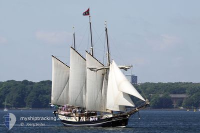
REGINA MARIS
Yacht
Current Trip
| Trip Time | 2 h, 57 mins |
|---|---|
| Trip Distance | 16.33 nm |
| AVG Speed | 6.4 Knots |
| MAX Speed | 8.7 Knots |
| Draught | 2.8 m |
| AVG Wind | 11.2 knots |
| MAX Wind | 12.6 knots |
| MIN Temp | 14°C / 57.2°F |
| MAX Temp | 17.8°C / 64.04°F |
| Position Received | 1 m ago |
Current Position
| Longitude | 10.15737° |
|---|---|
| Latitude | 54.33571° |
| Status | Under way sailing |
| Speed | |
| Course | --- |
| Area | Baltic Sea |
| Station | T-AIS |
| Position Received | 1 m ago |
Info
Information
The current position of REGINA MARIS is in Baltic Sea with coordinates 54.33571° / 10.15737° as reported on 2024-06-16 14:06 by AIS to our vessel tracker app. The vessel's current speed is 0 Knots and is currently inside the port of KIEL.
The vessel REGINA MARIS (IMO: 7025126, MMSI: 244528000) is a Yacht that was built in 1970 ( 54 years old ). It's sailing under the flag of [NL] Netherlands.
In this page you can find informations about the vessels current position, last detected port calls, and current voyage information. If the vessels is not in coverage by AIS you will find the latest position.
The current position of REGINA MARIS is detected by our AIS receivers and we are not responsible for the reliability of the data. The last position was recorded while the vessel was in Coverage by the Ais receivers of our vessel tracking app.
The current draught of REGINA MARIS as reported by AIS is 2.8 meters
Weather
| Temperature | 18.1°C / 64.58°F |
|---|---|
| Wind Speed | 11 knots |
| Direction | 196° SSW |
| Pressure | 1006.8 hPa |
| Humidity | 73.7 % |
| Cloud Coverage | 58 % |
Featured Company
Last Port Calls
| Port | Arrival | Departure | Time In Port |
|---|---|---|---|
| 2024-06-16 11:55 | |||
| 2024-06-15 15:32 | 2024-06-16 08:58 | 17 h | |
| 2024-06-14 10:01 | 2024-06-15 10:53 | 1 d | |
| 2024-06-13 11:50 | 2024-06-14 08:38 | 20 h | |
| 2024-06-12 11:57 | 2024-06-13 08:18 | 20 h | |
| 2024-06-11 14:32 | 2024-06-12 08:38 | 18 h | |
| 2024-06-09 11:49 | 2024-06-10 10:19 | 22 h | |
| 2024-06-08 12:20 | 2024-06-09 08:33 | 20 h | |
| 2024-06-06 11:33 | 2024-06-07 08:24 | 20 h | |
| 2024-06-05 14:06 | 2024-06-06 08:32 | 18 h |
Last Trips
| Origin | Departure | Destination | Arrival | Distance | |
|---|---|---|---|---|---|
| 2024-06-16 10:58 | 2024-06-16 13:55 | 16.33 nm | |||
| 2024-06-15 12:53 | 2024-06-15 17:32 | 33.83 nm | |||
| 2024-06-14 10:38 | 2024-06-14 12:01 | 11.63 nm | |||
| 2024-06-13 10:18 | 2024-06-13 13:50 | 24.88 nm | |||
| 2024-06-12 10:38 | 2024-06-12 13:57 | 22.39 nm | |||
| 2024-06-10 12:19 | 2024-06-11 16:32 | 72.00 nm | |||
| 2024-06-09 10:33 | 2024-06-09 13:49 | 18.81 nm | |||
| 2024-06-07 10:24 | 2024-06-08 14:20 | 71.53 nm | |||
| 2024-06-06 10:32 | 2024-06-06 13:33 | 18.10 nm | |||
| 2024-06-05 10:31 | 2024-06-05 16:06 | 41.93 nm |
Events
| Time | Event | Details | Position / Dest | Info |
|---|---|---|---|---|
| 2024-06-16 12:08 | STOP Moving |
54.33571 / 10.15741
[DE] KIEL
|
Speed: 0.2 kn Course: 511° |
|
| 2024-06-16 11:55 | PORT ARRIVAL |
|
54.36225 / 10.17211
[DE] KIEL
|
Speed: 8.1 kn Course: 194.8° |
| 2024-06-16 08:58 | PORT DEPARTURE |
|
54.47185 / 9.88255
WEATHER DEPENDING
|
Speed: 8.9 kn Course: 75.2° |
| 2024-06-16 08:48 | START Moving |
54.47412 / 9.84532
[DE] ECKERNFOERDE
|
Speed: 9.2 kn Course: 111.2° |
|
| 2024-06-15 15:47 | STOP Moving |
54.47422 / 9.84144
[DE] ECKERNFOERDE
|
Speed: 0.3 kn Course: 511° |
|
| 2024-06-15 15:32 | PORT ARRIVAL |
|
54.47005 / 9.87882
[DE] ECKERNFOERDE
|
Speed: 7.4 kn Course: 257° |
| 2024-06-15 12:52 | Detected in Sea | German part of the Baltic Sea |
54.67681 / 10.29608
Baltic Sea
|
Speed: 7.3 kn Course: 221.2° |
| 2024-06-15 11:34 | Change Sea Area | Danish part of the Baltic Sea Danish part of the Kattegat |
54.79443 / 10.47939
Baltic Sea
|
Speed: 7.2 kn Course: 218° |
| 2024-06-15 10:53 | PORT DEPARTURE |
|
54.85623 / 10.52661
WEATHER DEPENDING
|
Speed: 8 kn Course: 107.7° |
| 2024-06-15 10:53 | START Moving |
54.85645 / 10.52539
[DK] MARSTAL
|
Speed: 7.9 kn Course: 104.2° |