
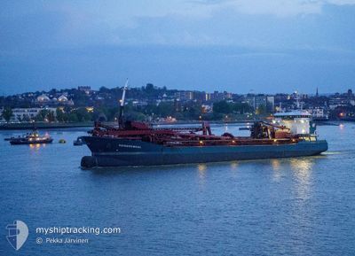
REIMERSWAAL
Trailing Suction Hopper Dredger
Current Trip
| Time Travelled | 1 day |
|---|---|
| Remaining Time | 3 h, 55 mins |
| Distance Travelled | 244.01 nm |
| Remaining Distance | 33.72 nm |
| AVG Speed | 10.1 Knots |
| MAX Speed | 13.7 Knots |
| AVG Wind | 12.8 knots |
| MAX Wind | 23 knots |
| MIN Temp | 8.8°C / 47.84°F |
| MAX Temp | 12.8°C / 55.04°F |
| Draught | 7.8 m |
| Position Received | 1 m ago |
Current Position
| Longitude | 0.78958° |
|---|---|
| Latitude | 51.49961° |
| Status | At anchor |
| Speed | 0.1 Knots |
| Course | 302° |
| Area | North Sea |
| Station | T-AIS |
| Position Received | 1 m ago |
Info
Information
The current position of REIMERSWAAL is in North Sea with coordinates 51.49961° / 0.78958° as reported on 2024-05-04 12:58 by AIS to our vessel tracker app. The vessel's current speed is 0.1 Knots and is heading at the port of LONDON. The estimated time of arrival as calculated by vessel tracking app is 2024-05-04 16:54 LT
The vessel REIMERSWAAL (IMO: 9618240, MMSI: 244116000) is a Trailing Suction Hopper Dredger that was built in 2012 ( 12 years old ). It's sailing under the flag of [NL] Netherlands.
In this page you can find informations about the vessels current position, last detected port calls, and current voyage information. If the vessels is not in coverage by AIS you will find the latest position.
The current position of REIMERSWAAL is detected by our AIS receivers and we are not responsible for the reliability of the data. The last position was recorded while the vessel was in Coverage by the Ais receivers of our vessel tracking app.
The current draught of REIMERSWAAL as reported by AIS is 7.8 meters
Weather
| Temperature | 12.4°C / 54.32°F |
|---|---|
| Wind Speed | 7 knots |
| Direction | 119° ESE |
| Pressure | 1011.4 hPa |
| Humidity | 79.9 % |
| Cloud Coverage | 36 % |
Featured Company
Last Port Calls
| Port | Arrival | Departure | Time In Port |
|---|---|---|---|
| 2024-05-02 15:57 | 2024-05-03 01:17 | 9 h | |
| 2024-05-01 01:11 | 2024-05-01 10:59 | 9 h | |
| 2024-04-26 23:11 | 2024-04-27 06:22 | 7 h | |
| 2024-04-23 21:00 | 2024-04-24 04:38 | 7 h | |
| 2024-04-22 07:49 | 2024-04-22 13:21 | 5 h | |
| 2024-04-19 06:27 | 2024-04-19 12:21 | 5 h | |
| 2024-04-16 10:36 | 2024-04-16 11:31 | 54 m | |
| 2024-04-16 02:19 | 2024-04-16 09:32 | 7 h | |
| 2024-04-13 13:43 | 2024-04-13 19:56 | 6 h | |
| 2024-04-11 22:45 | 2024-04-12 07:33 | 8 h |
Most Visited Ports (Last year)
| Port | Arrivals | |
|---|---|---|
| 49 | ||
| 27 | ||
| 27 | ||
| 19 | ||
| 13 | ||
| 11 |
Last Trips
| Origin | Departure | Destination | Arrival | Distance | |
|---|---|---|---|---|---|
| 2024-05-01 12:59 | 2024-05-02 16:57 | 220.42 nm | |||
| 2024-04-27 07:22 | 2024-05-01 03:11 | 530.23 nm | |||
| 2024-04-24 05:38 | 2024-04-27 00:11 | 474.82 nm | |||
| 2024-04-22 15:21 | 2024-04-23 22:00 | 293.72 nm | |||
| 2024-04-19 13:21 | 2024-04-22 09:49 | 411.30 nm | |||
| 2024-04-16 12:31 | 2024-04-19 07:27 | 520.84 nm | |||
| 2024-04-16 10:32 | 2024-04-16 11:36 | 11.16 nm | |||
| 2024-04-13 20:56 | 2024-04-16 03:19 | 255.51 nm | |||
| 2024-04-12 09:33 | 2024-04-13 14:43 | 227.21 nm | |||
| 2024-04-10 18:59 | 2024-04-12 00:45 | 235.29 nm |
Events
| Time | Event | Details | Position / Dest | Info |
|---|---|---|---|---|
| 2024-05-04 12:46 | Status Changed | At anchor Under way using engine |
51.49984 / .78980
GBLON
|
Speed: 0.1 kn Course: 290° |
| 2024-05-04 12:39 | STOP Moving | 4.03 nm, North East of SHEERNESS |
51.50019 / .78990
GBLON
|
Speed: 0.3 kn Course: 270° |
| 2024-05-04 06:44 | Change Sea Area | United Kingdom part of the North Sea French part of the North Sea |
51.04997 / 1.57794
North Sea
GBLON
|
Speed: 10.6 kn Course: 41.3° |
| 2024-05-04 06:38 | Change Sea Area | French part of the North Sea French part of the English Channel |
51.03708 / 1.56004
North Sea
GBLON
|
Speed: 10.6 kn Course: 41.4° |
| 2024-05-04 04:26 | Destination Changed | GBLON DA458 |
50.72064 / 1.32588
GBLON
|
Speed: 9.4 kn Course: 20.5° |
| 2024-05-04 04:26 | ETA Changed | 2024/05/04 12:00 2024/05/03 20:00 |
50.72064 / 1.32588
GBLON
|
Speed: 9.4 kn Course: 20.5° |
| 2024-05-04 04:23 | Change Sea Area | French part of the English Channel United Kingdom part of the English Channel |
50.71334 / 1.32165
English Channel
|
Speed: 9.2 kn Course: 22.3° |
| 2024-05-04 04:21 | Status Changed | Under way using engine Default |
50.70981 / 1.31868
DA458
|
Speed: 9.6 kn Course: 46° |
| 2024-05-04 04:21 | IN Coverage |
50.71334 / 1.32165
English Channel
|
Speed: 9.2 kn Course: 22.3° |
|
| 2024-05-04 02:01 | OUT of Coverage |
50.52004 / .85915
English Channel
|
Speed: 9.3 kn Course: 85° |