
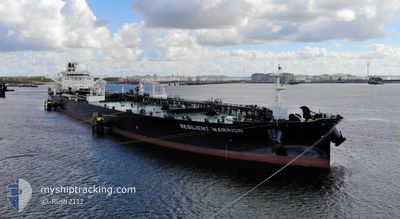
RESILIENT WARRIOR
Tanker
Current Trip
| Trip Time | 78 days |
|---|---|
| Trip Distance | 4898.21 nm |
| AVG Speed | 8.6 Knots |
| MAX Speed | 14.6 Knots |
| Draught | 8 m |
| AVG Wind | 9.8 knots |
| MAX Wind | 29.9 knots |
| MIN Temp | 22°C / 71.6°F |
| MAX Temp | 30.1°C / 86.18°F |
| Position Received | 7 d ago |
Current Position
| Longitude | -79.76146° |
|---|---|
| Latitude | 24.58946° |
| Status | Under way using engine |
| Speed | 11 Knots |
| Course | 209.5° |
| Area | North Atlantic Ocean |
| Station | T-AIS |
| Position Received | 7 d ago |
Info
Information
The current position of RESILIENT WARRIOR is in North Atlantic Ocean with coordinates 24.58946° / -79.76146° as reported on 2024-06-05 07:54 by AIS to our vessel tracker app. The vessel's current speed is 11 Knots and is currently inside the port of INGLESIDE.
The vessel RESILIENT WARRIOR (IMO: 9856359, MMSI: 636019763) is a Tanker It's sailing under the flag of [LR] Liberia.
In this page you can find informations about the vessels current position, last detected port calls, and current voyage information. If the vessels is not in coverage by AIS you will find the latest position.
The current position of RESILIENT WARRIOR is detected by our AIS receivers and we are not responsible for the reliability of the data. The last position was recorded while the vessel was in Coverage by the Ais receivers of our vessel tracking app.
The current draught of RESILIENT WARRIOR as reported by AIS is 8 meters
Weather
| Temperature | 28.5°C / 83.3°F |
|---|---|
| Wind Speed | 9 knots |
| Direction | 156° SSE |
| Pressure | 1010.5 hPa |
| Humidity | 76.8 % |
| Cloud Coverage | 2 % |
Featured Company
Most Visited Ports (Last year)
| Port | Arrivals | |
|---|---|---|
| 3 | ||
| 2 | ||
| 2 | ||
| 1 | ||
| 1 | ||
| 1 |
Last Trips
| Origin | Departure | Destination | Arrival | Distance | |
|---|---|---|---|---|---|
| 2024-03-24 13:24 | 2024-06-10 11:56 | 4898.21 nm |
Events
| Time | Event | Details | Position / Dest | Info |
|---|---|---|---|---|
| 2024-06-10 17:27 | STOP Moving |
27.81979 / -97.20779
[US] INGLESIDE
|
Speed: Course: 202° |
|
| 2024-06-10 16:56 | PORT ARRIVAL |
|
27.81979 / -97.20779
[US] INGLESIDE
|
Speed: 3.6 kn Course: 280° |
| 2024-06-10 14:07 | START Moving | 9.9 nm, East of PORT ARANSAS |
27.83320 / -96.88124
BSFPO FREEPORT
|
Speed: 3.4 kn Course: 215° |
| 2024-06-09 20:15 | STOP Moving | 10.09 nm, East of PORT ARANSAS |
27.84175 / -96.87755
BSFPO FREEPORT
|
Speed: 0.3 kn Course: 137° |
| 2024-06-05 08:11 | Status Changed | Default Under way using engine |
24.54302 / -79.79032
BSFPO FREEPORT
|
Speed: 11 kn Course: 209.5° |
| 2024-06-05 07:54 | Status Changed | Under way using engine Default |
24.58946 / -79.76146
BSFPO FREEPORT
|
Speed: 11.1 kn Course: 209° |
| 2024-06-05 07:54 | IN Coverage |
24.58946 / -79.76146
North Atlantic Ocean
|
Speed: 11 kn Course: 209.5° |
|
| 2024-06-05 07:54 | OUT of Coverage |
24.58946 / -79.76146
North Atlantic Ocean
|
Speed: 11 kn Course: 209.5° |
|
| 2024-06-05 02:55 | Status Changed | Default Under way using engine |
25.43492 / -79.56369
BSFPO FREEPORT
|
Speed: 10.2 kn Course: 186.4° |
| 2024-06-05 02:53 | OUT of Coverage |
25.44151 / -79.56289
North Atlantic Ocean
|
Speed: 10.2 kn Course: 186.4° |