
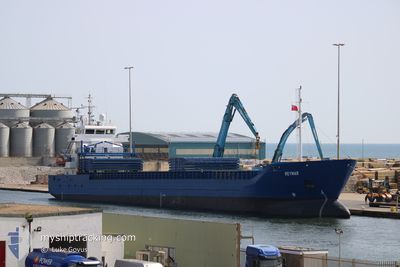
REYMAR
General Cargo
Current Trip
Current Position
| Longitude | 9.31217° |
|---|---|
| Latitude | 54.06666° |
| Status | Under way using engine |
| Speed | 6.9 Knots |
| Course | 196° |
| Area | Baltic Sea |
| Station | T-AIS |
| Position Received | 2 m ago |
Info
Information
The current position of REYMAR is in Baltic Sea with coordinates 54.06666° / 9.31217° as reported on 2024-06-10 14:43 by AIS to our vessel tracker app. The vessel's current speed is 6.9 Knots and is heading at the port of BRAKE. The estimated time of arrival as calculated by vessel tracking app is 2024-06-11 06:24 LT
The vessel REYMAR (IMO: 9552032, MMSI: 212880000) is a General Cargo that was built in 2011 ( 13 years old ). It's sailing under the flag of [CY] Cyprus.
In this page you can find informations about the vessels current position, last detected port calls, and current voyage information. If the vessels is not in coverage by AIS you will find the latest position.
The current position of REYMAR is detected by our AIS receivers and we are not responsible for the reliability of the data. The last position was recorded while the vessel was in Coverage by the Ais receivers of our vessel tracking app.
The current draught of REYMAR as reported by AIS is 6 meters
Weather
| Temperature | 11.6°C / 52.88°F |
|---|---|
| Wind Speed | 5 knots |
| Direction | 209° SSW |
| Pressure | 1004.4 hPa |
| Humidity | 85.4 % |
| Cloud Coverage | 100 % |
Featured Company
Last Port Calls
| Port | Arrival | Departure | Time In Port |
|---|---|---|---|
| 2024-06-05 11:55 | |||
| 2024-05-31 15:14 | 2024-06-03 22:07 | 3 d | |
| 2024-05-28 13:13 | 2024-05-30 18:37 | 2 d | |
| 2024-05-24 14:17 | 2024-05-27 15:02 | 3 d | |
| 2024-05-23 01:09 | 2024-05-23 17:51 | 16 h | |
| 2024-05-21 11:16 | 2024-05-22 11:20 | 1 d | |
| 2024-05-17 19:28 | 2024-05-18 17:12 | 21 h | |
| 2024-05-16 05:16 | 2024-05-17 14:04 | 1 d | |
| 2024-05-13 05:01 | 2024-05-13 21:54 | 16 h | |
| 2024-05-10 00:56 | 2024-05-10 23:24 | 22 h |
Last Trips
| Origin | Departure | Destination | Arrival | Distance | |
|---|---|---|---|---|---|
| 2024-06-04 00:07 | 2024-06-05 14:55 | 447.33 nm | |||
| 2024-05-30 21:37 | 2024-05-31 17:14 | 205.76 nm | |||
| 2024-05-27 17:02 | 2024-05-28 16:13 | 204.39 nm | |||
| 2024-05-23 20:51 | 2024-05-24 16:17 | 205.14 nm | |||
| 2024-05-22 14:20 | 2024-05-23 04:09 | 150.36 nm | |||
| 2024-05-18 20:12 | 2024-05-21 14:16 | 667.80 nm | |||
| 2024-05-17 17:04 | 2024-05-17 22:28 | 59.73 nm | |||
| 2024-05-14 00:54 | 2024-05-16 08:16 | 554.19 nm | |||
| 2024-05-11 02:24 | 2024-05-13 08:01 | 260.87 nm | |||
| 2024-05-08 06:44 | 2024-05-10 03:56 | 450.32 nm |
Events
| Time | Event | Details | Position / Dest | Info |
|---|---|---|---|---|
| 2024-06-10 14:43 | Status Changed | Under way using engine Default |
54.06729 / 9.31247
DEBKE
|
Speed: 6.9 kn Course: 194° |
| 2024-06-10 14:29 | Status Changed | Default Under way using engine |
54.09247 / 9.32575
DEBKE
|
Speed: 6.7 kn Course: 187.7° |
| 2024-06-10 14:24 | Status Changed | Under way using engine Default |
54.10057 / 9.32925
DEBKE
|
Speed: 6.9 kn Course: 175° |
| 2024-06-10 14:12 | Status Changed | Default Under way using engine |
54.12357 / 9.32885
DEBKE
|
Speed: 7.3 kn Course: 205° |
| 2024-06-10 14:07 | Status Changed | Under way using engine Default |
54.13316 / 9.33413
DEBKE
|
Speed: 7.1 kn Course: 212° |
| 2024-06-10 13:49 | Status Changed | Default Under way using engine |
54.14980 / 9.36227
DEBKE
|
Speed: 5 kn Course: 243.8° |
| 2024-06-10 08:32 | START Moving | 1.4 nm, South West of STICKENHΟRN SPORT |
54.36661 / 10.13920
DEBKE
|
Speed: 3.5 kn Course: 284° |
| 2024-06-10 07:57 | STOP Moving | 1.34 nm, South West of STICKENHΟRN SPORT |
54.36620 / 10.14239
DEBKE
|
Speed: 0.3 kn Course: 282° |
| 2024-06-10 05:05 | Change Sea Area | German part of the Baltic Sea Danish part of the Baltic Sea |
54.56559 / 10.55780
Baltic Sea
DEBKE
|
Speed: 9.8 kn Course: 245.4° |
| 2024-06-10 04:14 | Change Sea Area | Danish part of the Baltic Sea German part of the Baltic Sea |
54.58575 / 10.79740
Baltic Sea
DEBKE
|
Speed: 9.4 kn Course: 265.8° |