
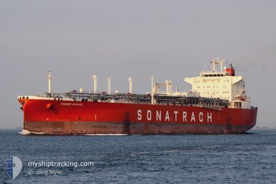
RHOURD ENOUSS
Lpg Tanker
Current Trip
| Trip Time | 4 days |
|---|---|
| Trip Distance | 727.46 nm |
| AVG Speed | 10.7 Knots |
| MAX Speed | 13.1 Knots |
| Draught | 9.5 m |
| AVG Wind | 14.5 knots |
| MAX Wind | 25.2 knots |
| MIN Temp | 16.2°C / 61.16°F |
| MAX Temp | 22°C / 71.6°F |
| Position Received | 1 d ago |
Current Position
| Longitude | 35.76597° |
|---|---|
| Latitude | 36.58233° |
| Status | Under way using engine |
| Speed | 12.5 Knots |
| Course | 48.9° |
| Area | Mediterranean Sea - Eastern Basin |
| Station | T-AIS |
| Position Received | 1 d ago |
Info
Information
The current position of RHOURD ENOUSS is in Mediterranean Sea - Eastern Basin with coordinates 36.58233° / 35.76597° as reported on 2024-05-17 00:32 by AIS to our vessel tracker app. The vessel's current speed is 12.5 Knots and is currently inside the port of DORTYOL.
The vessel RHOURD ENOUSS (IMO: 9284025, MMSI: 636012378) is a Lpg Tanker that was built in 2004 ( 20 years old ). It's sailing under the flag of [LR] Liberia.
In this page you can find informations about the vessels current position, last detected port calls, and current voyage information. If the vessels is not in coverage by AIS you will find the latest position.
The current position of RHOURD ENOUSS is detected by our AIS receivers and we are not responsible for the reliability of the data. The last position was recorded while the vessel was in Coverage by the Ais receivers of our vessel tracking app.
The current draught of RHOURD ENOUSS as reported by AIS is 9.5 meters
Weather
| Temperature | 17.2°C / 62.96°F |
|---|---|
| Wind Speed | 2 knots |
| Direction | 301° WNW |
| Pressure | 1016.4 hPa |
| Humidity | 82.9 % |
| Cloud Coverage | 95 % |
Featured Company
Last Port Calls
Last Trips
| Origin | Departure | Destination | Arrival | Distance | |
|---|---|---|---|---|---|
| 2024-05-12 15:14 | 2024-05-17 07:16 | 727.46 nm | |||
| 2024-05-05 17:46 | 2024-05-11 08:22 | 1498.80 nm | |||
| 2024-04-08 06:41 | 2024-05-03 23:41 | 3477.14 nm | |||
| 2024-03-22 06:08 | 2024-04-05 22:53 | 2365.52 nm | |||
| 2024-03-13 17:36 | 2024-03-20 08:59 | 1860.19 nm | |||
| 2024-02-21 19:03 | 2024-03-12 00:20 | 3096.17 nm |
Events
| Time | Event | Details | Position / Dest | Info |
|---|---|---|---|---|
| 2024-05-17 04:48 | STOP Moving |
36.83531 / 36.13932
[TR] DORTYOL
|
Speed: 0.1 kn Course: 223° |
|
| 2024-05-17 04:16 | PORT ARRIVAL |
|
36.83253 / 36.13934
[TR] DORTYOL
|
Speed: 0.4 kn Course: 329° |
| 2024-05-17 03:29 | START Moving | 1.38 nm, South West of DORTYOL |
36.81872 / 36.12090
TRDYL
|
Speed: 3.9 kn Course: 60° |
| 2024-05-17 02:52 | STOP Moving | 1.76 nm, South West of DORTYOL |
36.81351 / 36.11671
TRDYL
|
Speed: 0.2 kn Course: 19° |
| 2024-05-17 00:36 | Status Changed | Default Under way using engine |
36.59134 / 35.77821
TRDYL
|
Speed: 12.5 kn Course: 48.9° |
| 2024-05-17 00:32 | OUT of Coverage |
36.58233 / 35.76597
Mediterranean Sea - Eastern Basin
TRDYL
|
Speed: 12.5 kn Course: 48.9° |
|
| 2024-05-16 22:07 | Status Changed | Under way using engine Default |
36.30056 / 35.23931
TRDYL
|
Speed: 12.9 kn Course: 60° |
| 2024-05-16 21:59 | Status Changed | Default Under way using engine |
36.28603 / 35.20779
TRDYL
|
Speed: 12.9 kn Course: 60.4° |
| 2024-05-16 21:44 | Status Changed | Under way using engine Default |
36.25846 / 35.14783
TRDYL
|
Speed: 13 kn Course: 60° |
| 2024-05-16 21:44 | IN Coverage |
36.25846 / 35.14783
Mediterranean Sea - Eastern Basin
TRDYL
|
Speed: 13 kn Course: 59.8° |