
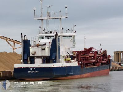
RIO
Trailing Suction Hopper Dredger
Current Trip
DREDGE AREA
| Time Travelled | 13 days |
|---|---|
| Remaining Time | --- |
| Distance Travelled | 868.53 nm |
| Remaining Distance | --- |
| AVG Speed | 7 Knots |
| MAX Speed | 14.1 Knots |
| AVG Wind | 11.6 knots |
| MAX Wind | 24.7 knots |
| MIN Temp | 8.5°C / 47.3°F |
| MAX Temp | 20.4°C / 68.72°F |
| Draught | 5.8 m |
| Position Received | Now |
Current Position
| Longitude | 3.75470° |
|---|---|
| Latitude | 51.38939° |
| Status | Restricted manoeuverability |
| Speed | 0.1 Knots |
| Course | 160° |
| Area | North Sea |
| Station | T-AIS |
| Position Received | Now |
Info
Information
The current position of RIO is in North Sea with coordinates 51.38939° / 3.75470° as reported on 2024-05-29 22:33 by AIS to our vessel tracker app. The vessel's current speed is 0.1 Knots
The vessel RIO (IMO: 8613047, MMSI: 245618000) is a Trailing Suction Hopper Dredger that was built in 1987 ( 37 years old ). It's sailing under the flag of [NL] Netherlands.
In this page you can find informations about the vessels current position, last detected port calls, and current voyage information. If the vessels is not in coverage by AIS you will find the latest position.
The current position of RIO is detected by our AIS receivers and we are not responsible for the reliability of the data. The last position was recorded while the vessel was in Coverage by the Ais receivers of our vessel tracking app.
The current draught of RIO as reported by AIS is 5.8 meters
Weather
| Temperature | 12.5°C / 54.5°F |
|---|---|
| Wind Speed | 7 knots |
| Direction | 233° SW |
| Pressure | 1007 hPa |
| Humidity | 87.6 % |
| Cloud Coverage | 6 % |
Featured Company
Last Port Calls
| Port | Arrival | Departure | Time In Port |
|---|---|---|---|
| 2024-05-16 03:30 | 2024-05-16 09:15 | 5 h | |
| 2024-05-14 02:04 | 2024-05-15 19:42 | 1 d | |
| 2024-05-10 23:54 | 2024-05-13 17:44 | 2 d | |
| 2024-05-10 11:46 | 2024-05-10 17:02 | 5 h | |
| 2024-05-09 23:08 | 2024-05-10 04:12 | 5 h | |
| 2024-05-09 10:56 | 2024-05-09 16:47 | 5 h | |
| 2024-05-08 09:47 | 2024-05-08 10:14 | 27 m | |
| 2024-03-22 08:04 | 2024-05-08 07:58 | ||
| 2024-03-20 11:39 | 2024-03-22 06:49 | 1 d | |
| 2024-03-19 18:01 | 2024-03-20 07:04 | 13 h |
Most Visited Ports (Last year)
| Port | Arrivals | |
|---|---|---|
| 63 | ||
| 26 | ||
| 25 | ||
| 19 | ||
| 7 | ||
| 4 |
Last Trips
| Origin | Departure | Destination | Arrival | Distance | |
|---|---|---|---|---|---|
| 2024-05-15 21:42 | 2024-05-16 05:30 | 49.98 nm | |||
| 2024-05-13 19:44 | 2024-05-14 04:04 | 48.98 nm | |||
| 2024-05-10 19:02 | 2024-05-11 01:54 | 49.34 nm | |||
| 2024-05-10 06:12 | 2024-05-10 13:46 | 49.19 nm | |||
| 2024-05-09 18:47 | 2024-05-10 01:08 | 48.36 nm | |||
| 2024-05-08 12:14 | 2024-05-09 12:56 | 129.92 nm | |||
| 2024-05-08 09:58 | 2024-05-08 11:47 | 11.12 nm | |||
| 2024-03-22 07:49 | 2024-03-22 09:04 | 9.24 nm | |||
| 2024-03-20 08:04 | 2024-03-20 12:39 | 32.53 nm | |||
| 2024-03-19 13:42 | 2024-03-19 19:01 | 33.15 nm |
Events
| Time | Event | Details | Position / Dest | Info |
|---|---|---|---|---|
| 2024-05-29 22:07 | STOP Moving | 1.73 nm, South East of ZEELAND REFINERY |
51.38927 / 3.75502
DREDGE AREA
|
Speed: 0.1 kn Course: 132° |
| 2024-05-29 14:26 | START Moving | 2.19 nm, East of BRESKENS |
51.38759 / 3.62314
DREDGE AREA
|
Speed: 5.3 kn Course: 284.6° |
| 2024-05-29 13:29 | STOP Moving | 2.29 nm, East of BRESKENS |
51.38781 / 3.62606
DREDGE AREA
|
Speed: 0.3 kn Course: 267° |
| 2024-05-29 05:51 | START Moving | 1.64 nm, East of BRESKENS |
51.38797 / 3.60805
DREDGE AREA
|
Speed: 7.8 kn Course: 269.1° |
| 2024-05-29 00:00 | STOP Moving | 1.75 nm, East of BRESKENS |
51.38794 / 3.61114
DREDGE AREA
|
Speed: 0.3 kn Course: 86° |
| 2024-05-28 16:23 | START Moving | 2.14 nm, East of BRESKENS |
51.38799 / 3.62219
DREDGE AREA
|
Speed: 6.8 kn Course: 282° |
| 2024-05-28 13:59 | STOP Moving | 2.26 nm, East of BRESKENS |
51.38745 / 3.62518
DREDGE AREA
|
Speed: 0.3 kn Course: 259° |
| 2024-05-28 13:33 | START Moving | 0.82 nm, South East of BRESKENS |
51.39236 / 3.58736
DREDGE AREA
|
Speed: 3.3 kn Course: 173° |
| 2024-05-28 11:02 | STOP Moving | 0.66 nm, East of BRESKENS |
51.39466 / 3.58404
DREDGE AREA
|
Speed: 0.3 kn Course: 103° |
| 2024-05-28 04:40 | START Moving | 2.14 nm, East of BRESKENS |
51.38721 / 3.62171
DREDGE AREA
|
Speed: 7 kn Course: 268.2° |