
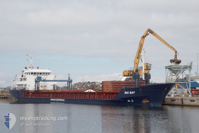
RIX BAY
General Cargo
Current Trip
| Time Travelled | 7 days |
|---|---|
| Remaining Time | --- |
| Distance Travelled | 744.79 nm |
| Remaining Distance | --- |
| AVG Speed | 9.5 Knots |
| MAX Speed | 14.3 Knots |
| AVG Wind | 10.2 knots |
| MAX Wind | 23 knots |
| MIN Temp | 8.9°C / 48.02°F |
| MAX Temp | 22.4°C / 72.32°F |
| Draught | 5.3 m |
| Position Received | 1 m ago |
Current Position
| Longitude | -8.76869° |
|---|---|
| Latitude | 41.15701° |
| Status | At anchor |
| Speed | 0.1 Knots |
| Course | 344° |
| Area | North Atlantic Ocean |
| Station | T-AIS |
| Position Received | 1 m ago |
Info
Information
The current position of RIX BAY is in North Atlantic Ocean with coordinates 41.15701° / -8.76869° as reported on 2024-06-01 02:22 by AIS to our vessel tracker app. The vessel's current speed is 0.1 Knots
The vessel RIX BAY (IMO: 9017410, MMSI: 209974000) is a General Cargo that was built in 1998 ( 26 years old ). It's sailing under the flag of [CY] Cyprus.
In this page you can find informations about the vessels current position, last detected port calls, and current voyage information. If the vessels is not in coverage by AIS you will find the latest position.
The current position of RIX BAY is detected by our AIS receivers and we are not responsible for the reliability of the data. The last position was recorded while the vessel was in Coverage by the Ais receivers of our vessel tracking app.
The current draught of RIX BAY as reported by AIS is 5.3 meters
Weather
| Temperature | 19.7°C / 67.46°F |
|---|---|
| Wind Speed | 14 knots |
| Direction | 70° ENE |
| Pressure | 1010.9 hPa |
| Humidity | 48 % |
| Cloud Coverage | --- |
Featured Company
Last Port Calls
| Port | Arrival | Departure | Time In Port |
|---|---|---|---|
| 2024-05-22 21:42 | 2024-05-25 00:37 | 2 d | |
| 2024-05-09 11:58 | 2024-05-10 12:08 | 1 d | |
| 2024-05-07 03:48 | 2024-05-07 15:41 | 11 h | |
| 2024-05-05 07:54 | 2024-05-06 16:32 | 1 d | |
| 2024-05-04 21:17 | 2024-05-04 21:19 | 1 m | |
| 2024-04-29 15:36 | 2024-05-03 01:01 | 3 d | |
| 2024-04-25 11:18 | 2024-04-25 13:07 | 1 h | |
| 2024-04-18 12:58 | 2024-04-19 13:18 | 1 d | |
| 2024-04-12 06:32 | 2024-04-15 05:23 | 2 d | |
| 2024-04-11 08:08 | 2024-04-11 21:59 | 13 h |
Last Trips
| Origin | Departure | Destination | Arrival | Distance | |
|---|---|---|---|---|---|
| 2024-05-10 15:08 | 2024-05-22 22:42 | 1631.08 nm | |||
| 2024-05-07 17:41 | 2024-05-09 14:58 | 460.43 nm | |||
| 2024-05-06 18:32 | 2024-05-07 05:48 | 107.46 nm | |||
| 2024-05-04 23:19 | 2024-05-05 09:54 | 84.86 nm | |||
| 2024-05-03 03:01 | 2024-05-04 23:17 | 393.01 nm | |||
| 2024-04-25 15:07 | 2024-04-29 17:36 | 11.31 nm | |||
| 2024-04-19 14:18 | 2024-04-25 13:18 | 716.22 nm | |||
| 2024-04-15 07:23 | 2024-04-18 13:58 | 663.86 nm | |||
| 2024-04-11 23:59 | 2024-04-12 08:32 | 73.99 nm | |||
| 2024-04-08 16:07 | 2024-04-11 10:08 | 489.63 nm |
Events
| Time | Event | Details | Position / Dest | Info |
|---|---|---|---|---|
| 2024-06-01 00:03 | ETA Changed | 2025/05/28 03:00 2024/05/28 03:00 |
41.15700 / -8.76868
PTLEI
|
Speed: 0.1 kn Course: 343° |
| 2024-05-31 19:37 | Status Changed | At anchor Default |
41.15685 / -8.76937
PTLEI
|
Speed: 0.2 kn Course: 311° |
| 2024-05-31 19:34 | Status Changed | Default At anchor |
41.15682 / -8.76938
PTLEI
|
Speed: 0.2 kn Course: 1° |
| 2024-05-28 09:49 | Status Changed | At anchor Under way using engine |
41.15700 / -8.76962
PTLEI
|
Speed: 0.9 kn Course: 8° |
| 2024-05-28 09:49 | STOP Moving | 3.31 nm, South West of LEIXOES |
41.15700 / -8.76962
PTLEI
|
Speed: 0.3 kn Course: 359° |
| 2024-05-28 09:49 | Status Changed | Under way using engine At anchor |
41.15735 / -8.76983
PTLEI
|
Speed: 0.6 kn Course: 5° |
| 2024-05-28 09:49 | Status Changed | At anchor Under way using engine |
41.15714 / -8.76973
PTLEI
|
Speed: 0.8 kn Course: 4° |
| 2024-05-28 08:00 | Status Changed | Under way using engine Default |
41.40285 / -8.94156
PTLEI
|
Speed: 10.6 kn Course: 149° |
| 2024-05-28 07:55 | Status Changed | Default Under way using engine |
41.41605 / -8.95201
PTLEI
|
Speed: 10.1 kn Course: 148.8° |
| 2024-05-28 07:50 | Change Sea Area | Portuguese part of the North Atlantic Ocean French part of the Celtic Sea |
41.42773 / -8.96124
North Atlantic Ocean
PTLEI
|
Speed: 10.1 kn Course: 148.8° |