
ROCK.IT
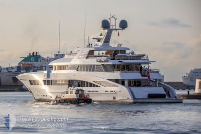
Pleasure Craft
Current Trip
| Trip Time | 10 days |
|---|---|
| Trip Distance | 518.29 nm |
| AVG Speed | 9.4 Knots |
| MAX Speed | 14.4 Knots |
| Draught | 3.3 m |
| AVG Wind | 5.2 knots |
| MAX Wind | 17.6 knots |
| MIN Temp | 18.1°C / 64.58°F |
| MAX Temp | 30.3°C / 86.54°F |
| Position Received | 1 m ago |
Current Position
| Longitude | 7.28807° |
|---|---|
| Latitude | 43.69328° |
| Status | Moored |
| Speed | |
| Course | 199° |
| Area | Mediterranean Sea - Western Basin |
| Station | T-AIS |
| Position Received | 1 m ago |
Info
Information
The current position of ROCK.IT is in Mediterranean Sea - Western Basin with coordinates 43.69328° / 7.28807° as reported on 2024-06-27 13:24 by AIS to our vessel tracker app. The vessel's current speed is 0 Knots and is currently inside the port of NICE.
The vessel ROCK.IT (IMO: 1012347, MMSI: 319072900) is a Pleasure Craft It's sailing under the flag of [KY] Cayman Is.
In this page you can find informations about the vessels current position, last detected port calls, and current voyage information. If the vessels is not in coverage by AIS you will find the latest position.
The current position of ROCK.IT is detected by our AIS receivers and we are not responsible for the reliability of the data. The last position was recorded while the vessel was in Coverage by the Ais receivers of our vessel tracking app.
The current draught of ROCK.IT as reported by AIS is 3.3 meters
Weather
| Temperature | 22.6°C / 72.68°F |
|---|---|
| Wind Speed | 6 knots |
| Direction | 159° SSE |
| Pressure | 1013.3 hPa |
| Humidity | 76 % |
| Cloud Coverage | 73 % |
Featured Company
Last Port Calls
| Port | Arrival | Departure | Time In Port |
|---|---|---|---|
| 2024-06-25 11:11 | |||
| 2024-06-10 10:27 | 2024-06-15 09:54 | 4 d | |
| 2024-05-23 09:12 | 2024-05-27 04:47 | 3 d | |
| 2024-05-21 06:53 | 2024-05-23 04:40 | 1 d | |
| 2024-05-16 13:22 | 2024-05-20 21:40 | 4 d | |
| 2024-05-07 09:01 | 2024-05-16 06:12 | 8 d | |
| 2024-05-07 07:29 |
Most Visited Ports (Last year)
| Port | Arrivals | |
|---|---|---|
| 5 | ||
| 2 | ||
| 2 | ||
| 2 | ||
| 2 | ||
| 2 |
Last Trips
| Origin | Departure | Destination | Arrival | Distance | |
|---|---|---|---|---|---|
| 2024-06-15 11:54 | 2024-06-25 13:11 | 518.29 nm | |||
| 2024-05-27 06:47 | 2024-06-10 12:27 | 631.38 nm | |||
| 2024-05-23 06:40 | 2024-05-23 11:12 | 46.83 nm | |||
| 2024-05-20 23:40 | 2024-05-21 08:53 | 40.38 nm | |||
| 2024-05-16 08:12 | 2024-05-16 15:22 | 91.02 nm | |||
| 2024-05-07 09:29 | 2024-05-07 11:01 | 14.65 nm |
Events
| Time | Event | Details | Position / Dest | Info |
|---|---|---|---|---|
| 2024-06-25 11:29 | Status Changed | Moored Under way using engine |
43.69450 / 7.28553
[FR] NICE
|
Speed: Course: 196° |
| 2024-06-25 11:17 | STOP Moving |
43.69373 / 7.28491
[FR] NICE
|
Speed: 0.2 kn Course: 287° |
|
| 2024-06-25 11:11 | PORT ARRIVAL |
|
43.68912 / 7.29035
[FR] NICE
|
Speed: 5.6 kn Course: 344.5° |
| 2024-06-25 10:42 | START Moving | 0.73 nm, East of SAINTJEAN CAP FERRAT |
43.69338 / 7.35161
NICE
|
Speed: 7.9 kn Course: 124.9° |
| 2024-06-25 10:36 | Destination Changed | NICE JEAN CAP FARRAT |
43.69454 / 7.34777
NICE
|
Speed: 0.2 kn Course: 92° |
| 2024-06-25 10:36 | ETA Changed | 2024/06/25 13:00 2024/06/25 07:00 |
43.69454 / 7.34777
NICE
|
Speed: 0.2 kn Course: 92° |
| 2024-06-25 10:36 | Status Changed | Under way using engine At anchor |
43.69454 / 7.34776
JEAN CAP FARRAT
|
Speed: Course: 94° |
| 2024-06-25 05:34 | Status Changed | At anchor Under way using engine |
43.69462 / 7.34750
JEAN CAP FARRAT
|
Speed: 0.7 kn Course: 101° |
| 2024-06-25 05:26 | STOP Moving | 0.62 nm, East of SAINTJEAN CAP FERRAT |
43.69417 / 7.34875
JEAN CAP FARRAT
|
Speed: 0.2 kn Course: 286° |
| 2024-06-25 05:02 | Destination Changed | JEAN CAP FARRAT NICE |
43.65564 / 7.39809
JEAN CAP FARRAT
|
Speed: 9.5 kn Course: 314.7° |