
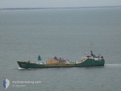
RONEZ
Cement Carrier
Current Trip
| Time Travelled | 19 h, 37 mins |
|---|---|
| Remaining Time | 20 mins |
| Distance Travelled | 206.68 nm |
| Remaining Distance | 5.44 nm |
| AVG Speed | 11.1 Knots |
| MAX Speed | 15.7 Knots |
| AVG Wind | 9.8 knots |
| MAX Wind | 14 knots |
| MIN Temp | 16.2°C / 61.16°F |
| MAX Temp | 17.6°C / 63.68°F |
| Draught | 2.8 m |
| Position Received | Now |
Current Position
| Longitude | 2.06592° |
|---|---|
| Latitude | 51.04419° |
| Status | Under way using engine |
| Speed | 9.2 Knots |
| Course | 79.8° |
| Area | North Sea |
| Station | T-AIS |
| Position Received | Now |
Info
Information
The current position of RONEZ is in North Sea with coordinates 51.04419° / 2.06592° as reported on 2024-06-26 02:48 by AIS to our vessel tracker app. The vessel's current speed is 9.2 Knots and is heading at the port of DUNKERQUE. The estimated time of arrival as calculated by vessel tracking app is 2024-06-26 03:08 LT
The vessel RONEZ (IMO: 8102476, MMSI: 232003642) is a Cement Carrier that was built in 1982 ( 42 years old ). It's sailing under the flag of [GB] United Kingdom.
In this page you can find informations about the vessels current position, last detected port calls, and current voyage information. If the vessels is not in coverage by AIS you will find the latest position.
The current position of RONEZ is detected by our AIS receivers and we are not responsible for the reliability of the data. The last position was recorded while the vessel was in Coverage by the Ais receivers of our vessel tracking app.
The current draught of RONEZ as reported by AIS is 2.8 meters
Weather
| Temperature | 16.2°C / 61.16°F |
|---|---|
| Wind Speed | 6 knots |
| Direction | 35° NE |
| Pressure | 1012.5 hPa |
| Humidity | 95.4 % |
| Cloud Coverage | --- |
Featured Company
Last Port Calls
| Port | Arrival | Departure | Time In Port |
|---|---|---|---|
| 2024-06-24 18:42 | 2024-06-25 07:11 | 12 h | |
| 2024-06-24 05:11 | 2024-06-24 15:36 | 10 h | |
| 2024-06-20 17:01 | 2024-06-22 06:44 | 1 d | |
| 2024-06-17 11:00 | 2024-06-18 07:30 | 20 h | |
| 2024-06-13 16:15 | 2024-06-14 22:50 | 1 d | |
| 2024-06-11 19:33 | 2024-06-12 09:11 | 13 h | |
| 2024-06-11 07:27 | 2024-06-11 15:38 | 8 h | |
| 2024-06-08 13:45 | 2024-06-09 13:22 | 23 h | |
| 2024-06-07 10:43 | 2024-06-07 22:49 | 12 h | |
| 2024-06-04 05:07 | 2024-06-06 17:56 | 2 d |
Last Trips
| Origin | Departure | Destination | Arrival | Distance | |
|---|---|---|---|---|---|
| 2024-06-24 16:36 | 2024-06-24 19:42 | 27.62 nm | |||
| 2024-06-22 07:44 | 2024-06-24 06:11 | 369.89 nm | |||
| 2024-06-18 08:30 | 2024-06-20 18:01 | 596.15 nm | |||
| 2024-06-14 23:50 | 2024-06-17 12:00 | 561.13 nm | |||
| 2024-06-12 10:11 | 2024-06-13 17:15 | 286.33 nm | |||
| 2024-06-11 16:38 | 2024-06-11 20:33 | 27.29 nm | |||
| 2024-06-09 15:22 | 2024-06-11 08:27 | 359.51 nm | |||
| 2024-06-07 23:49 | 2024-06-08 15:45 | 135.55 nm | |||
| 2024-06-06 18:56 | 2024-06-07 11:43 | 139.90 nm | |||
| 2024-05-31 12:48 | 2024-06-04 06:07 | 696.56 nm |
Events
| Time | Event | Details | Position / Dest | Info |
|---|---|---|---|---|
| 2024-06-26 01:02 | Change Sea Area | French part of the North Sea French part of the English Channel |
50.99002 / 1.63464
North Sea
|
Speed: 10.6 kn Course: 48.4° |
| 2024-06-25 21:04 | Status Changed | Under way using engine Default |
50.48252 / .97388
FRDKK
|
Speed: 9.3 kn Course: 62° |
| 2024-06-25 21:02 | Status Changed | Default Under way using engine |
50.47931 / .96579
FRDKK
|
Speed: 9.3 kn Course: 69.1° |
| 2024-06-25 20:46 | Detected in Sea | French part of the English Channel |
50.46615 / .90723
English Channel
|
Speed: 9.2 kn Course: 72.1° |
| 2024-06-25 20:44 | Status Changed | Under way using engine Default |
50.46419 / .89746
FRDKK
|
Speed: 9.3 kn Course: 72° |
| 2024-06-25 20:06 | Status Changed | Default Under way using engine |
50.43470 / .75029
FRDKK
|
Speed: 9.2 kn Course: 71.8° |
| 2024-06-25 20:02 | Status Changed | Under way using engine Default |
50.43198 / .73696
FRDKK
|
Speed: 9.1 kn Course: 73° |
| 2024-06-25 19:41 | Status Changed | Default Under way using engine |
50.41600 / .65913
FRDKK
|
Speed: 8.9 kn Course: 72.9° |
| 2024-06-25 19:36 | Status Changed | Under way using engine Default |
50.41183 / .63790
FRDKK
|
Speed: 8.9 kn Course: 73° |
| 2024-06-25 19:33 | Status Changed | Default Under way using engine |
50.41003 / .62860
FRDKK
|
Speed: 8.8 kn Course: 73.6° |