
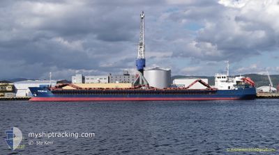
RUSICH-11
General Cargo
Current Trip
| Time Travelled | 5 days |
|---|---|
| Remaining Time | --- |
| Distance Travelled | 621.60 nm |
| Remaining Distance | --- |
| AVG Speed | 7.8 Knots |
| MAX Speed | 11.4 Knots |
| AVG Wind | 6.8 knots |
| MAX Wind | 28 knots |
| MIN Temp | 18.8°C / 65.84°F |
| MAX Temp | 28.6°C / 83.48°F |
| Draught | 4.4 m |
| Position Received | 4 m ago |
Current Position
| Longitude | 28.59913° |
|---|---|
| Latitude | 40.89015° |
| Status | Under way using engine |
| Speed | 8.5 Knots |
| Course | 260.2° |
| Area | Sea of Marmara |
| Station | T-AIS |
| Position Received | 4 m ago |
Info
Information
The current position of RUSICH-11 is in Sea of Marmara with coordinates 40.89015° / 28.59913° as reported on 2024-06-17 10:51 by AIS to our vessel tracker app. The vessel's current speed is 8.5 Knots and is heading at the port of ALIAGA. The estimated time of arrival as calculated by vessel tracking app is 2024-06-18 15:00 LT
The vessel RUSICH-11 (IMO: 9368259, MMSI: 273354040) is a General Cargo that was built in 2007 ( 17 years old ). It's sailing under the flag of [RU] Russia.
In this page you can find informations about the vessels current position, last detected port calls, and current voyage information. If the vessels is not in coverage by AIS you will find the latest position.
The current position of RUSICH-11 is detected by our AIS receivers and we are not responsible for the reliability of the data. The last position was recorded while the vessel was in Coverage by the Ais receivers of our vessel tracking app.
The current draught of RUSICH-11 as reported by AIS is 4.4 meters
Weather
| Temperature | 25.4°C / 77.72°F |
|---|---|
| Wind Speed | 4 knots |
| Direction | 190° S |
| Pressure | 1014.1 hPa |
| Humidity | 52.5 % |
| Cloud Coverage | --- |
Featured Company
Last Port Calls
| Port | Arrival | Departure | Time In Port |
|---|---|---|---|
| 2024-06-10 15:33 | 2024-06-11 16:21 | 1 d | |
| 2024-05-23 05:19 | 2024-05-25 17:29 | 2 d | |
| 2024-05-13 18:04 | 2024-05-17 20:03 | 4 d | |
| 2024-04-30 14:43 | |||
| 2024-04-24 09:56 | 2024-04-26 18:48 | 2 d | |
| 2024-04-11 19:58 | 2024-04-14 02:51 | 2 d | |
| 2024-04-01 13:15 |
Most Visited Ports (Last year)
| Port | Arrivals | |
|---|---|---|
| 11 | ||
| 3 | ||
| 2 | ||
| 2 | ||
| 2 | ||
| 2 |
Last Trips
| Origin | Departure | Destination | Arrival | Distance | |
|---|---|---|---|---|---|
| 2024-05-25 20:29 | 2024-06-10 18:33 | 1165.39 nm | |||
| 2024-05-17 23:03 | 2024-05-23 08:19 | 866.10 nm | |||
| 2024-04-26 21:48 | 2024-05-13 21:04 | 1225.90 nm | |||
| 2024-04-26 21:48 | 2024-04-30 17:43 | 508.87 nm | |||
| 2024-04-14 05:51 | 2024-04-24 12:56 | 817.74 nm | |||
| 2024-04-01 16:15 | 2024-04-11 22:58 | 883.95 nm |
Events
| Time | Event | Details | Position / Dest | Info |
|---|---|---|---|---|
| 2024-06-17 06:19 | Change Sea Area | Turkish part of the Sea of Marmara Turkish part of the Black Sea |
41.23044 / 29.12662
Sea of Marmara
TR ALI
|
Speed: 7.7 kn Course: 181.5° |
| 2024-06-17 05:21 | ETA Changed | 2024/06/18 15:00 2024/06/18 09:00 |
41.26983 / 29.04926
TR ALI
|
Speed: 4.5 kn Course: 68° |
| 2024-06-17 05:14 | START Moving | 3.95 nm, North West of RUMELI FENERI |
41.26940 / 29.04183
TR ALI
|
Speed: 3.1 kn Course: 100° |
| 2024-06-17 05:09 | Status Changed | Under way using engine At anchor |
41.27005 / 29.03890
TR ALI
|
Speed: 0.3 kn Course: 95° |
| 2024-06-17 04:59 | Status Changed | At anchor Default |
41.27009 / 29.03761
TR ALI
|
Speed: Course: 73° |
| 2024-06-17 04:56 | Status Changed | Default At anchor |
41.26997 / 29.03742
TR ALI
|
Speed: Course: 71° |
| 2024-06-17 04:35 | Status Changed | At anchor Default |
41.26995 / 29.03739
TR ALI
|
Speed: Course: 81° |
| 2024-06-17 04:32 | Status Changed | Default At anchor |
41.26996 / 29.03738
TR ALI
|
Speed: Course: 81° |
| 2024-06-17 04:05 | Status Changed | At anchor Default |
41.26989 / 29.03738
TR ALI
|
Speed: Course: 72° |
| 2024-06-17 03:59 | Status Changed | Default At anchor |
41.26987 / 29.03739
TR ALI
|
Speed: Course: 70° |