
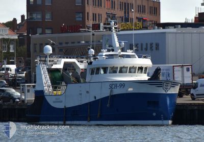
SCH-99 ARAVIS
Fishing
Current Trip
FISHING GROUNDS
| Time Travelled | 1 day |
|---|---|
| Remaining Time | --- |
| Distance Travelled | 178.37 nm |
| Remaining Distance | --- |
| AVG Speed | 8.4 Knots |
| MAX Speed | 11.2 Knots |
| AVG Wind | 6.8 knots |
| MAX Wind | 18.8 knots |
| MIN Temp | 14.9°C / 58.82°F |
| MAX Temp | 22.2°C / 71.96°F |
| Draught | 4.8 m |
| Position Received | Now |
Current Position
| Longitude | 3.89852° |
|---|---|
| Latitude | 52.18753° |
| Status | Under way using engine |
| Speed | 10.8 Knots |
| Course | 83.8° |
| Area | North Sea |
| Station | T-AIS |
| Position Received | Now |
Info
Information
The current position of SCH-99 ARAVIS is in North Sea with coordinates 52.18753° / 3.89852° as reported on 2024-06-27 18:04 by AIS to our vessel tracker app. The vessel's current speed is 10.8 Knots
The vessel SCH-99 ARAVIS (IMO: 9917268, MMSI: 244682000) is a Fishing It's sailing under the flag of [NL] Netherlands.
In this page you can find informations about the vessels current position, last detected port calls, and current voyage information. If the vessels is not in coverage by AIS you will find the latest position.
The current position of SCH-99 ARAVIS is detected by our AIS receivers and we are not responsible for the reliability of the data. The last position was recorded while the vessel was in Coverage by the Ais receivers of our vessel tracking app.
The current draught of SCH-99 ARAVIS as reported by AIS is 4.8 meters
Weather
| Temperature | 17°C / 62.6°F |
|---|---|
| Wind Speed | 19 knots |
| Direction | 233° SW |
| Pressure | 1007.7 hPa |
| Humidity | 83.8 % |
| Cloud Coverage | 76 % |
Featured Company
Last Port Calls
| Port | Arrival | Departure | Time In Port |
|---|---|---|---|
| 2024-06-25 19:38 | 2024-06-25 20:08 | 29 m | |
| 2024-06-21 12:35 | 2024-06-23 21:59 | 2 d | |
| 2024-06-21 02:26 | 2024-06-21 12:11 | 9 h | |
| 2024-06-13 22:53 | 2024-06-16 20:43 | 2 d | |
| 2024-06-07 00:00 | 2024-06-09 20:42 | 2 d | |
| 2024-05-31 08:12 | 2024-06-02 21:36 | 2 d | |
| 2024-05-24 01:05 | 2024-05-31 07:30 | 7 d | |
| 2024-05-22 21:00 | 2024-05-22 21:38 | 38 m | |
| 2024-05-16 17:25 | 2024-05-19 23:16 | 3 d | |
| 2024-05-09 17:55 | 2024-05-13 00:19 | 3 d |
Most Visited Ports (Last year)
| Port | Arrivals | |
|---|---|---|
| 45 | ||
| 10 | ||
| 3 |
Last Trips
| Origin | Departure | Destination | Arrival | Distance | |
|---|---|---|---|---|---|
| 2024-06-23 23:59 | 2024-06-25 21:38 | 183.91 nm | |||
| 2024-06-21 14:11 | 2024-06-21 14:35 | 3.98 nm | |||
| 2024-06-16 22:43 | 2024-06-21 04:26 | 125.84 nm | |||
| 2024-06-09 22:42 | 2024-06-14 00:53 | 53.79 nm | |||
| 2024-06-02 23:36 | 2024-06-07 02:00 | 82.29 nm | |||
| 2024-05-31 09:30 | 2024-05-31 10:12 | 6.49 nm | |||
| 2024-05-22 23:38 | 2024-05-24 03:05 | 149.68 nm | |||
| 2024-05-20 01:16 | 2024-05-22 23:00 | 235.25 nm | |||
| 2024-05-13 02:19 | 2024-05-16 19:25 | 130.26 nm | |||
| 2024-05-06 01:19 | 2024-05-09 19:55 | 170.82 nm |
Events
| Time | Event | Details | Position / Dest | Info |
|---|---|---|---|---|
| 2024-06-27 14:51 | Change Sea Area | Dutch part of the North Sea United Kingdom part of the North Sea |
52.49030 / 3.28486
North Sea
|
Speed: 9.5 kn Course: 136.3° |
| 2024-06-27 14:50 | IN Coverage |
52.49030 / 3.28486
North Sea
|
Speed: 9.5 kn Course: 136.3° |
|
| 2024-06-27 13:03 | OUT of Coverage |
52.69157 / 2.92871
North Sea
|
Speed: 10 kn Course: 130.9° |
|
| 2024-06-27 11:52 | IN Coverage |
52.77655 / 2.79515
North Sea
|
Speed: 1.1 kn Course: 155° |
|
| 2024-06-27 01:33 | OUT of Coverage |
52.75664 / 2.76850
North Sea
|
Speed: 0.8 kn Course: 316.8° |
|
| 2024-06-27 01:33 | IN Coverage |
52.75664 / 2.76850
North Sea
|
Speed: 0.8 kn Course: 316.8° |
|
| 2024-06-27 00:05 | OUT of Coverage |
52.73480 / 2.83350
North Sea
|
Speed: 1.7 kn Course: 300.9° |
|
| 2024-06-26 18:35 | START Moving |
52.82505 / 2.78867
FISHING GROUNDS
|
Speed: 4.6 kn Course: 343° |
|
| 2024-06-26 18:09 | STOP Moving |
52.81699 / 2.78671
FISHING GROUNDS
|
Speed: 0.1 kn Course: 356° |
|
| 2024-06-26 17:04 | START Moving |
52.79457 / 2.73152
FISHING GROUNDS
|
Speed: 3.6 kn Course: 9° |