
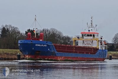
SCHILLPLATE
General Cargo
Current Trip
TO ORDER
| Time Travelled | 1 day |
|---|---|
| Remaining Time | --- |
| Distance Travelled | 197.40 nm |
| Remaining Distance | --- |
| AVG Speed | 10.3 Knots |
| MAX Speed | 11.2 Knots |
| AVG Wind | 16.5 knots |
| MAX Wind | 26.8 knots |
| MIN Temp | 18°C / 64.4°F |
| MAX Temp | 20.8°C / 69.44°F |
| Draught | 4 m |
| Position Received | 7 h, 18 m ago |
Current Position
| Longitude | 2.41127° |
|---|---|
| Latitude | 40.72000° |
| Status | Under way using engine |
| Speed | 10.7 Knots |
| Course | 216° |
| Area | Balearic Sea |
| Station | T-AIS |
| Position Received | 7 h, 18 m ago |
Info
Information
The current position of SCHILLPLATE is in Balearic Sea with coordinates 40.72000° / 2.41127° as reported on 2024-06-01 06:36 by AIS to our vessel tracker app. The vessel's current speed is 10.7 Knots
The vessel SCHILLPLATE (IMO: 9505285, MMSI: 236111603) is a General Cargo that was built in 2009 ( 15 years old ). It's sailing under the flag of [GI] Gibraltar.
In this page you can find informations about the vessels current position, last detected port calls, and current voyage information. If the vessels is not in coverage by AIS you will find the latest position.
The current position of SCHILLPLATE is detected by our AIS receivers and we are not responsible for the reliability of the data. The last position was recorded while the vessel was in Coverage by the Ais receivers of our vessel tracking app.
The current draught of SCHILLPLATE as reported by AIS is 4 meters
Weather
| Temperature | 18.7°C / 65.66°F |
|---|---|
| Wind Speed | 3 knots |
| Direction | 33° NNE |
| Pressure | 1017.2 hPa |
| Humidity | 69.4 % |
| Cloud Coverage | 99 % |
Featured Company
Last Trips
| Origin | Departure | Destination | Arrival | Distance | |
|---|---|---|---|---|---|
| 2024-05-12 18:33 | 2024-05-18 20:20 | 1428.79 nm | |||
| 2024-05-02 18:52 | 2024-05-11 07:45 | 1131.13 nm | |||
| 2024-04-24 06:52 | 2024-05-02 06:13 | 1587.18 nm | |||
| 2024-04-08 15:29 | 2024-04-19 06:46 | 2407.86 nm | |||
| 2024-03-15 19:03 | 2024-04-07 10:00 | 740.52 nm |
Events
| Time | Event | Details | Position / Dest | Info |
|---|---|---|---|---|
| 2024-06-01 06:36 | OUT of Coverage |
40.72000 / 2.41127
Balearic Sea
|
Speed: 10.7 kn Course: 216° |
|
| 2024-06-01 06:01 | Detected in Sea | Spanish part of the Balearic Sea |
40.80131 / 2.49138
Balearic Sea
|
Speed: 10 kn Course: 217.5° |
| 2024-06-01 06:00 | Status Changed | Under way using engine Default |
40.80434 / 2.49438
TO ORDER
|
Speed: 9.9 kn Course: 218° |
| 2024-06-01 06:00 | IN Coverage |
40.80131 / 2.49138
Balearic Sea
|
Speed: 10 kn Course: 217.5° |
|
| 2024-05-31 11:14 | PORT DEPARTURE |
|
43.38963 / 4.92562
TO ORDER
|
Speed: 8.8 kn Course: 125° |
| 2024-05-31 10:58 | START Moving |
43.38790 / 4.88519
[FR] FOS
|
Speed: 3.1 kn Course: 10° |
|
| 2024-05-28 10:16 | Status Changed | Default At anchor |
43.38637 / 4.88819
[FR] FOS
|
Speed: Course: 342° |
| 2024-05-28 10:13 | OUT of Coverage |
43.38625 / 4.88810
Mediterranean Sea - Western Basin
[FR] FOS
|
Speed: Course: 71° |
|
| 2024-05-28 09:01 | Status Changed | At anchor Default |
43.38622 / 4.88799
[FR] FOS
|
Speed: Course: 335° |
| 2024-05-28 08:49 | IN Coverage |
43.38622 / 4.88799
Mediterranean Sea - Western Basin
[FR] FOS
|
Speed: Course: 222° |