
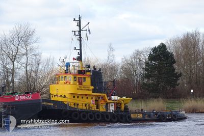
SCHWARTENBEK
Tug
Current Trip
| Time Travelled | 12 h, 47 mins |
|---|---|
| Remaining Time | 6 h, 18 mins |
| Distance Travelled | 83.78 nm |
| Remaining Distance | 46.53 nm |
| AVG Speed | 6.6 Knots |
| MAX Speed | 8.9 Knots |
| AVG Wind | 6 knots |
| MAX Wind | 11 knots |
| MIN Temp | 14.8°C / 58.64°F |
| MAX Temp | 18.9°C / 66.02°F |
| Draught | 2.8 m |
| Position Received | Now |
Current Position
| Longitude | 11.23728° |
|---|---|
| Latitude | 54.57786° |
| Status | Under way using engine |
| Speed | 8.1 Knots |
| Course | 293.8° |
| Area | Baltic Sea |
| Station | T-AIS |
| Position Received | Now |
Info
Information
The current position of SCHWARTENBEK is in Baltic Sea with coordinates 54.57786° / 11.23728° as reported on 2024-06-29 16:22 by AIS to our vessel tracker app. The vessel's current speed is 8.1 Knots and is heading at the port of KIEL. The estimated time of arrival as calculated by vessel tracking app is 2024-06-29 22:41 LT
The vessel SCHWARTENBEK (IMO: 8865652, MMSI: 246832000) is a Tug that was built in 1968 ( 56 years old ). It's sailing under the flag of [NL] Netherlands.
In this page you can find informations about the vessels current position, last detected port calls, and current voyage information. If the vessels is not in coverage by AIS you will find the latest position.
The current position of SCHWARTENBEK is detected by our AIS receivers and we are not responsible for the reliability of the data. The last position was recorded while the vessel was in Coverage by the Ais receivers of our vessel tracking app.
The current draught of SCHWARTENBEK as reported by AIS is 2.8 meters
Weather
| Temperature | 18.9°C / 66.02°F |
|---|---|
| Wind Speed | 8 knots |
| Direction | 90° E |
| Pressure | 1014.5 hPa |
| Humidity | 66.9 % |
| Cloud Coverage | 80 % |
Featured Company
Last Port Calls
| Port | Arrival | Departure | Time In Port |
|---|---|---|---|
| 2024-06-29 03:26 | 2024-06-29 03:36 | 10 m | |
| 2024-06-26 02:14 | 2024-06-26 04:47 | 2 h | |
| 2024-06-15 12:10 | 2024-06-25 18:59 | 10 d | |
| 2024-06-15 07:58 | 2024-06-15 09:22 | 1 h | |
| 2024-06-15 00:02 | 2024-06-15 00:38 | 35 m | |
| 2024-06-06 08:29 | 2024-06-14 06:58 | 7 d | |
| 2024-06-05 21:07 | 2024-06-05 21:47 | 39 m | |
| 2024-06-04 23:06 | 2024-06-04 23:50 | 44 m | |
| 2024-06-04 05:33 | 2024-06-04 06:12 | 39 m | |
| 2024-06-03 09:23 | 2024-06-03 09:52 | 29 m |
Most Visited Ports (Last year)
| Port | Arrivals | |
|---|---|---|
| 36 | ||
| 21 | ||
| 13 | ||
| 9 | ||
| 9 | ||
| 6 |
Last Trips
| Origin | Departure | Destination | Arrival | Distance | |
|---|---|---|---|---|---|
| 2024-06-26 06:47 | 2024-06-29 05:26 | 182.69 nm | |||
| 2024-06-25 20:59 | 2024-06-26 04:14 | 51.53 nm | |||
| 2024-06-15 11:22 | 2024-06-15 14:10 | 17.39 nm | |||
| 2024-06-15 02:38 | 2024-06-15 09:58 | 74.14 nm | |||
| 2024-06-14 08:58 | 2024-06-15 02:02 | 91.63 nm | |||
| 2024-06-05 23:47 | 2024-06-06 10:29 | 91.92 nm | |||
| 2024-06-05 01:50 | 2024-06-05 23:07 | 130.20 nm | |||
| 2024-06-04 08:12 | 2024-06-05 01:06 | 130.19 nm | |||
| 2024-06-03 11:52 | 2024-06-04 07:33 | 129.57 nm | |||
| 2024-06-03 06:43 | 2024-06-03 11:23 | 31.06 nm |
Events
| Time | Event | Details | Position / Dest | Info |
|---|---|---|---|---|
| 2024-06-29 15:55 | Change Sea Area | German part of the Baltic Sea Danish part of the Baltic Sea |
54.55931 / 11.33503
Baltic Sea
KIEL
|
Speed: 7.3 kn Course: 283.2° |
| 2024-06-29 11:34 | Change Sea Area | Danish part of the Baltic Sea German part of the Baltic Sea |
54.44638 / 12.15177
Baltic Sea
KIEL
|
Speed: 6.6 kn Course: 250.5° |
| 2024-06-29 11:13 | Change Sea Area | German part of the Baltic Sea Danish part of the Baltic Sea |
54.47681 / 12.19080
Baltic Sea
KIEL
|
Speed: 7 kn Course: 193.8° |
| 2024-06-29 10:37 | Change Sea Area | Danish part of the Baltic Sea German part of the Baltic Sea |
54.53054 / 12.25038
Baltic Sea
KIEL
|
Speed: 6.9 kn Course: 252.3° |
| 2024-06-29 05:30 | START Moving | 1.43 nm, North East of BARHOFT |
54.44647 / 13.06677
KIEL
|
Speed: 5.6 kn Course: 18.3° |
| 2024-06-29 04:41 | STOP Moving | 0.54 nm, North East of BARHOFT |
54.43934 / 13.04421
KIEL
|
Speed: 0.2 kn Course: 297° |
| 2024-06-29 03:36 | PORT DEPARTURE |
|
54.31913 / 13.10553
KIEL
|
Speed: 5.2 kn Course: 60° |
| 2024-06-29 03:29 | Destination Changed | KIEL DESTL |
54.31117 / 13.10731
[DE] STRALSUND
|
Speed: 5.3 kn Course: 322° |
| 2024-06-29 03:29 | ETA Changed | 2024/06/30 01:00 2024/06/27 08:00 |
54.31117 / 13.10731
[DE] STRALSUND
|
Speed: 5.3 kn Course: 322° |
| 2024-06-29 03:26 | PORT ARRIVAL |
|
54.30766 / 13.11150
[DE] STRALSUND
|
Speed: 5.1 kn Course: 328.1° |