
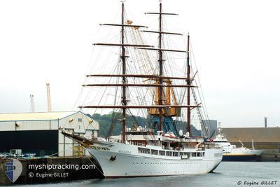
SEA CLOUD II
Passengers Ship
Current Trip
| Time Travelled | 1 day |
|---|---|
| Remaining Time | 56 mins |
| Distance Travelled | 272.76 nm |
| Remaining Distance | 7.09 nm |
| AVG Speed | 6.9 Knots |
| MAX Speed | 11.6 Knots |
| AVG Wind | 10.6 knots |
| MAX Wind | 17.9 knots |
| MIN Temp | 20.8°C / 69.44°F |
| MAX Temp | 23.8°C / 74.84°F |
| Draught | 6 m |
| Position Received | 1 m ago |
Current Position
| Longitude | 12.38767° |
|---|---|
| Latitude | 38.02676° |
| Status | Under way using engine |
| Speed | 6.9 Knots |
| Course | 110° |
| Area | Tyrrhenian Sea |
| Station | T-AIS |
| Position Received | 1 m ago |
Info
Information
The current position of SEA CLOUD II is in Tyrrhenian Sea with coordinates 38.02676° / 12.38767° as reported on 2024-06-26 04:39 by AIS to our vessel tracker app. The vessel's current speed is 6.9 Knots and is heading at the port of TRAPANI. The estimated time of arrival as calculated by vessel tracking app is 2024-06-26 05:36 LT
The vessel SEA CLOUD II (IMO: 9171292, MMSI: 248953000) is a Passengers Ship that was built in 2000 ( 24 years old ). It's sailing under the flag of [MT] Malta.
In this page you can find informations about the vessels current position, last detected port calls, and current voyage information. If the vessels is not in coverage by AIS you will find the latest position.
The current position of SEA CLOUD II is detected by our AIS receivers and we are not responsible for the reliability of the data. The last position was recorded while the vessel was in Coverage by the Ais receivers of our vessel tracking app.
The current draught of SEA CLOUD II as reported by AIS is 6 meters
Weather
| Temperature | 22.4°C / 72.32°F |
|---|---|
| Wind Speed | 5 knots |
| Direction | 343° NNW |
| Pressure | 1011.3 hPa |
| Humidity | 75.7 % |
| Cloud Coverage | 94 % |
Featured Company
Last Port Calls
| Port | Arrival | Departure | Time In Port |
|---|---|---|---|
| 2024-06-24 05:09 | 2024-06-24 17:17 | 12 h | |
| 2024-06-23 05:06 | 2024-06-23 12:00 | 6 h | |
| 2024-06-22 05:34 | 2024-06-22 20:06 | 14 h | |
| 2024-06-21 05:54 | 2024-06-21 11:15 | 5 h | |
| 2024-06-20 05:45 | 2024-06-20 16:10 | 10 h | |
| 2024-06-19 05:46 | 2024-06-19 13:03 | 7 h | |
| 2024-06-17 05:13 | 2024-06-17 17:17 | 12 h | |
| 2024-06-16 10:15 | 2024-06-16 16:07 | 5 h | |
| 2024-06-12 05:23 | 2024-06-12 16:33 | 11 h | |
| 2024-06-10 05:04 | 2024-06-10 17:32 | 12 h |
Last Trips
| Origin | Departure | Destination | Arrival | Distance | |
|---|---|---|---|---|---|
| 2024-06-23 14:00 | 2024-06-24 07:09 | 94.57 nm | |||
| 2024-06-22 22:06 | 2024-06-23 07:06 | 38.03 nm | |||
| 2024-06-21 13:15 | 2024-06-22 07:34 | 105.61 nm | |||
| 2024-06-20 18:10 | 2024-06-21 07:54 | 81.42 nm | |||
| 2024-06-19 15:03 | 2024-06-20 07:45 | 78.51 nm | |||
| 2024-06-17 19:17 | 2024-06-19 07:46 | 211.62 nm | |||
| 2024-06-16 18:07 | 2024-06-17 07:13 | 89.48 nm | |||
| 2024-06-12 18:33 | 2024-06-16 12:15 | 374.33 nm | |||
| 2024-06-10 19:32 | 2024-06-12 07:23 | 179.11 nm | |||
| 2024-06-09 13:01 | 2024-06-10 07:04 | 134.74 nm |
Events
| Time | Event | Details | Position / Dest | Info |
|---|---|---|---|---|
| 2024-06-26 01:38 | Change Sea Area | Italian part of the Tyrrhenian Sea Italian part of the Mediterranean Sea - Western Basin |
37.85726 / 12.24489
Tyrrhenian Sea
IT TPS
|
Speed: 6 kn Course: 343.3° |
| 2024-06-26 00:20 | Change Sea Area | Italian part of the Mediterranean Sea - Western Basin Italian part of the Mediterranean Sea - Eastern Basin |
37.73156 / 12.28913
Mediterranean Sea - Western Basin
IT TPS
|
Speed: 5.9 kn Course: 348.7° |
| 2024-06-25 21:48 | Status Changed | Under way using engine Default |
37.49261 / 12.27779
IT TPS
|
Speed: 9.8 kn Course: 14° |
| 2024-06-25 21:33 | Status Changed | Default Under way using engine |
37.45453 / 12.26558
IT TPS
|
Speed: 9.7 kn Course: 9.2° |
| 2024-06-25 20:53 | ETA Changed | 2024/06/26 05:30 2024/06/26 06:00 |
37.34592 / 12.26196
IT TPS
|
Speed: 9.5 kn Course: 358.7° |
| 2024-06-25 20:43 | Status Changed | Under way using engine Default |
37.31878 / 12.26222
IT TPS
|
Speed: 9.3 kn Course: 359° |
| 2024-06-25 20:43 | IN Coverage |
37.31971 / 12.26219
Mediterranean Sea - Eastern Basin
IT TPS
|
Speed: 9.5 kn Course: 358.9° |
|
| 2024-06-25 11:03 | Status Changed | Default Under way sailing |
37.12131 / 12.35695
IT TPS
|
Speed: 4.7 kn Course: 214° |
| 2024-06-25 10:57 | OUT of Coverage |
37.12841 / 12.36154
Mediterranean Sea - Eastern Basin
IT TPS
|
Speed: 4.7 kn Course: 207.9° |
|
| 2024-06-25 10:54 | Status Changed | Under way sailing Default |
37.13266 / 12.36443
IT TPS
|
Speed: 4.8 kn Course: 214° |