
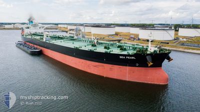
SEA PEARL
Tanker
Current Trip
VNTHO
| Time Travelled | --- |
|---|---|
| Remaining Time | --- |
| Distance Travelled | 7499.33 nm |
| Remaining Distance | --- |
| AVG Speed | 11.7 Knots |
| MAX Speed | 15.6 Knots |
| AVG Wind | 14.5 knots |
| MAX Wind | 29 knots |
| MIN Temp | 18.8°C / 65.84°F |
| MAX Temp | 29.1°C / 84.38°F |
| Draught | 20.5 m |
| Position Received | 2 d ago |
Current Position
| Longitude | 77.46874° |
|---|---|
| Latitude | 7.35803° |
| Status | Under way using engine |
| Speed | 13.6 Knots |
| Course | 122.5° |
| Area | Laccadive Sea |
| Station | T-AIS |
| Position Received | 2 d ago |
Info
Information
The current position of SEA PEARL is in Laccadive Sea with coordinates 7.35803° / 77.46874° as reported on 2024-06-23 22:19 by AIS to our vessel tracker app. The vessel's current speed is 13.6 Knots
The vessel SEA PEARL (IMO: 9779604, MMSI: 241465000) is a Tanker It's sailing under the flag of [GR] Greece.
In this page you can find informations about the vessels current position, last detected port calls, and current voyage information. If the vessels is not in coverage by AIS you will find the latest position.
The current position of SEA PEARL is detected by our AIS receivers and we are not responsible for the reliability of the data. The last position was recorded while the vessel was in Coverage by the Ais receivers of our vessel tracking app.
The current draught of SEA PEARL as reported by AIS is 20.5 meters
Weather
| Temperature | 28.2°C / 82.76°F |
|---|---|
| Wind Speed | 16 knots |
| Direction | 217° SW |
| Pressure | 1005.3 hPa |
| Humidity | 80 % |
| Cloud Coverage | 100 % |
Featured Company
Last Port Calls
Last Trips
| Origin | Departure | Destination | Arrival | Distance |
|---|
Events
| Time | Event | Details | Position / Dest | Info |
|---|---|---|---|---|
| 2024-06-23 22:25 | Status Changed | Default Under way using engine |
7.34668 / 77.48566
VNTHO
|
Speed: 13.6 kn Course: 122.5° |
| 2024-06-23 22:19 | OUT of Coverage |
7.35803 / 77.46874
Laccadive Sea
VNTHO
|
Speed: 13.6 kn Course: 122.5° |
|
| 2024-06-23 19:35 | Status Changed | Under way using engine Default |
7.70934 / 76.93998
VNTHO
|
Speed: 13.8 kn Course: 123° |
| 2024-06-23 19:31 | Status Changed | Default Under way using engine |
7.71754 / 76.92692
VNTHO
|
Speed: 13.8 kn Course: 121.6° |
| 2024-06-23 17:38 | Detected in Sea | Indian part of the Laccadive Sea |
7.94560 / 76.57175
Laccadive Sea
VNTHO
|
Speed: 13.4 kn Course: 122.7° |
| 2024-06-23 17:38 | Status Changed | Under way using engine Default |
7.94560 / 76.57175
VNTHO
|
Speed: 13.2 kn Course: 122° |
| 2024-06-23 17:21 | IN Coverage |
7.94560 / 76.57175
Laccadive Sea
VNTHO
|
Speed: 13.4 kn Course: 122.7° |
|
| 2024-06-19 02:21 | Status Changed | Default Under way using engine |
24.77781 / 57.28825
VNTHO
|
Speed: 14.7 kn Course: 126° |
| 2024-06-19 02:16 | OUT of Coverage |
24.79058 / 57.26910
Gulf of Oman
VNTHO
|
Speed: 14.7 kn Course: 126° |
|
| 2024-06-19 00:31 | Change Sea Area | Omani part of the Gulf of Oman United Arab Emirates part of the Gulf of Oman |
25.07033 / 56.97455
Gulf of Oman
VNTHO
|
Speed: 14.6 kn Course: 175.1° |