
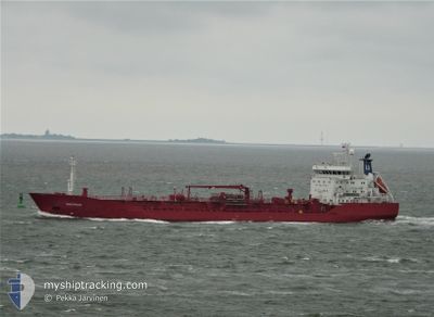
SEA PROSPECT
General Cargo
Current Trip
| Time Travelled | 16 h, 23 mins |
|---|---|
| Remaining Time | --- |
| Distance Travelled | 151.63 nm |
| Remaining Distance | --- |
| AVG Speed | 8.9 Knots |
| MAX Speed | 11.7 Knots |
| AVG Wind | 17.8 knots |
| MAX Wind | 22 knots |
| MIN Temp | 9.6°C / 49.28°F |
| MAX Temp | 13°C / 55.4°F |
| Draught | 8.3 m |
| Position Received | 1 h, 15 m ago |
Current Position
| Longitude | 5.10106° |
|---|---|
| Latitude | 53.57572° |
| Status | Under way using engine |
| Speed | 11.1 Knots |
| Course | 251° |
| Area | North Sea |
| Station | T-AIS |
| Position Received | 1 h, 15 m ago |
Info
Information
The current position of SEA PROSPECT is in North Sea with coordinates 53.57572° / 5.10106° as reported on 2024-06-11 14:26 by AIS to our vessel tracker app. The vessel's current speed is 11.1 Knots and is heading at the port of SFAX. The estimated time of arrival as calculated by vessel tracking app is 2024-06-20 12:00 LT
The vessel SEA PROSPECT (IMO: 9516143, MMSI: 257222000) is a General Cargo that was built in 2012 ( 12 years old ). It's sailing under the flag of [NO] Norway.
In this page you can find informations about the vessels current position, last detected port calls, and current voyage information. If the vessels is not in coverage by AIS you will find the latest position.
The current position of SEA PROSPECT is detected by our AIS receivers and we are not responsible for the reliability of the data. The last position was recorded while the vessel was in Coverage by the Ais receivers of our vessel tracking app.
The current draught of SEA PROSPECT as reported by AIS is 8.3 meters
Weather
| Temperature | 12.8°C / 55.04°F |
|---|---|
| Wind Speed | 16 knots |
| Direction | 313° NW |
| Pressure | 1013.9 hPa |
| Humidity | 72.9 % |
| Cloud Coverage | 100 % |
Featured Company
Last Port Calls
| Port | Arrival | Departure | Time In Port |
|---|---|---|---|
| 2024-06-10 21:16 | 2024-06-10 23:18 | 2 h | |
| 2024-06-10 10:58 | 2024-06-10 12:18 | 1 h | |
| 2024-06-04 17:43 | 2024-06-07 14:29 | 2 d | |
| 2024-05-31 07:31 | 2024-06-01 17:28 | 1 d | |
| 2024-05-23 10:43 | 2024-05-23 19:27 | 8 h | |
| 2024-05-20 09:50 | 2024-05-21 13:45 | 1 d | |
| 2024-05-18 11:53 | 2024-05-19 09:29 | 21 h | |
| 2024-05-04 10:00 | 2024-05-08 04:16 | 3 d | |
| 2024-05-03 07:34 | 2024-05-03 08:40 | 1 h | |
| 2024-04-30 08:38 | 2024-04-30 09:17 | 38 m |
Most Visited Ports (Last year)
| Port | Arrivals | |
|---|---|---|
| 5 | ||
| 4 | ||
| 4 | ||
| 3 | ||
| 3 | ||
| 3 |
Last Trips
| Origin | Departure | Destination | Arrival | Distance | |
|---|---|---|---|---|---|
| 2024-06-10 14:18 | 2024-06-10 23:16 | 49.57 nm | |||
| 2024-06-07 17:29 | 2024-06-10 12:58 | 713.49 nm | |||
| 2024-06-01 19:28 | 2024-06-04 20:43 | 862.81 nm | |||
| 2024-05-23 21:27 | 2024-05-31 09:31 | 2105.50 nm | |||
| 2024-05-21 14:45 | 2024-05-23 12:43 | 411.23 nm | |||
| 2024-05-19 10:29 | 2024-05-20 10:50 | 278.13 nm | |||
| 2024-05-08 06:16 | 2024-05-18 12:53 | 2651.45 nm | |||
| 2024-05-03 10:40 | 2024-05-04 12:00 | 265.92 nm | |||
| 2024-04-30 11:17 | 2024-05-03 09:34 | 49.29 nm | |||
| 2024-04-27 08:23 | 2024-04-30 10:38 | 624.22 nm |
Events
| Time | Event | Details | Position / Dest | Info |
|---|---|---|---|---|
| 2024-06-11 14:43 | Status Changed | Default Under way using engine |
53.55912 / 5.01730
TNSFA
|
Speed: 11.1 kn Course: 251° |
| 2024-06-11 14:26 | OUT of Coverage |
53.57572 / 5.10106
North Sea
TNSFA
|
Speed: 11.1 kn Course: 251° |
|
| 2024-06-11 14:10 | Status Changed | Under way using engine Default |
53.59139 / 5.18045
TNSFA
|
Speed: 10 kn Course: 254° |
| 2024-06-11 14:10 | IN Coverage |
53.59139 / 5.18045
North Sea
TNSFA
|
Speed: 10.9 kn Course: 253.3° |
|
| 2024-06-11 13:12 | Status Changed | Default Under way using engine |
53.64287 / 5.45225
TNSFA
|
Speed: 10 kn Course: 251.5° |
| 2024-06-11 13:07 | OUT of Coverage |
53.64742 / 5.47469
North Sea
TNSFA
|
Speed: 10 kn Course: 251.5° |
|
| 2024-06-11 12:36 | Status Changed | Under way using engine Default |
53.67481 / 5.61433
TNSFA
|
Speed: 9.7 kn Course: 254° |
| 2024-06-11 12:17 | Status Changed | Default Under way using engine |
53.69031 / 5.69653
TNSFA
|
Speed: 9.6 kn Course: 252.6° |
| 2024-06-11 11:51 | Status Changed | Under way using engine Default |
53.71072 / 5.80540
TNSFA
|
Speed: 9.1 kn Course: 256° |
| 2024-06-11 11:49 | Change Sea Area | Dutch part of the North Sea German part of the North Sea |
53.71232 / 5.81517
North Sea
TNSFA
|
Speed: 9.4 kn Course: 253.6° |