
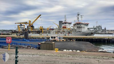
SEBASTIANO CABOTO
Trailing Suction Hopper Dredger
Current Trip
| Time Travelled | 11 days |
|---|---|
| Remaining Time | --- |
| Distance Travelled | 293.70 nm |
| Remaining Distance | --- |
| AVG Speed | 7.6 Knots |
| MAX Speed | 10.6 Knots |
| AVG Wind | 8.3 knots |
| MAX Wind | 17.8 knots |
| MIN Temp | 29.9°C / 85.82°F |
| MAX Temp | 36.7°C / 98.06°F |
| Draught | 3.1 m |
| Position Received | 1 m ago |
Current Position
| Longitude | 54.93113° |
|---|---|
| Latitude | 24.96565° |
| Status | At anchor |
| Speed | 0.2 Knots |
| Course | 358° |
| Area | Persian Gulf |
| Station | T-AIS |
| Position Received | 1 m ago |
Info
Information
The current position of SEBASTIANO CABOTO is in Persian Gulf with coordinates 24.96565° / 54.93113° as reported on 2024-06-16 14:56 by AIS to our vessel tracker app. The vessel's current speed is 0.2 Knots
The vessel SEBASTIANO CABOTO (IMO: 9505364, MMSI: 253336000) is a Trailing Suction Hopper Dredger that was built in 2011 ( 13 years old ). It's sailing under the flag of [LU] Luxembourg.
In this page you can find informations about the vessels current position, last detected port calls, and current voyage information. If the vessels is not in coverage by AIS you will find the latest position.
The current position of SEBASTIANO CABOTO is detected by our AIS receivers and we are not responsible for the reliability of the data. The last position was recorded while the vessel was in Coverage by the Ais receivers of our vessel tracking app.
The current draught of SEBASTIANO CABOTO as reported by AIS is 3.1 meters
Weather
| Temperature | 33.6°C / 92.48°F |
|---|---|
| Wind Speed | 14 knots |
| Direction | 349° N |
| Pressure | 998.8 hPa |
| Humidity | 60.6 % |
| Cloud Coverage | --- |
Featured Company
Most Visited Ports (Last year)
| Port | Arrivals | |
|---|---|---|
| 3 | ||
| 1 | ||
| 1 | ||
| 1 |
Events
| Time | Event | Details | Position / Dest | Info |
|---|---|---|---|---|
| 2024-06-16 13:17 | Status Changed | At anchor Default |
24.96575 / 54.93100
DUBAI WATERFRONT
|
Speed: Course: 8° |
| 2024-06-16 13:09 | Status Changed | Default At anchor |
24.96575 / 54.93100
DUBAI WATERFRONT
|
Speed: Course: 8° |
| 2024-06-16 04:02 | Status Changed | At anchor Default |
24.96610 / 54.93109
DUBAI WATERFRONT
|
Speed: Course: 54° |
| 2024-06-16 03:56 | Status Changed | Default At anchor |
24.96609 / 54.93112
DUBAI WATERFRONT
|
Speed: Course: 54° |
| 2024-06-15 22:08 | Status Changed | At anchor Default |
24.96613 / 54.93095
DUBAI WATERFRONT
|
Speed: Course: 70° |
| 2024-06-15 21:59 | Status Changed | Default At anchor |
24.96615 / 54.93098
DUBAI WATERFRONT
|
Speed: Course: 81° |
| 2024-06-15 13:23 | Status Changed | At anchor Default |
24.96603 / 54.93148
DUBAI WATERFRONT
|
Speed: 0.3 kn Course: 333° |
| 2024-06-15 13:17 | Status Changed | Default At anchor |
24.96609 / 54.93142
DUBAI WATERFRONT
|
Speed: 0.1 kn Course: 353° |
| 2024-06-15 11:35 | Status Changed | At anchor Default |
24.96654 / 54.93150
DUBAI WATERFRONT
|
Speed: 0.2 kn Course: 41° |
| 2024-06-15 11:32 | Status Changed | Default At anchor |
24.96656 / 54.93134
DUBAI WATERFRONT
|
Speed: 0.1 kn Course: 1° |