
SENATA
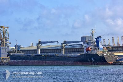
Bulk Carrier
Current Trip
| Time Travelled | 13 days |
|---|---|
| Remaining Time | --- |
| Distance Travelled | 2475.35 nm |
| Remaining Distance | --- |
| AVG Speed | 8.6 Knots |
| MAX Speed | 11.1 Knots |
| AVG Wind | 14.8 knots |
| MAX Wind | 26 knots |
| MIN Temp | 10.6°C / 51.08°F |
| MAX Temp | 19.9°C / 67.82°F |
| Draught | 8.2 m |
| Position Received | 18 h, 34 m ago |
Current Position
| Longitude | -8.66879° |
|---|---|
| Latitude | 33.19874° |
| Status | At anchor |
| Speed | 0.1 Knots |
| Course | 11° |
| Area | North Atlantic Ocean |
| Station | T-AIS |
| Position Received | 18 h, 34 m ago |
Info
Information
The current position of SENATA is in North Atlantic Ocean with coordinates 33.19874° / -8.66879° as reported on 2024-06-02 00:24 by AIS to our vessel tracker app. The vessel's current speed is 0.1 Knots
The vessel SENATA (IMO: 9451575, MMSI: 636013823) is a Bulk Carrier that was built in 2008 ( 16 years old ). It's sailing under the flag of [LR] Liberia.
In this page you can find informations about the vessels current position, last detected port calls, and current voyage information. If the vessels is not in coverage by AIS you will find the latest position.
The current position of SENATA is detected by our AIS receivers and we are not responsible for the reliability of the data. The last position was recorded while the vessel was in Coverage by the Ais receivers of our vessel tracking app.
The current draught of SENATA as reported by AIS is 8.2 meters
Weather
| Temperature | 19.7°C / 67.46°F |
|---|---|
| Wind Speed | 10 knots |
| Direction | 324° NW |
| Pressure | 1012.9 hPa |
| Humidity | 88.2 % |
| Cloud Coverage | 47 % |
Featured Company
Events
| Time | Event | Details | Position / Dest | Info |
|---|---|---|---|---|
| 2024-06-02 00:31 | Status Changed | Default At anchor |
33.19833 / -8.66833
MA JFL
|
Speed: 0.1 kn Course: 11° |
| 2024-06-02 00:24 | Status Changed | At anchor Default |
33.19874 / -8.66879
MA JFL
|
Speed: Course: -1° |
| 2024-06-02 00:24 | IN Coverage |
33.19874 / -8.66879
North Atlantic Ocean
MA JFL
|
Speed: 0.1 kn Course: 173.1° |
|
| 2024-06-02 00:24 | OUT of Coverage |
33.19874 / -8.66879
North Atlantic Ocean
|
Speed: 0.1 kn Course: 173.1° |
|
| 2024-06-01 19:01 | STOP Moving | 4.54 nm, North West of JORF LASFAR |
33.19833 / -8.66833
MA JFL
|
Speed: Course: -1° |
| 2024-06-01 13:28 | Status Changed | Default Under way using engine |
34.01294 / -8.74988
MA JFL
|
Speed: 9.8 kn Course: 175.8° |
| 2024-06-01 13:20 | OUT of Coverage |
34.03477 / -8.75169
North Atlantic Ocean
MA JFL
|
Speed: 9.8 kn Course: 175.8° |
|
| 2024-06-01 13:20 | Detected in Sea | Moroccan part of the North Atlantic Ocean |
34.03569 / -8.75177
North Atlantic Ocean
MA JFL
|
Speed: 9.8 kn Course: 176.4° |
| 2024-06-01 13:20 | Status Changed | Under way using engine Default |
34.03569 / -8.75177
MA JFL
|
Speed: 9.8 kn Course: 176° |
| 2024-06-01 13:16 | IN Coverage |
34.03569 / -8.75177
North Atlantic Ocean
MA JFL
|
Speed: 9.8 kn Course: 176.4° |