
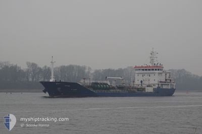
SEYMA
Oil/Chemical Tanker
Current Trip
| Time Travelled | 4 days |
|---|---|
| Remaining Time | --- |
| Distance Travelled | 672.63 nm |
| Remaining Distance | --- |
| AVG Speed | 10.2 Knots |
| MAX Speed | 12.7 Knots |
| AVG Wind | 10.4 knots |
| MAX Wind | 18 knots |
| MIN Temp | 11.3°C / 52.34°F |
| MAX Temp | 16.4°C / 61.52°F |
| Draught | 6.3 m |
| Position Received | 1 d ago |
Current Position
| Longitude | -4.84856° |
|---|---|
| Latitude | 53.31589° |
| Status | Under way using engine |
| Speed | 11.7 Knots |
| Course | 21.7° |
| Area | Irish Sea and St. George's Channel |
| Station | T-AIS |
| Position Received | 1 d ago |
Info
Information
The current position of SEYMA is in Irish Sea and St. George's Channel with coordinates 53.31589° / -4.84856° as reported on 2024-05-16 04:34 by AIS to our vessel tracker app. The vessel's current speed is 11.7 Knots
The vessel SEYMA (IMO: 9596777, MMSI: 229546000) is a Oil/Chemical Tanker that was built in 2013 ( 11 years old ). It's sailing under the flag of [MT] Malta.
In this page you can find informations about the vessels current position, last detected port calls, and current voyage information. If the vessels is not in coverage by AIS you will find the latest position.
The current position of SEYMA is detected by our AIS receivers and we are not responsible for the reliability of the data. The last position was recorded while the vessel was in Coverage by the Ais receivers of our vessel tracking app.
The current draught of SEYMA as reported by AIS is 6.3 meters
Weather
| Temperature | 12.1°C / 53.78°F |
|---|---|
| Wind Speed | 2 knots |
| Direction | 302° WNW |
| Pressure | 1014 hPa |
| Humidity | 90.3 % |
| Cloud Coverage | 26 % |
Featured Company
Last Port Calls
| Port | Arrival | Departure | Time In Port |
|---|---|---|---|
| 2024-05-12 11:09 | 2024-05-13 15:32 | 1 d | |
| 2024-05-07 09:38 | 2024-05-08 11:04 | 1 d | |
| 2024-05-07 07:25 | 2024-05-07 08:31 | 1 h | |
| 2024-05-04 21:43 | 2024-05-07 06:58 | 2 d | |
| 2024-05-04 20:20 | 2024-05-04 21:15 | 54 m | |
| 2024-05-04 07:20 | 2024-05-04 17:17 | 9 h | |
| 2024-04-25 17:39 | 2024-04-26 22:35 | 1 d | |
| 2024-04-18 21:01 | 2024-04-21 12:36 | 2 d | |
| 2024-04-14 01:29 | 2024-04-15 04:34 | 1 d | |
| 2024-04-12 11:21 | 2024-04-12 11:23 | 2 m |
Most Visited Ports (Last year)
| Port | Arrivals | |
|---|---|---|
| 28 | ||
| 15 | ||
| 12 | ||
| 4 | ||
| 3 | ||
| 3 |
Last Trips
| Origin | Departure | Destination | Arrival | Distance | |
|---|---|---|---|---|---|
| 2024-05-08 12:04 | 2024-05-12 13:09 | 788.63 nm | |||
| 2024-05-07 09:31 | 2024-05-07 10:38 | 6.57 nm | |||
| 2024-05-07 07:58 | 2024-05-07 08:25 | 1.90 nm | |||
| 2024-05-04 22:15 | 2024-05-04 22:43 | 1.48 nm | |||
| 2024-04-26 23:35 | 2024-05-04 21:20 | 850.39 nm | |||
| 2024-04-26 23:35 | 2024-05-04 08:20 | 819.89 nm | |||
| 2024-04-21 14:36 | 2024-04-25 18:39 | 247.76 nm | |||
| 2024-04-15 07:34 | 2024-04-18 23:01 | 831.86 nm | |||
| 2024-04-12 13:23 | 2024-04-14 04:29 | 411.30 nm | |||
| 2024-04-10 21:34 | 2024-04-12 13:21 | 365.19 nm |
Events
| Time | Event | Details | Position / Dest | Info |
|---|---|---|---|---|
| 2024-05-16 07:54 | STOP Moving | 15.63 nm, North West of CONWY |
53.42010 / -4.21633
GB SOW
|
Speed: 0.3 kn Course: 134° |
| 2024-05-16 04:40 | Status Changed | Default Under way using engine |
53.33333 / -4.83500
GB SOW
|
Speed: 11.7 kn Course: 21.7° |
| 2024-05-16 04:34 | OUT of Coverage |
53.31589 / -4.84856
Irish Sea and St. George's Channel
GB SOW
|
Speed: 11.7 kn Course: 21.7° |
|
| 2024-05-16 03:55 | Change Sea Area | United Kingdom part of the Irish Sea and St. George's Channel United Kingdom part of the English Channel |
53.19833 / -4.92921
Irish Sea and St. George's Channel
GB SOW
|
Speed: 12.2 kn Course: 22.6° |
| 2024-05-16 03:55 | Status Changed | Under way using engine Default |
53.19833 / -4.92921
GB SOW
|
Speed: 12.2 kn Course: 23° |
| 2024-05-16 03:46 | IN Coverage |
53.19833 / -4.92921
Irish Sea and St. George's Channel
GB SOW
|
Speed: 12.2 kn Course: 22.6° |
|
| 2024-05-15 04:19 | Status Changed | Default Under way using engine |
49.91800 / -4.56519
GB SOW
|
Speed: 10.5 kn Course: 266.4° |
| 2024-05-15 04:18 | Status Changed | Under way using engine Default |
49.91809 / -4.56292
GB SOW
|
Speed: 10.6 kn Course: 267° |
| 2024-05-15 04:18 | OUT of Coverage |
49.91809 / -4.56292
English Channel
GB SOW
|
Speed: 10.5 kn Course: 266.4° |
|
| 2024-05-15 03:59 | Status Changed | Default Under way using engine |
49.92213 / -4.47451
GB SOW
|
Speed: 10.4 kn Course: 264.9° |