
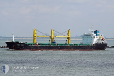
SIDER KING
Bulk Carrier
Current Trip
| Trip Time | 1 day |
|---|---|
| Trip Distance | 507.30 nm |
| AVG Speed | 12.5 Knots |
| MAX Speed | 13.8 Knots |
| Draught | 5.7 m |
| AVG Wind | 9.3 knots |
| MAX Wind | 13.8 knots |
| MIN Temp | 22.8°C / 73.04°F |
| MAX Temp | 28.5°C / 83.3°F |
| Position Received | 1 d ago |
Current Position
| Longitude | 11.80267° |
|---|---|
| Latitude | 36.59920° |
| Status | Under way using engine |
| Speed | 12.3 Knots |
| Course | 172.3° |
| Area | Mediterranean Sea - Eastern Basin |
| Station | T-AIS |
| Position Received | 1 d ago |
Info
Information
The current position of SIDER KING is in Mediterranean Sea - Eastern Basin with coordinates 36.59920° / 11.80267° as reported on 2024-06-18 13:58 by AIS to our vessel tracker app. The vessel's current speed is 12.3 Knots and is currently inside the port of ZARZIS.
The vessel SIDER KING (IMO: 9615913, MMSI: 255806375) is a Bulk Carrier that was built in 2011 ( 13 years old ). It's sailing under the flag of [PT] Portugal.
In this page you can find informations about the vessels current position, last detected port calls, and current voyage information. If the vessels is not in coverage by AIS you will find the latest position.
The current position of SIDER KING is detected by our AIS receivers and we are not responsible for the reliability of the data. The last position was recorded while the vessel was in Coverage by the Ais receivers of our vessel tracking app.
The current draught of SIDER KING as reported by AIS is 5.7 meters
Weather
| Temperature | 31.7°C / 89.06°F |
|---|---|
| Wind Speed | 12 knots |
| Direction | 81° E |
| Pressure | 1015.3 hPa |
| Humidity | 34.6 % |
| Cloud Coverage | --- |
Featured Company
Last Port Calls
| Port | Arrival | Departure | Time In Port |
|---|---|---|---|
| 2024-06-19 07:25 | |||
| 2024-06-10 06:05 | 2024-06-17 14:55 | 7 d | |
| 2024-06-04 05:50 | 2024-06-06 03:12 | 1 d | |
| 2024-05-30 09:46 | 2024-06-03 03:50 | 3 d | |
| 2024-05-08 05:09 | 2024-05-19 15:14 | 11 d | |
| 2024-04-21 07:53 | 2024-04-26 06:00 | 4 d | |
| 2024-04-10 06:11 | 2024-04-18 13:43 | 8 d | |
| 2024-04-03 14:10 | 2024-04-05 22:17 | 2 d | |
| 2024-04-02 13:24 |
Last Trips
| Origin | Departure | Destination | Arrival | Distance | |
|---|---|---|---|---|---|
| 2024-06-17 16:55 | 2024-06-19 08:25 | 507.30 nm | |||
| 2024-06-06 06:12 | 2024-06-10 08:05 | 1044.80 nm | |||
| 2024-06-03 06:50 | 2024-06-04 08:50 | 291.65 nm | |||
| 2024-05-19 16:14 | 2024-05-30 12:46 | 3165.87 nm | |||
| 2024-04-26 09:00 | 2024-05-08 06:09 | 3026.25 nm | |||
| 2024-04-18 15:43 | 2024-04-21 10:53 | 716.47 nm | |||
| 2024-04-06 01:17 | 2024-04-10 08:11 | 1049.75 nm | |||
| 2024-04-02 16:24 | 2024-04-03 17:10 | 291.25 nm |
Events
| Time | Event | Details | Position / Dest | Info |
|---|---|---|---|---|
| 2024-06-19 07:44 | STOP Moving |
33.48286 / 11.11965
[TN] ZARZIS
|
Speed: 0.1 kn Course: 139° |
|
| 2024-06-19 07:25 | PORT ARRIVAL |
|
33.48071 / 11.12387
[TN] ZARZIS
|
Speed: 5 kn Course: 289° |
| 2024-06-18 14:04 | Status Changed | Default Under way using engine |
36.57887 / 11.80618
TNZAR
|
Speed: 12.3 kn Course: 172.3° |
| 2024-06-18 13:58 | Detected in Sea | Italian part of the Mediterranean Sea - Eastern Basin |
36.59920 / 11.80267
Mediterranean Sea - Eastern Basin
TNZAR
|
Speed: 12.3 kn Course: 172.3° |
| 2024-06-18 13:58 | Status Changed | Under way using engine Default |
36.59920 / 11.80267
TNZAR
|
Speed: 12.4 kn Course: 170° |
| 2024-06-18 13:58 | OUT of Coverage |
36.59920 / 11.80267
Mediterranean Sea - Eastern Basin
TNZAR
|
Speed: 12.3 kn Course: 172.3° |
|
| 2024-06-18 13:49 | IN Coverage |
36.59920 / 11.80267
Mediterranean Sea - Eastern Basin
TNZAR
|
Speed: 12.3 kn Course: 172.3° |
|
| 2024-06-18 11:05 | Status Changed | Default Under way using engine |
37.20976 / 11.79662
TNZAR
|
Speed: 13 kn Course: 184.6° |
| 2024-06-18 11:00 | OUT of Coverage |
37.22920 / 11.79841
Mediterranean Sea - Eastern Basin
TNZAR
|
Speed: 13 kn Course: 184.6° |
|
| 2024-06-18 10:34 | Change Sea Area | Tunisian part of the Mediterranean Sea - Eastern Basin Italian part of the Mediterranean Sea - Eastern Basin |
37.32385 / 11.80740
Mediterranean Sea - Eastern Basin
TNZAR
|
Speed: 12.6 kn Course: 184.2° |