
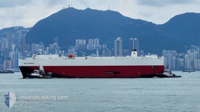
SIEM COPERNICUS
Vehicles Carrier
Current Trip
PH BTG
| Time Travelled | 1 day |
|---|---|
| Remaining Time | --- |
| Distance Travelled | 635.26 nm |
| Remaining Distance | --- |
| AVG Speed | 17.2 Knots |
| MAX Speed | 18.9 Knots |
| AVG Wind | 12 knots |
| MAX Wind | 19.6 knots |
| MIN Temp | 26.9°C / 80.42°F |
| MAX Temp | 29.3°C / 84.74°F |
| Draught | 8.4 m |
| Position Received | 4 d ago |
Current Position
| Longitude | 113.85295° |
|---|---|
| Latitude | 22.01102° |
| Status | Under way using engine |
| Speed | 12.3 Knots |
| Course | 165° |
| Area | South China Sea |
| Station | T-AIS |
| Position Received | 4 d ago |
Info
Information
The current position of SIEM COPERNICUS is in South China Sea with coordinates 22.01102° / 113.85295° as reported on 2024-06-16 23:40 by AIS to our vessel tracker app. The vessel's current speed is 12.3 Knots
The vessel SIEM COPERNICUS (IMO: 9448073, MMSI: 563149100) is a Vehicles Carrier that was built in 2010 ( 14 years old ). It's sailing under the flag of [SG] Singapore.
In this page you can find informations about the vessels current position, last detected port calls, and current voyage information. If the vessels is not in coverage by AIS you will find the latest position.
The current position of SIEM COPERNICUS is detected by our AIS receivers and we are not responsible for the reliability of the data. The last position was recorded while the vessel was in Coverage by the Ais receivers of our vessel tracking app.
The current draught of SIEM COPERNICUS as reported by AIS is 8.4 meters
Weather
| Temperature | 29.2°C / 84.56°F |
|---|---|
| Wind Speed | 21 knots |
| Direction | 255° WSW |
| Pressure | 1004.9 hPa |
| Humidity | 77.8 % |
| Cloud Coverage | 100 % |
Featured Company
Last Port Calls
| Port | Arrival | Departure | Time In Port |
|---|---|---|---|
| 2024-06-19 16:13 | 2024-06-19 23:37 | 7 h | |
| 2024-06-15 08:08 | 2024-06-15 14:26 | 6 h | |
| 2024-06-10 21:16 | 2024-06-11 13:49 | 16 h | |
| 2024-06-08 21:41 | 2024-06-09 06:10 | 8 h | |
| 2024-06-06 02:37 | 2024-06-07 06:31 | 1 d | |
| 2024-06-02 22:25 | 2024-06-03 02:37 | 4 h | |
| 2024-05-27 00:01 | 2024-05-28 15:33 | 1 d | |
| 2024-05-25 04:53 | 2024-05-26 02:36 | 21 h | |
| 2024-05-23 06:39 | 2024-05-23 12:24 | 5 h | |
| 2024-05-18 12:35 | 2024-05-18 20:36 | 8 h |
Last Trips
| Origin | Departure | Destination | Arrival | Distance | |
|---|---|---|---|---|---|
| 2024-06-15 22:26 | 2024-06-20 00:13 | 841.90 nm | |||
| 2024-06-11 22:49 | 2024-06-15 16:08 | 1499.83 nm | |||
| 2024-06-09 15:10 | 2024-06-11 06:16 | 205.06 nm | |||
| 2024-06-07 15:31 | 2024-06-09 06:41 | 375.17 nm | |||
| 2024-06-03 11:37 | 2024-06-06 11:37 | 279.95 nm | |||
| 2024-05-28 23:33 | 2024-06-03 07:25 | 1746.24 nm | |||
| 2024-05-26 10:36 | 2024-05-27 08:01 | 79.01 nm | |||
| 2024-05-23 20:24 | 2024-05-25 12:53 | 675.98 nm | |||
| 2024-05-19 04:36 | 2024-05-23 14:39 | 1534.46 nm | |||
| 2024-05-18 05:32 | 2024-05-18 20:35 | 201.06 nm |
Events
| Time | Event | Details | Position / Dest | Info |
|---|---|---|---|---|
| 2024-06-19 23:37 | PORT DEPARTURE |
|
13.75362 / 121.02793
PH BTG
|
Speed: 3.8 kn Course: 244° |
| 2024-06-19 23:29 | START Moving |
13.75847 / 121.03584
[PH] BATANGAS
|
Speed: 3.5 kn Course: 244° |
|
| 2024-06-19 16:37 | STOP Moving |
13.75880 / 121.03915
[PH] BATANGAS
|
Speed: 0.2 kn Course: 332° |
|
| 2024-06-19 16:13 | PORT ARRIVAL |
|
13.75705 / 121.03392
[PH] BATANGAS
|
Speed: 4.4 kn Course: 61° |
| 2024-06-19 15:53 | START Moving | 1.46 nm, West of BATANGAS |
13.75012 / 121.01123
PH BTG
|
Speed: 3.8 kn Course: 74° |
| 2024-06-19 11:09 | STOP Moving | 2.65 nm, South West of BATANGAS |
13.73312 / 120.99548
PH BTG
|
Speed: 0.1 kn Course: 208° |
| 2024-06-19 10:53 | START Moving | 2.51 nm, West of BATANGAS |
13.74002 / 120.99510
PH BTG
|
Speed: 3.4 kn Course: 160° |
| 2024-06-19 09:57 | STOP Moving | 2.39 nm, West of BATANGAS |
13.74152 / 120.99680
PH BTG
|
Speed: 0.2 kn Course: 59° |
| 2024-06-19 07:17 | START Moving | 2.09 nm, West of BATANGAS |
13.74133 / 121.00236
PH BTG
|
Speed: 3.4 kn Course: 209° |
| 2024-06-19 04:09 | STOP Moving | 1.99 nm, South West of BATANGAS |
13.73465 / 121.00751
PH BTG
|
Speed: 0.3 kn Course: 226° |