
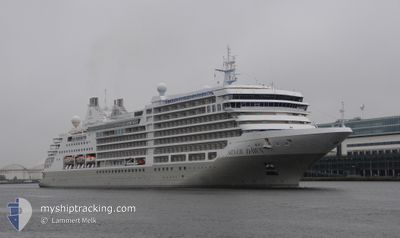
SILVER DAWN
Passenger
Current Trip
NO FLA-FLAM
| Time Travelled | 1 day |
|---|---|
| Remaining Time | --- |
| Distance Travelled | 330.80 nm |
| Remaining Distance | --- |
| AVG Speed | 15.5 Knots |
| MAX Speed | 18.6 Knots |
| AVG Wind | 10.4 knots |
| MAX Wind | 23.6 knots |
| MIN Temp | 2.4°C / 36.32°F |
| MAX Temp | 12.1°C / 53.78°F |
| Draught | 6.7 m |
| Position Received | 2 m ago |
Current Position
| Longitude | 4.74156° |
|---|---|
| Latitude | 62.08387° |
| Status | Under way using engine |
| Speed | 17.4 Knots |
| Course | 208.5° |
| Area | Norwegian Sea |
| Station | T-AIS |
| Position Received | 2 m ago |
Info
Information
The current position of SILVER DAWN is in Norwegian Sea with coordinates 62.08387° / 4.74156° as reported on 2024-06-10 20:49 by AIS to our vessel tracker app. The vessel's current speed is 17.4 Knots
The vessel SILVER DAWN (IMO: 9857937, MMSI: 311001044) is a Passenger It's sailing under the flag of [BS] Bahamas.
In this page you can find informations about the vessels current position, last detected port calls, and current voyage information. If the vessels is not in coverage by AIS you will find the latest position.
The current position of SILVER DAWN is detected by our AIS receivers and we are not responsible for the reliability of the data. The last position was recorded while the vessel was in Coverage by the Ais receivers of our vessel tracking app.
The current draught of SILVER DAWN as reported by AIS is 6.7 meters
Weather
| Temperature | 10.7°C / 51.26°F |
|---|---|
| Wind Speed | 23 knots |
| Direction | 11° N |
| Pressure | 1004.7 hPa |
| Humidity | 86.2 % |
| Cloud Coverage | 76 % |
Featured Company
Last Port Calls
| Port | Arrival | Departure | Time In Port |
|---|---|---|---|
| 2024-06-09 05:15 | 2024-06-09 13:57 | 8 h | |
| 2024-06-08 06:31 | 2024-06-08 16:01 | 9 h | |
| 2024-06-07 04:58 | 2024-06-07 13:03 | 8 h | |
| 2024-06-05 04:06 | 2024-06-05 17:06 | 12 h | |
| 2024-06-04 04:51 | 2024-06-04 16:38 | 11 h | |
| 2024-06-03 05:14 | 2024-06-03 18:42 | 13 h | |
| 2024-06-01 14:46 | 2024-06-02 16:26 | 1 d | |
| 2024-05-31 06:03 | 2024-05-31 15:58 | 9 h | |
| 2024-05-29 05:06 | 2024-05-29 15:16 | 10 h | |
| 2024-05-27 05:32 | 2024-05-27 14:53 | 9 h |
Last Trips
| Origin | Departure | Destination | Arrival | Distance | |
|---|---|---|---|---|---|
| 2024-06-08 18:01 | 2024-06-09 07:15 | 183.62 nm | |||
| 2024-06-07 15:03 | 2024-06-08 08:31 | 271.69 nm | |||
| 2024-06-05 19:06 | 2024-06-07 06:58 | 387.95 nm | |||
| 2024-06-04 18:38 | 2024-06-05 06:06 | 145.08 nm | |||
| 2024-06-03 20:42 | 2024-06-04 06:51 | 103.46 nm | |||
| 2024-06-02 18:26 | 2024-06-03 07:14 | 162.78 nm | |||
| 2024-05-31 17:58 | 2024-06-01 16:46 | 327.62 nm | |||
| 2024-05-29 17:16 | 2024-05-31 08:03 | 419.04 nm | |||
| 2024-05-27 16:53 | 2024-05-29 07:06 | 381.24 nm | |||
| 2024-05-24 19:15 | 2024-05-27 07:32 | 752.14 nm |
Events
| Time | Event | Details | Position / Dest | Info |
|---|---|---|---|---|
| 2024-06-10 14:39 | START Moving | 0.96 nm, North West of GEIRANGER |
62.11377 / 7.17696
NO FLA-FLAM
|
Speed: 7.2 kn Course: 303.3° |
| 2024-06-10 14:34 | Status Changed | Under way using engine At anchor |
62.11110 / 7.18561
NO FLA-FLAM
|
Speed: 0.5 kn Course: 331° |
| 2024-06-10 13:20 | Destination Changed | NO FLA-FLAM NO GNR-GEIRANGER |
62.10950 / 7.18786
NO FLA-FLAM
|
Speed: 0.1 kn Course: 296° |
| 2024-06-10 13:16 | ETA Changed | 2024/06/11 06:00 2024/06/10 05:15 |
62.10948 / 7.18783
NO GNR-GEIRANGER
|
Speed: 0.1 kn Course: 295° |
| 2024-06-10 12:53 | Status Changed | At anchor Default |
62.10956 / 7.18788
NO GNR-GEIRANGER
|
Speed: 0.1 kn Course: 296° |
| 2024-06-10 12:47 | Status Changed | Default At anchor |
62.10956 / 7.18789
NO GNR-GEIRANGER
|
Speed: 0.1 kn Course: 294° |
| 2024-06-10 05:23 | Status Changed | At anchor Under way using engine |
62.11069 / 7.18691
NO GNR-GEIRANGER
|
Speed: 0.8 kn Course: 348° |
| 2024-06-10 05:18 | STOP Moving | 0.66 nm, North West of GEIRANGER |
62.11124 / 7.18673
NO GNR-GEIRANGER
|
Speed: 0.3 kn Course: 23° |
| 2024-06-09 13:57 | PORT DEPARTURE |
|
63.44355 / 10.39385
NO GNR-GEIRANGER
|
Speed: 4.1 kn Course: 311° |
| 2024-06-09 13:56 | START Moving |
63.44295 / 10.39572
[NO] TRONDHEIM
|
Speed: 3.2 kn Course: 338° |