
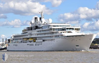
SILVER ENDEAVOUR
Passenger
Current Trip
| Time Travelled | 3 days |
|---|---|
| Remaining Time | --- |
| Distance Travelled | 580.04 nm |
| Remaining Distance | --- |
| AVG Speed | 11.6 Knots |
| MAX Speed | 17 Knots |
| AVG Wind | 15.7 knots |
| MAX Wind | 40.5 knots |
| MIN Temp | -0.4°C / 31.28°F |
| MAX Temp | 6.1°C / 42.98°F |
| Draught | 6.1 m |
| Position Received | 9 d ago |
Current Position
| Longitude | -6.41124° |
|---|---|
| Latitude | 56.45330° |
| Status | Under way using engine |
| Speed | 15 Knots |
| Course | 136.5° |
| Area | Inner Seas off the West Coast of Scotland |
| Station | T-AIS |
| Position Received | 9 d ago |
Info
Information
The current position of SILVER ENDEAVOUR is in Inner Seas off the West Coast of Scotland with coordinates 56.45330° / -6.41124° as reported on 2024-05-12 10:33 by AIS to our vessel tracker app. The vessel's current speed is 15 Knots and is heading at the port of LIPARI. The estimated time of arrival as calculated by vessel tracking app is 2024-05-12 06:00 LT
The vessel SILVER ENDEAVOUR (IMO: 9821873, MMSI: 311000932) is a Passenger It's sailing under the flag of [BS] Bahamas.
In this page you can find informations about the vessels current position, last detected port calls, and current voyage information. If the vessels is not in coverage by AIS you will find the latest position.
The current position of SILVER ENDEAVOUR is detected by our AIS receivers and we are not responsible for the reliability of the data. The last position was recorded while the vessel was in Coverage by the Ais receivers of our vessel tracking app.
The current draught of SILVER ENDEAVOUR as reported by AIS is 6.1 meters
Weather
| Temperature | 4.2°C / 39.56°F |
|---|---|
| Wind Speed | 1 knots |
| Direction | 354° N |
| Pressure | 1009.6 hPa |
| Humidity | 80.9 % |
| Cloud Coverage | 100 % |
Featured Company
Last Port Calls
| Port | Arrival | Departure | Time In Port |
|---|---|---|---|
| 2024-05-18 05:50 | 2024-05-18 19:19 | 13 h | |
| 2024-05-17 06:12 | 2024-05-17 13:48 | 7 h | |
| 2024-05-05 04:46 | 2024-05-05 17:46 | 13 h | |
| 2024-05-04 04:18 | 2024-05-04 19:02 | 14 h | |
| 2024-05-03 05:46 | 2024-05-03 17:46 | 12 h | |
| 2024-04-23 05:33 | 2024-04-23 17:27 | 11 h | |
| 2024-04-22 11:26 | 2024-04-22 20:02 | 8 h | |
| 2024-04-19 22:56 | 2024-04-20 22:07 | 23 h | |
| 2024-04-18 11:57 | 2024-04-18 16:53 | 4 h | |
| 2024-04-17 06:12 | 2024-04-17 16:55 | 10 h |
Most Visited Ports (Last year)
| Port | Arrivals | |
|---|---|---|
| 7 | ||
| 5 | ||
| 3 | ||
| 3 | ||
| 3 | ||
| 3 |
Last Trips
| Origin | Departure | Destination | Arrival | Distance | |
|---|---|---|---|---|---|
| 2024-05-17 13:48 | 2024-05-18 05:50 | 136.02 nm | |||
| 2024-05-05 18:46 | 2024-05-17 06:12 | 1788.46 nm | |||
| 2024-05-04 20:02 | 2024-05-05 05:46 | 124.75 nm | |||
| 2024-05-03 18:46 | 2024-05-04 05:18 | 124.85 nm | |||
| 2024-04-23 18:27 | 2024-05-03 06:46 | 1341.08 nm | |||
| 2024-04-22 21:02 | 2024-04-23 06:33 | 110.18 nm | |||
| 2024-04-20 23:07 | 2024-04-22 12:26 | 303.93 nm | |||
| 2024-04-18 17:53 | 2024-04-19 23:56 | 281.50 nm | |||
| 2024-04-17 17:55 | 2024-04-18 12:57 | 122.41 nm | |||
| 2024-04-07 13:25 | 2024-04-17 07:12 | 1703.28 nm |
Events
| Time | Event | Details | Position / Dest | Info |
|---|---|---|---|---|
| 2024-05-21 16:36 | START Moving | 0.86 nm, North West of HUSAVIK |
66.05128 / -17.38323
LUNGA
|
Speed: 5.5 kn Course: 304° |
| 2024-05-21 08:17 | STOP Moving | 0.61 nm, North West of HUSAVIK |
66.04940 / -17.37416
LUNGA
|
Speed: 0.2 kn Course: 15° |
| 2024-05-20 16:58 | STOP Moving | 0.66 nm, East of BOLUNGARVIK |
66.15985 / -23.21547
LUNGA
|
Speed: 0.2 kn Course: 10° |
| 2024-05-20 14:22 | STOP Moving | 0.63 nm, East of BOLUNGARVIK |
66.15977 / -23.21644
LUNGA
|
Speed: 0.3 kn Course: 323° |
| 2024-05-20 12:20 | START Moving | 2.71 nm, North East of SUDAVIK |
66.05500 / -22.88333
LUNGA
|
Speed: 9 kn Course: 318° |
| 2024-05-20 07:28 | STOP Moving | 3.05 nm, East of SUDAVIK |
66.04833 / -22.86333
LUNGA
|
Speed: Course: -1° |
| 2024-05-19 14:29 | START Moving | 11.34 nm, South East of BREIDAFJORDUR |
65.36558 / -22.96521
LUNGA
|
Speed: 4 kn Course: 210° |
| 2024-05-19 14:07 | STOP Moving | 11.24 nm, South East of BREIDAFJORDUR |
65.36833 / -22.96167
LUNGA
|
Speed: Course: -1° |
| 2024-05-19 12:00 | START Moving | 0.64 nm, North of STYKKISHOLMUR |
65.09061 / -22.73340
LUNGA
|
Speed: 9.2 kn Course: 266° |
| 2024-05-19 06:45 | STOP Moving | 0.45 nm, North East of STYKKISHOLMUR |
65.08334 / -22.71500
LUNGA
|
Speed: Course: -1° |