
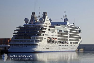
SILVER MOON
Passenger
Current Trip
| Time Travelled | 1 day |
|---|---|
| Remaining Time | 2 h, 3 mins |
| Distance Travelled | 511.08 nm |
| Remaining Distance | 34.94 nm |
| AVG Speed | 15.7 Knots |
| MAX Speed | 17.4 Knots |
| AVG Wind | 8.7 knots |
| MAX Wind | 12.9 knots |
| MIN Temp | 22.4°C / 72.32°F |
| MAX Temp | 25.3°C / 77.54°F |
| Draught | 6.7 m |
| Position Received | 1 m ago |
Current Position
| Longitude | 23.74991° |
|---|---|
| Latitude | 37.45895° |
| Status | Under way using engine |
| Speed | 14.7 Knots |
| Course | 359.2° |
| Area | Aegean Sea |
| Station | T-AIS |
| Position Received | 1 m ago |
Info
Information
The current position of SILVER MOON is in Aegean Sea with coordinates 37.45895° / 23.74991° as reported on 2024-06-09 00:40 by AIS to our vessel tracker app. The vessel's current speed is 14.7 Knots and is heading at the port of PIRAEUS. The estimated time of arrival as calculated by vessel tracking app is 2024-06-09 02:44 LT
The vessel SILVER MOON (IMO: 9838618, MMSI: 311000719) is a Passenger It's sailing under the flag of [BS] Bahamas.
In this page you can find informations about the vessels current position, last detected port calls, and current voyage information. If the vessels is not in coverage by AIS you will find the latest position.
The current position of SILVER MOON is detected by our AIS receivers and we are not responsible for the reliability of the data. The last position was recorded while the vessel was in Coverage by the Ais receivers of our vessel tracking app.
The current draught of SILVER MOON as reported by AIS is 6.7 meters
Weather
| Temperature | 23.8°C / 74.84°F |
|---|---|
| Wind Speed | 7 knots |
| Direction | 329° NNW |
| Pressure | 1010.6 hPa |
| Humidity | 72.4 % |
| Cloud Coverage | 7 % |
Featured Company
Last Port Calls
| Port | Arrival | Departure | Time In Port |
|---|---|---|---|
| 2024-06-07 06:25 | 2024-06-07 16:24 | 9 h | |
| 2024-06-01 08:22 | 2024-06-01 18:54 | 10 h | |
| 2024-05-20 06:25 | 2024-05-20 18:28 | 12 h | |
| 2024-05-04 22:56 | 2024-05-05 11:41 | 12 h | |
| 2024-04-27 21:31 | 2024-04-29 14:39 | 1 d | |
| 2024-04-24 22:12 | 2024-04-25 08:39 | 10 h | |
| 2024-04-22 21:52 | 2024-04-24 05:08 | 1 d | |
| 2024-04-20 22:28 | 2024-04-21 08:40 | 10 h | |
| 2024-04-16 22:11 | 2024-04-17 07:44 | 9 h | |
| 2024-04-15 21:39 | 2024-04-16 10:19 | 12 h |
Last Trips
| Origin | Departure | Destination | Arrival | Distance | |
|---|---|---|---|---|---|
| 2024-06-01 19:54 | 2024-06-07 08:25 | 1715.36 nm | |||
| 2024-05-20 20:28 | 2024-06-01 09:22 | 4451.37 nm | |||
| 2024-05-05 19:41 | 2024-05-20 08:25 | 5681.77 nm | |||
| 2024-04-29 22:39 | 2024-05-05 06:56 | 1569.13 nm | |||
| 2024-04-25 17:39 | 2024-04-28 05:31 | 997.76 nm | |||
| 2024-04-24 14:08 | 2024-04-25 07:12 | 273.92 nm | |||
| 2024-04-21 17:40 | 2024-04-23 06:52 | 570.53 nm | |||
| 2024-04-17 16:44 | 2024-04-21 07:28 | 1178.81 nm | |||
| 2024-04-16 19:19 | 2024-04-17 07:11 | 163.13 nm | |||
| 2024-04-15 18:33 | 2024-04-16 06:39 | 159.46 nm |
Events
| Time | Event | Details | Position / Dest | Info |
|---|---|---|---|---|
| 2024-06-08 21:35 | Status Changed | Under way using engine Default |
36.69042 / 23.73709
GR PIR
|
Speed: 14.9 kn Course: 1° |
| 2024-06-08 21:16 | Status Changed | Default Under way using engine |
36.61500 / 23.73667
GR PIR
|
Speed: 15 kn Course: 359.2° |
| 2024-06-08 20:42 | Status Changed | Under way using engine Default |
36.49054 / 23.66497
GR PIR
|
Speed: 15.2 kn Course: 38° |
| 2024-06-08 20:35 | Status Changed | Default Under way using engine |
36.46462 / 23.63979
GR PIR
|
Speed: 15.1 kn Course: 38° |
| 2024-06-08 18:13 | Change Sea Area | Greek part of the Aegean Sea Greek part of the Mediterranean Sea - Eastern Basin |
36.38642 / 23.01716
Aegean Sea
GR PIR
|
Speed: 15.5 kn Course: 111° |
| 2024-06-08 14:23 | Status Changed | Under way using engine Default |
36.25513 / 21.81419
GR PIR
|
Speed: 16 kn Course: 87° |
| 2024-06-08 14:15 | Status Changed | Default Under way using engine |
36.25349 / 21.77364
GR PIR
|
Speed: 16.1 kn Course: 87.4° |
| 2024-06-08 14:06 | Status Changed | Under way using engine Default |
36.25140 / 21.72122
GR PIR
|
Speed: 16.1 kn Course: 88° |
| 2024-06-08 13:47 | Status Changed | Default Under way using engine |
36.24717 / 21.61780
GR PIR
|
Speed: 15.9 kn Course: 86.1° |
| 2024-06-08 13:37 | Status Changed | Under way using engine Default |
36.24490 / 21.56486
GR PIR
|
Speed: 15.8 kn Course: 87° |