
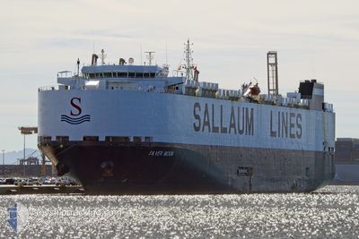
SILVER MOON
Vehicles Carrier
Current Trip
| Time Travelled | 16 days |
|---|---|
| Remaining Time | 2 days |
| Distance Travelled | 6228.05 nm |
| Remaining Distance | 1001.71 nm |
| AVG Speed | 15.8 Knots |
| MAX Speed | 18 Knots |
| AVG Wind | 12.1 knots |
| MAX Wind | 33 knots |
| MIN Temp | 14.7°C / 58.46°F |
| MAX Temp | 28.7°C / 83.66°F |
| Draught | 9 m |
| Position Received | 1 h, 50 m ago |
Current Position
| Longitude | -10.07052° |
|---|---|
| Latitude | 44.01632° |
| Status | Under way using engine |
| Speed | 14.6 Knots |
| Course | 32° |
| Area | North Atlantic Ocean |
| Station | T-AIS |
| Position Received | 1 h, 50 m ago |
Info
Information
The current position of SILVER MOON is in North Atlantic Ocean with coordinates 44.01632° / -10.07052° as reported on 2024-06-02 08:40 by AIS to our vessel tracker app. The vessel's current speed is 14.6 Knots and is heading at the port of BREMERHAVEN. The estimated time of arrival as calculated by vessel tracking app is 2024-06-05 07:10 LT
The vessel SILVER MOON (IMO: 9448138, MMSI: 353033000) is a Vehicles Carrier that was built in 2010 ( 14 years old ). It's sailing under the flag of [PA] Panama.
In this page you can find informations about the vessels current position, last detected port calls, and current voyage information. If the vessels is not in coverage by AIS you will find the latest position.
The current position of SILVER MOON is detected by our AIS receivers and we are not responsible for the reliability of the data. The last position was recorded while the vessel was in Coverage by the Ais receivers of our vessel tracking app.
The current draught of SILVER MOON as reported by AIS is 9 meters
Weather
| Temperature | 15.2°C / 59.36°F |
|---|---|
| Wind Speed | 24 knots |
| Direction | 59° ENE |
| Pressure | 1023.7 hPa |
| Humidity | 85.8 % |
| Cloud Coverage | --- |
Featured Company
Last Port Calls
| Port | Arrival | Departure | Time In Port |
|---|---|---|---|
| 2024-05-14 17:23 | 2024-05-16 23:16 | 2 d | |
| 2024-05-03 06:08 | 2024-05-05 05:52 | 1 d | |
| 2024-05-02 07:04 | 2024-05-02 18:20 | 11 h | |
| 2024-04-30 10:28 | 2024-05-01 09:52 | 23 h | |
| 2024-04-15 22:29 | 2024-04-17 06:43 | 1 d | |
| 2024-04-06 12:17 | 2024-04-08 03:23 | 1 d | |
| 2024-04-04 20:48 | 2024-04-05 20:16 | 23 h | |
| 2024-04-02 04:21 | 2024-04-03 00:36 | 20 h |
Most Visited Ports (Last year)
| Port | Arrivals | |
|---|---|---|
| 6 | ||
| 4 | ||
| 4 | ||
| 4 | ||
| 4 | ||
| 3 |
Last Trips
| Origin | Departure | Destination | Arrival | Distance | |
|---|---|---|---|---|---|
| 2024-05-05 06:52 | 2024-05-14 19:23 | 3410.56 nm | |||
| 2024-05-02 18:20 | 2024-05-03 07:08 | 155.31 nm | |||
| 2024-05-01 10:52 | 2024-05-02 07:04 | 90.60 nm | |||
| 2024-04-17 02:43 | 2024-04-30 11:28 | 5044.83 nm | |||
| 2024-04-07 23:23 | 2024-04-15 18:29 | 1566.38 nm | |||
| 2024-04-05 16:16 | 2024-04-06 08:17 | 164.99 nm | |||
| 2024-04-02 20:36 | 2024-04-04 16:48 | 529.52 nm | |||
| 2024-03-20 10:29 | 2024-04-02 00:21 | 4045.25 nm |
Events
| Time | Event | Details | Position / Dest | Info |
|---|---|---|---|---|
| 2024-06-02 08:41 | Status Changed | Default Under way using engine |
44.02105 / -10.06645
ZA DUB>>DE BRV
|
Speed: 14.6 kn Course: 32° |
| 2024-06-02 08:40 | OUT of Coverage |
44.01632 / -10.07052
North Atlantic Ocean
ZA DUB>>DE BRV
|
Speed: 14.6 kn Course: 32° |
|
| 2024-06-02 08:37 | Status Changed | Under way using engine Default |
44.00557 / -10.07998
ZA DUB>>DE BRV
|
Speed: 14.8 kn Course: 32° |
| 2024-06-02 08:10 | Status Changed | Default Under way using engine |
43.91273 / -10.16308
ZA DUB>>DE BRV
|
Speed: 14.7 kn Course: 31° |
| 2024-06-02 07:56 | Change Sea Area | Spanish part of the North Atlantic Ocean Portuguese part of the North Atlantic Ocean |
43.86480 / -10.20527
North Atlantic Ocean
ZA DUB>>DE BRV
|
Speed: 14.7 kn Course: 31° |
| 2024-06-02 07:56 | Status Changed | Under way using engine Default |
43.86480 / -10.20527
ZA DUB>>DE BRV
|
Speed: 14.6 kn Course: 31° |
| 2024-06-02 07:56 | IN Coverage |
43.86480 / -10.20527
North Atlantic Ocean
ZA DUB>>DE BRV
|
Speed: 14.7 kn Course: 31° |
|
| 2024-06-01 20:54 | Status Changed | Default Under way using engine |
41.54987 / -11.13823
ZA DUB>>DE BRV
|
Speed: 13.8 kn Course: 16° |
| 2024-06-01 20:53 | OUT of Coverage |
41.54572 / -11.13982
North Atlantic Ocean
ZA DUB>>DE BRV
|
Speed: 13.8 kn Course: 16° |
|
| 2024-06-01 12:24 | Status Changed | Under way using engine Default |
39.52063 / -11.90343
ZA DUB>>DE BRV
|
Speed: 14.9 kn Course: 16° |