
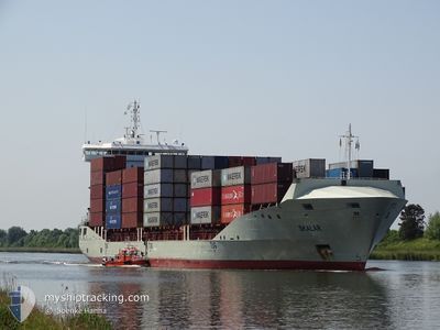
SKALAR
Container Ship
Current Trip
| Time Travelled | 16 h, 38 mins |
|---|---|
| Remaining Time | 1 day |
| Distance Travelled | 107.25 nm |
| Remaining Distance | 616.63 nm |
| AVG Speed | 8.1 Knots |
| MAX Speed | 16.9 Knots |
| AVG Wind | 9.2 knots |
| MAX Wind | 15 knots |
| MIN Temp | 10.1°C / 50.18°F |
| MAX Temp | 23.7°C / 74.66°F |
| Draught | 6.9 m |
| Position Received | Now |
Current Position
| Longitude | 10.60750° |
|---|---|
| Latitude | 54.56070° |
| Status | Under way using engine |
| Speed | 13.6 Knots |
| Course | 83.4° |
| Area | Baltic Sea |
| Station | T-AIS |
| Position Received | Now |
Info
Information
The current position of SKALAR is in Baltic Sea with coordinates 54.56070° / 10.60750° as reported on 2024-05-18 05:18 by AIS to our vessel tracker app. The vessel's current speed is 13.6 Knots and is heading at the port of RAUMA. The estimated time of arrival as calculated by vessel tracking app is 2024-05-19 18:32 LT
The vessel SKALAR (IMO: 9458975, MMSI: 255806476) is a Container Ship that was built in 2012 ( 12 years old ). It's sailing under the flag of [PT] Portugal.
In this page you can find informations about the vessels current position, last detected port calls, and current voyage information. If the vessels is not in coverage by AIS you will find the latest position.
The current position of SKALAR is detected by our AIS receivers and we are not responsible for the reliability of the data. The last position was recorded while the vessel was in Coverage by the Ais receivers of our vessel tracking app.
The current draught of SKALAR as reported by AIS is 6.9 meters
Weather
| Temperature | 12.7°C / 54.86°F |
|---|---|
| Wind Speed | 13 knots |
| Direction | 84° E |
| Pressure | 1012.4 hPa |
| Humidity | 87.6 % |
| Cloud Coverage | 4 % |
Featured Company
Last Port Calls
| Port | Arrival | Departure | Time In Port |
|---|---|---|---|
| 2024-05-16 06:33 | 2024-05-17 12:41 | 1 d | |
| 2024-05-15 03:00 | 2024-05-15 23:19 | 20 h | |
| 2024-05-12 03:53 | 2024-05-12 19:15 | 15 h | |
| 2024-05-07 19:31 | 2024-05-08 13:12 | 17 h | |
| 2024-05-06 21:01 | 2024-05-07 11:09 | 14 h | |
| 2024-05-05 11:09 | 2024-05-06 00:15 | 13 h | |
| 2024-05-01 03:05 | 2024-05-01 23:55 | 20 h | |
| 2024-04-26 23:50 | 2024-04-28 16:10 | 1 d | |
| 2024-04-26 04:48 | 2024-04-26 15:18 | 10 h | |
| 2024-04-21 14:16 | 2024-04-21 20:54 | 6 h |
Most Visited Ports (Last year)
| Port | Arrivals | |
|---|---|---|
| 38 | ||
| 18 | ||
| 16 | ||
| 16 | ||
| 11 | ||
| 11 |
Last Trips
| Origin | Departure | Destination | Arrival | Distance | |
|---|---|---|---|---|---|
| 2024-05-16 01:19 | 2024-05-16 08:33 | 113.42 nm | |||
| 2024-05-12 22:15 | 2024-05-15 05:00 | 755.14 nm | |||
| 2024-05-08 15:12 | 2024-05-12 06:53 | 869.66 nm | |||
| 2024-05-07 13:09 | 2024-05-07 21:31 | 114.41 nm | |||
| 2024-05-06 02:15 | 2024-05-06 23:01 | 120.24 nm | |||
| 2024-05-02 02:55 | 2024-05-05 13:09 | 787.03 nm | |||
| 2024-04-28 18:10 | 2024-05-01 06:05 | 751.00 nm | |||
| 2024-04-26 17:18 | 2024-04-27 01:50 | 114.38 nm | |||
| 2024-04-21 22:54 | 2024-04-26 06:48 | 1039.13 nm | |||
| 2024-04-21 15:13 | 2024-04-21 16:16 | 12.02 nm |
Events
| Time | Event | Details | Position / Dest | Info |
|---|---|---|---|---|
| 2024-05-18 05:16 | Change Sea Area | Danish part of the Baltic Sea German part of the Baltic Sea |
54.55918 / 10.59412
Baltic Sea
FIRAU
|
Speed: 13.8 kn Course: 75.4° |
| 2024-05-18 04:20 | Change Sea Area | German part of the Baltic Sea German part of the North Sea |
54.46107 / 10.26023
Baltic Sea
FIRAU
|
Speed: 17.2 kn Course: 35.3° |
| 2024-05-18 04:18 | ETA Changed | 2024/05/20 06:00 2024/05/16 09:00 |
54.45036 / 10.24704
FIRAU
|
Speed: 18 kn Course: 35.7° |
| 2024-05-18 03:41 | START Moving | 1.31 nm, South West of STICKENHΟRN SPORT |
54.36563 / 10.14490
DEHAM
|
Speed: 3.1 kn Course: 106° |
| 2024-05-18 03:12 | STOP Moving | 1.38 nm, South West of STICKENHΟRN SPORT |
54.36621 / 10.14093
DEHAM
|
Speed: 0.2 kn Course: 106° |
| 2024-05-18 01:55 | Draught Changed | 6.9 6 |
54.34257 / 9.96938
DEHAM
|
Speed: 6.6 kn Course: 77.3° |
| 2024-05-18 01:55 | ETA Changed | 2024/05/16 09:00 |
54.34257 / 9.96938
DEHAM
|
Speed: 6.6 kn Course: 77.3° |
| 2024-05-18 01:49 | Draught Changed | 6 6.9 |
54.34136 / 9.95720
DEHAM
|
Speed: 2.5 kn Course: 81° |
| 2024-05-17 20:11 | START Moving | 1.34 nm, North of HOCHDONN |
54.04080 / 9.30428
DEHAM
|
Speed: 3.4 kn Course: 7° |
| 2024-05-17 19:28 | STOP Moving | 1.21 nm, North of HOCHDONN |
54.03860 / 9.30410
DEHAM
|
Speed: 0.2 kn Course: 10° |