
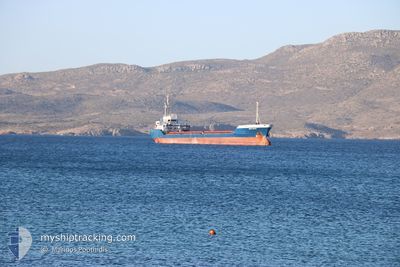
SKY FEYZ
General Cargo
Current Trip
| Trip Time | --- |
|---|---|
| Trip Distance | --- |
| AVG Speed | --- |
| MAX Speed | --- |
| Draught | --- |
| AVG Wind | --- |
| MAX Wind | --- |
| MIN Temp | --- |
| MAX Temp | --- |
| Position Received | 5 d ago |
Current Position
| Longitude | 35.49081° |
|---|---|
| Latitude | 33.81827° |
| Status | Under way using engine |
| Speed | |
| Course | 280° |
| Area | Mediterranean Sea - Eastern Basin |
| Station | T-AIS |
| Position Received | 5 d ago |
Info
Information
The current position of SKY FEYZ is in Mediterranean Sea - Eastern Basin with coordinates 33.81827° / 35.49081° as reported on 2024-06-04 21:32 by AIS to our vessel tracker app. The vessel's current speed is 0 Knots and is currently inside the port of ALEXANDRIA.
The vessel SKY FEYZ (IMO: 9116034, MMSI: 355997000) is a General Cargo that was built in 1995 ( 29 years old ). It's sailing under the flag of [PA] Panama.
In this page you can find informations about the vessels current position, last detected port calls, and current voyage information. If the vessels is not in coverage by AIS you will find the latest position.
The current position of SKY FEYZ is detected by our AIS receivers and we are not responsible for the reliability of the data. The last position was recorded while the vessel was in Coverage by the Ais receivers of our vessel tracking app.
The current draught of SKY FEYZ as reported by AIS is 3.2 meters
Weather
| Temperature | 24°C / 75.2°F |
|---|---|
| Wind Speed | 9 knots |
| Direction | 303° WNW |
| Pressure | 1009.8 hPa |
| Humidity | 77.4 % |
| Cloud Coverage | --- |
Featured Company
Last Port Calls
| Port | Arrival | Departure | Time In Port |
|---|---|---|---|
| 2024-06-07 04:33 | |||
| 2024-06-02 19:55 | |||
| 2024-05-28 14:08 | 2024-05-30 08:38 | 1 d | |
| 2024-05-13 09:44 | 2024-05-14 20:04 | 1 d | |
| 2024-05-03 16:11 | 2024-05-07 18:27 | 4 d | |
| 2024-05-02 05:04 | 2024-05-02 15:53 | 10 h | |
| 2024-04-24 15:04 | 2024-04-24 15:06 | 1 m | |
| 2024-04-21 12:32 | 2024-04-21 13:09 | 37 m | |
| 2024-04-15 13:26 | 2024-04-21 04:46 | 5 d | |
| 2024-04-12 12:05 | 2024-04-12 17:19 | 5 h |
Last Trips
| Origin | Departure | Destination | Arrival | Distance | |
|---|---|---|---|---|---|
| 2024-05-30 10:38 | 2024-06-02 22:55 | 385.21 nm | |||
| 2024-05-14 23:04 | 2024-05-28 16:08 | 1391.68 nm | |||
| 2024-05-07 21:27 | 2024-05-13 12:44 | 523.19 nm | |||
| 2024-05-02 18:53 | 2024-05-03 19:11 | 243.49 nm | |||
| 2024-04-24 17:06 | 2024-05-02 08:04 | 1703.28 nm | |||
| 2024-04-21 15:09 | 2024-04-24 17:04 | 6.97 nm | |||
| 2024-04-21 06:46 | 2024-04-21 14:32 | 73.84 nm | |||
| 2024-04-12 18:19 | 2024-04-15 15:26 | 468.60 nm | |||
| 2024-03-25 16:34 | 2024-04-12 13:05 | 1199.84 nm |
Events
| Time | Event | Details | Position / Dest | Info |
|---|---|---|---|---|
| 2024-06-07 05:15 | STOP Moving |
31.18566 / 29.87962
[EG] ALEXANDRIA
|
Speed: 0.2 kn Course: 358° |
|
| 2024-06-07 04:33 | PORT ARRIVAL |
|
31.16140 / 29.84321
[EG] ALEXANDRIA
|
Speed: 7.9 kn Course: 116° |
| 2024-06-07 03:36 | START Moving | 3.43 nm, North West of EL DEKHEILA |
31.19095 / 29.76427
EGALY
|
Speed: 7.2 kn Course: 116° |
| 2024-06-06 07:32 | STOP Moving | 3.98 nm, North West of EL DEKHEILA |
31.19500 / 29.75333
EGALY
|
Speed: Course: -1° |
| 2024-06-04 21:32 | OUT of Coverage |
33.81827 / 35.49081
Mediterranean Sea - Eastern Basin
EGALY
|
Speed: Course: 280° |
|
| 2024-06-04 18:54 | Status Changed | Under way using engine At anchor |
33.81828 / 35.49116
EGALY
|
Speed: Course: 287° |
| 2024-06-04 18:38 | Destination Changed | EGALY WAITING ORDER |
33.81827 / 35.49079
EGALY
|
Speed: Course: 287° |
| 2024-06-04 18:38 | ETA Changed | 2024/06/06 07:00 2024/06/03 15:40 |
33.81827 / 35.49079
EGALY
|
Speed: Course: 287° |
| 2024-06-04 01:42 | IN Coverage |
33.81826 / 35.49081
Mediterranean Sea - Eastern Basin
|
Speed: Course: 196° |
|
| 2024-06-04 00:13 | OUT of Coverage |
33.81826 / 35.49079
Mediterranean Sea - Eastern Basin
|
Speed: Course: 243° |