
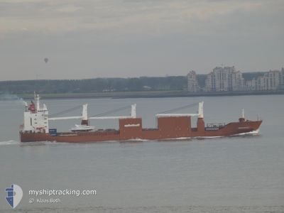
SNOEKGRACHT
General Cargo
Current Trip
| Time Travelled | 5 days |
|---|---|
| Remaining Time | --- |
| Distance Travelled | 1669.83 nm |
| Remaining Distance | --- |
| AVG Speed | 13.6 Knots |
| MAX Speed | 17.6 Knots |
| AVG Wind | 8.5 knots |
| MAX Wind | 21 knots |
| MIN Temp | 17.4°C / 63.32°F |
| MAX Temp | 21.9°C / 71.42°F |
| Draught | 7.1 m |
| Position Received | 1 m ago |
Current Position
| Longitude | -3.01442° |
|---|---|
| Latitude | 36.31567° |
| Status | Under way using engine |
| Speed | 16.5 Knots |
| Course | 260.6° |
| Area | Alboran Sea |
| Station | T-AIS |
| Position Received | 1 m ago |
Info
Information
The current position of SNOEKGRACHT is in Alboran Sea with coordinates 36.31567° / -3.01442° as reported on 2024-05-17 10:28 by AIS to our vessel tracker app. The vessel's current speed is 16.5 Knots and is heading at the port of RAUMA. The estimated time of arrival as calculated by vessel tracking app is 2024-05-26 15:00 LT
The vessel SNOEKGRACHT (IMO: 9202546, MMSI: 245816000) is a General Cargo that was built in 2000 ( 24 years old ). It's sailing under the flag of [NL] Netherlands.
In this page you can find informations about the vessels current position, last detected port calls, and current voyage information. If the vessels is not in coverage by AIS you will find the latest position.
The current position of SNOEKGRACHT is detected by our AIS receivers and we are not responsible for the reliability of the data. The last position was recorded while the vessel was in Coverage by the Ais receivers of our vessel tracking app.
The current draught of SNOEKGRACHT as reported by AIS is 7.1 meters
Weather
| Temperature | 17.5°C / 63.5°F |
|---|---|
| Wind Speed | 20 knots |
| Direction | 257° WSW |
| Pressure | 1010.7 hPa |
| Humidity | 85.8 % |
| Cloud Coverage | --- |
Featured Company
Last Port Calls
| Port | Arrival | Departure | Time In Port |
|---|---|---|---|
| 2024-05-11 03:21 | 2024-05-11 14:57 | 11 h | |
| 2024-05-05 13:40 | 2024-05-08 07:01 | 2 d | |
| 2024-04-30 03:05 | 2024-04-30 21:18 | 18 h | |
| 2024-04-16 04:21 | 2024-04-17 02:48 | 22 h | |
| 2024-04-13 01:56 | 2024-04-14 13:22 | 1 d | |
| 2024-04-07 22:08 | 2024-04-09 18:35 | 1 d | |
| 2024-04-04 22:39 | 2024-04-05 22:51 | 1 d | |
| 2024-03-30 12:59 | 2024-04-02 05:09 | 2 d | |
| 2024-03-27 17:20 | 2024-03-28 18:49 | 1 d | |
| 2024-03-07 22:19 | 2024-03-09 10:34 | 1 d |
Most Visited Ports (Last year)
| Port | Arrivals | |
|---|---|---|
| 5 | ||
| 3 | ||
| 3 | ||
| 3 | ||
| 3 | ||
| 3 |
Last Trips
| Origin | Departure | Destination | Arrival | Distance | |
|---|---|---|---|---|---|
| 2024-05-08 08:01 | 2024-05-11 05:21 | 988.12 nm | |||
| 2024-04-30 22:18 | 2024-05-05 14:40 | 1579.58 nm | |||
| 2024-04-16 21:48 | 2024-04-30 04:05 | 4706.56 nm | |||
| 2024-04-14 08:22 | 2024-04-15 23:21 | 577.64 nm | |||
| 2024-04-09 13:35 | 2024-04-12 20:56 | 810.60 nm | |||
| 2024-04-05 16:51 | 2024-04-07 17:08 | 808.35 nm | |||
| 2024-04-02 00:09 | 2024-04-04 16:39 | 512.85 nm | |||
| 2024-03-28 12:49 | 2024-03-30 07:59 | 653.10 nm | |||
| 2024-03-09 11:34 | 2024-03-27 11:20 | 6307.29 nm | |||
| 2024-03-06 20:40 | 2024-03-07 23:19 | 388.26 nm |
Events
| Time | Event | Details | Position / Dest | Info |
|---|---|---|---|---|
| 2024-05-17 09:12 | Draught Changed | 7.1 7 |
36.36364 / -2.58529
FIRAU
|
Speed: 16.5 kn Course: 262.1° |
| 2024-05-17 09:12 | ETA Changed | 2024/05/26 15:00 |
36.36364 / -2.58529
FIRAU
|
Speed: 16.5 kn Course: 262.1° |
| 2024-05-17 07:36 | Change Sea Area | Spanish part of the Alboran Sea Spanish part of the Mediterranean Sea - Western Basin |
36.46398 / -2.05107
Alboran Sea
|
Speed: 17.1 kn Course: 248.2° |
| 2024-05-17 07:36 | Status Changed | Under way using engine Default |
36.46398 / -2.05107
FIRAU
|
Speed: 17.1 kn Course: 250° |
| 2024-05-17 07:28 | IN Coverage |
36.46398 / -2.05107
Alboran Sea
|
Speed: 17.1 kn Course: 248.2° |
|
| 2024-05-17 05:54 | Status Changed | Default Under way using engine |
36.61380 / -1.48314
FIRAU
|
Speed: 16.9 kn Course: 253.2° |
| 2024-05-17 05:39 | OUT of Coverage |
36.63468 / -1.39621
Mediterranean Sea - Western Basin
|
Speed: 16.9 kn Course: 253.2° |
|
| 2024-05-17 04:15 | Status Changed | Under way using engine Default |
36.74781 / -.95150
FIRAU
|
Speed: 16.3 kn Course: 253° |
| 2024-05-17 03:51 | Status Changed | Default Under way using engine |
36.78099 / -.81979
FIRAU
|
Speed: 16.4 kn Course: 253.3° |
| 2024-05-17 03:44 | Status Changed | Under way using engine Default |
36.79041 / -.78157
FIRAU
|
Speed: 16.4 kn Course: 253° |